In partnership with: 
|
January 28, 2011 at 8:01 am |
|
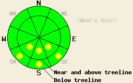
The avalanche danger should remain LOW for all elevations and aspects for most of the day. Pockets of MODERATE danger may form this afternoon on SE-S-SW aspects 35 degrees and steeper in response to daytime warming. |
|
|
|
After a warm day yesterday with daytime highs in the 50's above 8000 ft, temperatures across the region remained above freezing for the second night in a row last night. The persistent high pressure ridge should allow those warm temperatures and sunny skies to continue today. The forecast calls for the winds to remain light and out of the west. By tomorrow cloud cover should start to increase over the forecast area, and the winds should shift to the southwest and increase due to a low pressure system approaching the region from the Gulf of Alaska. This system should arrive Saturday night and could even bring some snow with it (see the NWS site for more details).
Even though temperatures stayed above freezing on Wednesday night, observations during the day yesterday on Donner Pass, Castle Peak, and on Ralston Peak all indicated a good refreeze due to the snowpack radiating heat out into the night sky. In each of these areas, 2-4 inches of soft corn snow formed on the SE-S-SW aspects due to daytime warming. This softer wet snow started to refreeze as soon as the sun left the slopes. Below the soft, wet snow, a firm, frozen supportable crust ranging from 4-8 inches in thickness existed in these areas (pit from Donner Pass). On the more northerly aspects due to the extended clear weather and colder temperatures on these aspects, the frozen rain crust on the surface has become more variable in thickness. In some areas it remains thick and supportable (video from Castle Peak), and in some areas it has become a thin and breakable (more info from Ralston Peak). Below this variable rain crust on the northerly aspects weak sugary snow has formed.
Primary Avalanche Concern: Wet Snow Instabilities
Even though overnight temperatures remained a few degrees above freezing last night, the clear night skies should have allowed the snowpack to release enough heat into space for a decent refreeze to occur. As the sun hits the slopes and the temperatures climb into the high 40's again today, the frozen snow will start to melt and weaken. In most areas not enough enough melting should occur for dangerous wet snow instabilities to form. However, some larger wet loose snow sluffs that could push someone into an area with serious consequences may become possible in isolated areas on the most sun-exposed and warmest SE-S-SW aspects. Use clues like smaller wet surface instabilities (roller balls, small sluffs) and shin-deep wet snow to determine where the weakest wet snow exists.
The avalanche danger should remain LOW for all elevations and aspects for most of the day. Pockets of MODERATE danger may form this afternoon on SE-S-SW aspects 35 degrees and steeper in response to daytime warming.
| 0600 temperature: | 35-37 deg. F. |
| Max. temperature in the last 24 hours: | 45-54 deg. F. |
| Average wind direction during the last 24 hours: | West |
| Average wind speed during the last 24 hours: | 10 mph |
| Maximum wind gust in the last 24 hours: | 20 mph |
| New snowfall in the last 24 hours: | O inches |
| Total snow depth: | 59-87 inches |
For 7000-8000 ft: |
|||
| Friday: | Friday Night: | Saturday: | |
| Weather: | Sunny | Clear | Partly cloudy in the morning becoming mostly cloudy in the afternoon |
| Temperatures: | 43-50 deg. F. | 24-30 deg. F. | 36-43 deg. F. |
| Wind direction: | West to Northwest | Southwest | Southwest |
| Wind speed: | Light | around 10 mph | 10-20 mph with gusts to 30 mph |
| Expected snowfall: | O in. | O in. | O in. |
For 8000-9000 ft: |
|||
| Friday: | Friday Night: | Saturday: | |
| Weather: | Sunny | Clear | Partly cloudy in the morning becoming mostly cloudy in the afternoon |
| Temperatures: | 40-47 deg. F. | 21-28 deg. F. | 32-39 deg. F. |
| Wind direction: | West to Northwest | West | Southwest |
| Wind speed: | around 10 mph | around 10 mph | 15-20 mph with gusts to 35 mph increasing to 20-30 mph with gusts to 55 mph |
| Expected snowfall: | O in. | O in. | O in. |


This website is owned and maintained by the non-profit arm of the Sierra Avalanche Center. Some of the content is updated by the USDA avalanche forecasters including the forecasts and some observational data. The USDA is not responsible for any advertising, fund-raising events/information, or sponsorship information, or other content not related to the forecasts and the data pertaining to the forecasts.

