In partnership with: 
|
January 29, 2011 at 8:01 am |
|
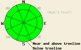
The avalanche danger should remain LOW for all elevations and aspects for most of the day. Use normal caution when traveling in the backcountry. |
|
|
|
Temperatures dropped below freezing at the higher elevations and very close to freezing at most of the lower elevations last night. The winds shifted more to the southwest and have started to pull warm air into the region. The forecast calls for one more warm day with daytime highs in the mid to upper 40's above 7000 ft. today. The winds should continue from the southwest and clouds should increase as a low pressure approaches from the Gulf of Alaska. By tonight temperatures should drop well below freezing and some snow showers should begin. The snow should continue through Sunday with the forecast calling for 4-8 inches of new snow above 7000 ft (weather graphic from the NWS). This system will also bring a mass of cold air to the forecast area. Daytime highs above 7000 ft tomorrow should only reach into the mid 20's.
Observations from Waterhouse Peak yesterday showed melt-freeze and variable crust conditions similar to those seen across the forecast area during this week. A strong refreeze occurred on Thursday night in this area. During the day yesterday enough warming occurred for a few inches of soft corn snow to form on top of a thick, strong, refrozen melt-freeze crust on the sunny SE-S-SW aspects up to 9200 ft by noon (video). On less sunny northerly aspects, a thinner, sometimes-breakable, sometimes-supportable crust existed with a layer of video). E aspects held some of both of these conditions depending on how much sun they received. Ski cuts and hand pits on all these aspects did not show any signs of instability.
Avalanche Concerns:
The snow that melted and softened yesterday should have refrozen well last night due to the combination of overnight lows close to and below freezing and clear skies that allowed the snowpack to radiate heat into space until the clouds moved in early this morning. Slightly cooler temperatures and more widespread cloud cover today should limit the melting that occurs. Less melting means less chance for wet snow instabilities to form, but it also means more hard and frozen snow surfaces. If more melting occurs than expected, some wet snow instabilities may become possible in isolated areas on the warmest aspects. Over the next 24 hours as winter returns to the forecast area and new snow starts to fall on the frozen crusts and the thin breakable crusts with weak snow below them, the avalanche danger will increase.
The avalanche danger should remain LOW for all elevations and aspects for most of the day. Use normal caution when traveling in the backcountry.
| 0600 temperature: | 29-32 deg. F. |
| Max. temperature in the last 24 hours: | 42-50 deg. F. |
| Average wind direction during the last 24 hours: | West southwest |
| Average wind speed during the last 24 hours: | 20 mph |
| Maximum wind gust in the last 24 hours: | 42 mph |
| New snowfall in the last 24 hours: | O inches |
| Total snow depth: | 58-87 inches |
For 7000-8000 ft: |
|||
| Saturday: | Saturday Night: | Sunday: | |
| Weather: | Partly cloudy this morning becoming mostly cloudy this afternoon | Cloudy with snow showers. Snow showers becoming more widespread after midnight. | Snow showers |
| Temperatures: | 44-50 deg. F. | 14-21 deg. F. | 18-25 deg. F. |
| Wind direction: | Southwest | Southwest | West shifting to the north in the afternoon |
| Wind speed: | 10-20 mph with gusts to 35 mph | 10-20 mph with gusts to 45 mph | 10-15 mph with gusts to 35 mph |
| Expected snowfall: | O in. | up to 2 in. | 3-6 in. |
For 8000-9000 ft: |
|||
| Saturday: | Saturday Night: | Sunday: | |
| Weather: | Partly cloudy this morning becoming mostly cloudy this afternoon | Cloudy with snow showers. Snow showers becoming more widespread after midnight. | Snow showers |
| Temperatures: | 37-44 deg. F. | 15-21 deg. F. | 13-20 deg. F. |
| Wind direction: | Southwest | Southwest | West shifting to the north in the afternoon |
| Wind speed: | 20-30 mph with gusts to 50 mph | 20-35 mph with gusts to 50 mph | 20-30 mph with gusts to 45 mph decreasing to 10-20 mph with gusts to 35 mph in the afternoon |
| Expected snowfall: | O in. | up to 2 in. | 3-6 in. |


This website is owned and maintained by the non-profit arm of the Sierra Avalanche Center. Some of the content is updated by the USDA avalanche forecasters including the forecasts and some observational data. The USDA is not responsible for any advertising, fund-raising events/information, or sponsorship information, or other content not related to the forecasts and the data pertaining to the forecasts.

