In partnership with: 
|
January 30, 2011 at 8:00 am |
|
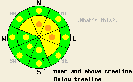
Near and above treeline on slopes steeper than 35 degrees, MODERATE avalanche danger exists on NW-N-NE-E-SE aspects with pockets of MODERATE danger on the S-SW-W aspects. Some pockets of CONSIDERABLE danger may form on the most wind-loaded N-NE-E aspects along the Sierra Crest. Below treeline on slopes steeper than 35 degrees, pockets of MODERATE danger exist on all aspects. |
|
|
|
Cold, light snow started to fall early this morning along the Sierra Crest. Since then snowfall rates have averaged 1-2 inches per hour leaving 4-6 inches of new snow above 7000 ft along the Sierra Crest. The storm has not impacted the mountains east of Lake Tahoe nearly as much. Remote sensors in those areas reported less than an inch of new snow this morning. As the low pressure continues to move across the forecast area today, it should bring another 4-8 inches of snow above 7000 ft in the Sierra west of Lake Tahoe. Areas east of Lake Tahoe above 7000 ft should see 4-7 inches of new snow today. Most of this snow should fall before noon. The snow showers should start to taper off this afternoon and should end tonight as the low pressure moves east of the region. The southwest winds should continue this morning; however, as the storm moves east this afternoon, the winds should decrease and shift to the north. The forecast calls for the cold temperatures and north winds to continue through Monday.
More cloud cover and cooler temperatures kept the snow surface mostly frozen yesterday. On Shallenberger Ridge even the low elevation south facing slopes remained hard and frozen all day. On the N-NE-E aspects, conditions similar to those noted on other northerly aspect across the forecast area this week existed with a variable rain crust on top of a layer of weak sugary snow. Both the frozen melt-freeze crusts and the variable crusts with facets below will provide excellent and efficient bed surfaces for Wind Slabs
The southwest and west winds will continue to deposit more new snow onto the wind-loaded N-NE-E aspects and into cross-loaded NW and SE aspects creating new wind slabs in these areas. Since wind-loading can multiply the depth of snow by many times, the 7-14 inches of total accumulation expected could easily turn into wind slabs a few feet in depth. With the bed surfaces previously mentioned below these wind slabs, they will only need a trigger to make them fail, and the resulting avalanches may run farther down-slope than usual. Human-triggering of these wind slabs will be possible today. In isolated near and above treeline areas along the Sierra Crest that receive the most wind loading, enough snow may accumulate for some natural avalanches to occur. Depending on the strength and timing of the north winds today, some small shallow wind slabs may also form on the W-SW-S-SE aspects later this afternoon.
Secondary Avalanche Concern: Storm Snow
Due to the efficient bed surfaces below the new snow and the weak bonding expected to occur between these surfaces and the new snow, human-triggerable avalanche activity will be possible on non-wind-loaded slopes as well today. Most of this activity should present as long-running, loose snow sluffs; however, some soft slab avalanches may also occur. In areas that receive the most accumulation today these slides could become large enough to push someone into an area that could have serious consequences or even bury someone in a gully or other terrain trap. This kind of avalanche activity should only involve the new snow. Any slopes steeper than 35 degrees with significant new snow on them will be suspect today.
Near and above treeline on slopes steeper than 35 degrees, MODERATE avalanche danger exists on NW-N-NE-E-SE aspects with pockets of MODERATE danger on the S-SW-W aspects. Some pockets of CONSIDERABLE danger may form on the most wind-loaded N-NE-E aspects along the Sierra Crest. Below treeline on slopes steeper than 35 degrees, pockets of MODERATE danger exist on all aspects.
| 0600 temperature: | 18-22 deg. F. |
| Max. temperature in the last 24 hours: | 35-42 deg. F. |
| Average wind direction during the last 24 hours: | Southwest |
| Average wind speed during the last 24 hours: | 35-45 mph |
| Maximum wind gust in the last 24 hours: | 85 mph |
| New snowfall in the last 24 hours: | 4-8 inches |
| Total snow depth: | 58-88 inches |
For 7000-8000 ft: |
|||
| Sunday: | Sunday Night: | Monday: | |
| Weather: | Snow in the morning. Snow should taper off to isolated showers by the afternoon | Mostly cloudy with a few isolated snow showers before midnight | Partly cloudy |
| Temperatures: | 20-27 deg. F. | 12-19 deg. F. | 23-30 deg. F. |
| Wind direction: | West southwest shifting to north in the afternoon | North | North |
| Wind speed: | 10-15 mph with gusts to 25 mph deceasing to around 10 mph in the afternoon | 10-15 mph with gusts to 25 mph | 10-15 mph with gusts to 25 mph |
| Expected snowfall: | 4-8 in. | trace in. | O in. |
For 8000-9000 ft: |
|||
| Sunday: | Sunday Night: | Monday: | |
| Weather: | Snow in the morning. Snow should taper off to isolated showers by the afternoon | Mostly cloudy with a few isolated snow showers before midnight | Partly cloudy |
| Temperatures: | 16-23 deg. F. | 11-18 deg. F. | 19-26 deg. F. |
| Wind direction: | West southwest shifting to north in the afternoon | North | North |
| Wind speed: | 20-30 mph with gusts to 50 mph decreasing to 15-25 mph with gusts to 35 mph | 15-25 mph with gusts to 40 mph | 15-25 mph with gusts to 40 mph |
| Expected snowfall: | 4-8 in. | trace in. | O in. |


This website is owned and maintained by the non-profit arm of the Sierra Avalanche Center. Some of the content is updated by the USDA avalanche forecasters including the forecasts and some observational data. The USDA is not responsible for any advertising, fund-raising events/information, or sponsorship information, or other content not related to the forecasts and the data pertaining to the forecasts.

