In partnership with: 
|
February 1, 2011 at 7:51 am |
|
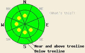
Near and above treeline, avalanche danger is LOW with pockets of MODERATE danger on SE-S-SW-W-NW-N aspects, 37 degrees and steeper. Below treeline, avalanche danger is LOW. |
|
|
|
Sunny skies, below average air temperatures, and a strong northeast wind event are forecast for the next several days. A low pressure system will move south today along the NV/UT boarder. The forecast area will be right between the axis of high pressure off shore and the center of low pressure to the east. Cold air will move across the pressure gradient and into the area. Air temperatures today above 7,000' are unlikely to warm and may possibly cool with maximum daytime air temperatures in the mid teens to low 20s expected. Ridgetop winds remain moderate in speed out of the east northeast this morning. Winds are forecast to increase in speed this afternoon with strong gusts expected.
Observations made yesterday on Hidden Peak (West Shore Tahoe area) and near Tortilla Cliffs (closed unskied terrain at the Bear Valley Ski Area) both reveled significant redistribution of Sunday's storm snow. ENE winds had scoured NE-E aspects in near and above treeline areas and deposited 10 to 24 inches of wind loaded snow onto SE-S-SW-W-NW-N aspects. Snowpit data obtained along the summit ridge of Hidden Peak (SE aspect at 9,150') and near Tortilla Cliffs (N aspect at 7,450') noted higher density winds slabs 10 to 14 inches thick on top of 8 to 10 inches of lower density storm snow (pit profiles, photos, more info). Some minor skier triggered cracking of these slabs was observed along the summit ridge of Hidden Peak while more significant skier triggered cracking and snow pit tests indicating likely fracture propagation of wind slabs was noted in the Tortilla Cliffs area. The Tortilla Cliffs area is inside the ski area boundary, but it has remained closed for the past week and was very representative of the backcountry terrain adjacent to the ski area boundary at the time the data was obtained. Observations made on Castle Peak (Donner Summit area) did not reveal the wind slab formation or evidence of instability that was observed in other areas (more info).
Primary Avalanche Concern: Wind Slabs
Ongoing and increasing NE winds still have plenty of snow available for wind transport. Continued redistribution of recent storm snow and wind loading on SE-S-SW-W-NW-N aspects is expected to occur near and above treeline. Pockets of existing unstable wind slabs will increase in size today, especially once ridgetop winds increase this afternoon. In some areas only wind pillows too small to pose a significant threat to backcountry travelers have formed. In other areas where more efficient wind loading and/or cross loading occurs, larger wind slabs and human triggered avalanches large enough to bury or injure a person are possible today.
Near and above treeline, avalanche danger is LOW with pockets of MODERATE danger on SE-S-SW-W-NW-N aspects, 37 degrees and steeper. Below treeline, avalanche danger is LOW.
| 0600 temperature: | 18 to 21 deg. F. |
| Max. temperature in the last 24 hours: | 28 to 34 deg. F. |
| Average wind direction during the last 24 hours: | East northeast |
| Average wind speed during the last 24 hours: | 29 mph |
| Maximum wind gust in the last 24 hours: | 45 mph |
| New snowfall in the last 24 hours: | O inches |
| Total snow depth: | 62 to 90 inches |
For 7000-8000 ft: |
|||
| Tuesday: | Tuesday Night: | Wednesday: | |
| Weather: | Sunny skies. | Clear skies. | Sunny skies. |
| Temperatures: | 18 to 25 deg. F. | 3 to 10 deg. F. | 26 to 33 deg. F. |
| Wind direction: | NE | NE | E |
| Wind speed: | 10 to 20 mph with gusts to 35 mph. | 15 to 25 mph with gusts to 40 mph. | 10 to 20 mph with gusts to 35 mph. |
| Expected snowfall: | O in. | O in. | O in. |
For 8000-9000 ft: |
|||
| Tuesday: | Tuesday Night: | Wednesday: | |
| Weather: | Sunny skies. | Clear skies. | Sunny skies. |
| Temperatures: | 14 to 21 deg. F. | 9 to 15 deg. F. | 22 to 29 deg. F. |
| Wind direction: | NE | E | E |
| Wind speed: | 25 to 35 mph with gusts to 50 mph in the morning. Winds increasing to 35 to 45 mph with gusts to 70 mph in the afternoon. | 30 to 50 mph with gusts to 85 mph. Gusts decreasing to 70 mph after midnight. | 30 to 45 mph with gusts to 70 mph in the morning. Winds decreasing to 25 to 35 mph with gusts to 60 mph in the afternoon. |
| Expected snowfall: | O in. | O in. | O in. |


This website is owned and maintained by the non-profit arm of the Sierra Avalanche Center. Some of the content is updated by the USDA avalanche forecasters including the forecasts and some observational data. The USDA is not responsible for any advertising, fund-raising events/information, or sponsorship information, or other content not related to the forecasts and the data pertaining to the forecasts.

