In partnership with: 
|
February 8, 2011 at 7:47 am |
|
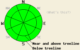
Avalanche danger is LOW for all elevations and aspects. Normal caution is advised.
|
|
|
|
Cold front passage through the forecast area occurred last night around 8 pm in the north and around 11 pm in the south. Behind the front, ridgetop winds shifted from west to northeast and air temperatures dropped. Winds speeds became light around the time of frontal passage, but have steadily increased through the early morning hours and become strong in speed. Most mid and upper elevation remote sensors are reporting air temperatures in the teens and single digits this morning. This is around 20 to 25 degrees colder than at this time yesterday morning. Partly cloudy skies, moderate to strong northeast to east winds, and the slight possibility of some very light upslope snow showers along the eastern edge of the forecast area are expected for today.
Observations made yesterday on Silver Peak (Pole Creek area), Tamarack Peak (Mount Rose area), and on Frog Lake Ridge (Carson Pass area) all showed continued evidence of stable snowpack conditions (photos, more info). Despite the recent strong winds, very little to no snow has been available for wind transport. Very small amounts of blowing snow with no lee side deposition were noted at times on Silver Peak and on Tamarack Peak, but was absent on Frog Lake ridge. Melting of surface snow on southerly aspects was kept to a minimum yesterday due to convective cooling from west winds. Areas above 9,200' were noted to remain frozen all day. Above treeline areas hold high density snow surfaces on all aspects created either by wind scouring on the W-NW-N-NE-E aspects or melt freeze on the E-SE-S-SW-W aspects. Below treeline on wind sheltered N aspects, a few inches of unconsolidated snow linger in many areas.
Avalanche concerns:
Avalanche concerns for today are few. Below freezing air temperatures at the mid and upper elevations will keep snow surface melting on southerly aspects limited to low elevation areas. Most southerly aspects are expected to remain frozen all day. Ridgetop winds have been strong and have shifted direction a couple of times in the past two days, but no significant amounts of snow have been available for transport. No new wind slab formation has occurred. Wind slabs that formed last week and held lingering instability on N-NW aspects are no longer showing signs of instability. Any form of human triggered avalanche activity is unlikely today. Any pockets of unstable snow that exist around the forecast area are very isolated at best. Exercise good travel habits to keep the odds stacked in favor of backcountry travelers.
| 0600 temperature: | 11 to 16 deg. F. |
| Max. temperature in the last 24 hours: | 39 to 47 deg. F. |
| Average wind direction during the last 24 hours: | West shifting to east |
| Average wind speed during the last 24 hours: | 45 mph |
| Maximum wind gust in the last 24 hours: | 87 mph |
| New snowfall in the last 24 hours: | O inches |
| Total snow depth: | 59 to 86 inches |
For 7000-8000 ft: |
|||
| Tuesday: | Tuesday Night: | Wednesday: | |
| Weather: | Becoming partly cloudy skies. | Partly cloudy skies in the evening, becoming clear. | Sunny skies. |
| Temperatures: | 22 to 29 deg. F. | 12 to 18 deg. F. | 24 to 31 deg. F. |
| Wind direction: | NE shifting to E | E | E |
| Wind speed: | 10 to 20 mph with gusts to 35 mph. Gusts increasing to 45 mph in the afternoon. | 10 to 20 mph with gusts to 40 mph. | 10 to 20 mph with gusts to 35 mph. |
| Expected snowfall: | O in. | O in. | O in. |
For 8000-9000 ft: |
|||
| Tuesday: | Tuesday Night: | Wednesday: | |
| Weather: | Becoming partly cloudy skies. | Partly cloudy skies in the evening, becoming clear. | Sunny skies. |
| Temperatures: | 16 to 23 deg. F. | 8 to 15 deg. F. | 19 to 26 deg. F. |
| Wind direction: | NE shifting to E | E | E |
| Wind speed: | 20 to 30 mph with gusts to 40 mph. Winds increasing to 30 to 45 mph with gusts to 55 mph in the afternoon. | 30 to 45 mph decreasing to 25 to 35 mph after midnight. Gusts to 60 mph. | 20 to 30 mph with gusts to 50 mph. |
| Expected snowfall: | O in. | O in. | O in. |


This website is owned and maintained by the non-profit arm of the Sierra Avalanche Center. Some of the content is updated by the USDA avalanche forecasters including the forecasts and some observational data. The USDA is not responsible for any advertising, fund-raising events/information, or sponsorship information, or other content not related to the forecasts and the data pertaining to the forecasts.

