In partnership with: 
|
February 15, 2011 at 7:51 am |
|
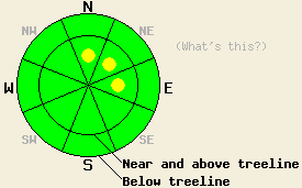
In most areas the avalanche danger remains LOW. Some isolated pockets of MODERATE avalanche danger may exist on the wind-loaded N-NE-E aspects near and above treeline 35 degrees and steeper. The avalanche danger will increase quickly and dramatically as a strong winter storm impacts the region this evening. |
|
|
|
A large low pressure system continues to advance on the forecast area. The southwest winds that have increased ahead of this system should remain strong with speeds averaging 50-75 mph and gusts up to 120 mph over the Sierra Crest. The forecast calls for snow showers to continue today without much accumulation until this evening when the storm really arrives. At that point snowfall rates should increase dramatically and continue through tomorrow. By tomorrow evening snow totals could reach 1-2 ft at Lake level and 3-5 ft. in the mountains above 7000 ft. As the low pressure and the cold front accompanying it arrive over the region tonight, temperatures should steadily fall during the night and into tomorrow. The forecast calls for daytime highs in the teens tomorrow (weather graphic from the Reno NWS).
More snow than forecasted fell in the last 24 hours. Remote sensors indicate that 1-3 inches of new snow fell along the Sierra Crest with only about 1 inch in the mountains east of Lake Tahoe. Observations yesterday on Andesite Ridge showed mostly "dust on crust" conditions on slopes sheltered from the winds. Near treeline on slopes exposed to the winds, wind scoured frozen crusts existed on the windward aspects, and very shallow (1-2 inches) wind-loading had occurred on the leeward aspects. The winds had formed some very small patches of slightly deeper (3-5 inches) wind slabs on these exposed N-NE aspects. In most areas ski cuts did not produce any failures. However, ski cuts placed at just the right spot on those patches of deeper wind slabs did cause small fractures that failed within the new snow (videos and photos). Hand pits showed only moderate bonding between the crusts and the new snow.
Primary Avalanche Concern: Wind Slabs
For most of the day in most areas dangerous avalanche activity should remain unlikely. Some small human trigger-able wind slabs may exist on pockets of terrain in the most heavily wind-loaded areas due to more than expected accumulation over the last 24 hours and strong southwest winds. Most of these slabs should not entrain enough snow to bury a person. However, these small isolated wind slabs combined with the hard frozen crusts in their runout zones could result in more serious consequences than would normally be expected of instabilities this size.
When it starts snowing more heavily this evening, larger, more dangerous avalanche activity will become possible on a wider variety of aspects and at more elevations. By late tonight and early tomorrow morning, natural avalanche activity could start to occur. If the this storm arrives sooner than forecasted, the avalanche danger will also increase sooner.
In most areas the avalanche danger remains LOW. Some isolated pockets of MODERATE avalanche danger may exist on the wind-loaded N-NE-E aspects near and above treeline 35 degrees and steeper. The avalanche danger will increase quickly and dramatically as a strong winter storm impacts the region this evening.
| 0600 temperature: | 24-26 deg. F. |
| Max. temperature in the last 24 hours: | 27-31 deg. F. |
| Average wind direction during the last 24 hours: | Southwest |
| Average wind speed during the last 24 hours: | 50-60 mph |
| Maximum wind gust in the last 24 hours: | 109 mph |
| New snowfall in the last 24 hours: | 1-3 inches |
| Total snow depth: | 57-83 inches |
For 7000-8000 ft: |
|||
| Tuesday: | Tuesday Night: | Wednesday: | |
| Weather: | Mostly cloudy with a chance of snow. | Snow. Temperatures falling through the night. | Snow |
| Temperatures: | 28-32 deg. F. | 20-24 deg. F. | 15-20 deg. F. |
| Wind direction: | Southwest | Southwest | South shifting to the southwest in the afternoon |
| Wind speed: | 30-45 mph with gusts to 70 mph | 35-45 mph with gusts to 75 mph | 25-35 mph with gusts to 55 mph decreasing to 15-25 mph with gusts to 40 mph in the afternoon |
| Expected snowfall: | 0-1 in. | 10-18 in. | 6-12 in. |
For 8000-9000 ft: |
|||
| Tuesday: | Tuesday Night: | Wednesday: | |
| Weather: | Mostly cloudy with a chance of snow. | Snow. Temperatures falling through the night. | Snow |
| Temperatures: | 26-30 deg. F. | 18-22 deg. F. | 10-15 deg. F. |
| Wind direction: | Southwest | Southwest | Southwest |
| Wind speed: | 55-75 mph with gusts to 100 mph increasing to 120 mph in the afternoon | 55-75 mph with gusts to 120 mph decreasing to 100 mph after midnight | 50-70 mph with gusts to 90 mph decreasing to 35-45 mph with gusts to 60 mph in the afternoon |
| Expected snowfall: | 0-1 in. | 12-24 in. | 10-18 in. |


This website is owned and maintained by the non-profit arm of the Sierra Avalanche Center. Some of the content is updated by the USDA avalanche forecasters including the forecasts and some observational data. The USDA is not responsible for any advertising, fund-raising events/information, or sponsorship information, or other content not related to the forecasts and the data pertaining to the forecasts.

