In partnership with: 
|
February 18, 2011 at 7:52 am |
|
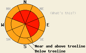
Near and above treeline, avalanche danger is HIGH on NW-N-NE-E-SE aspects, 35 degrees and steeper. Below treeline, avalanche danger is CONSIDERABLE on all aspects on slopes 35 degrees and steeper. |
|
|
|
A series of storm systems continues to impact the forecast area. After well above forecast snowfall amounts accumulated yesterday, new snow has continued overnight. New snow amounts for the past 48 hours are running 35 to 70 inches. New snow amounts for the past 24 hours are running 16 to 43 inches while new snow amounts for the past 12 hours are running 12 to 23 inches. Another deep trough of low pressure will move into the forecast area today causing another round of high intensity snowfall. A fair bit of warming will occur today as snow levels rise from near 2,000' up to around 4,000'. Ridgetop winds remain strong out of the southwest this morning. Winds are forecast to shift more to the south today and decrease to moderate to strong in speed. Maximum daytime air temperatures at 8,000' are expected to climb into the mid 20s today, around 5 degrees warmer than yesterday.
Observations made yesterday on Andesite Ridge (Donner Summit area) and on Tamarack Peak (Mount Rose area) revealed widespread instability within the new snow. On Andesite Ridge widespread cracking was observed in below treeline terrain on both steep and low angle slopes on all aspects. Slab failure was occurring in any areas with minimal to more pronounced wind effects on N-NE-E-SE-S aspects. In open terrain at treeline, shooting cracks and very easy stability test failures were very repeatable in wind loaded areas. Snowpack failure occurred on a density change within the new snow with slab depths from 6 to 10 inches in the more protected areas and most likely deeper in the more heavily wind loaded areas (more info, photo, pit profile, video). On the East ridge of Tamarack Peak, small soft slab avalanches were easy to intentionally initiate, even in areas with limited wind loading. Slab failure was noted to occur within the new snow around 8 inches deep. In lower angle areas with moderate wind effects, shooting cracks were common (photos, more info). No reports of natural avalanche activity occurring during the day yesterday have been received, but visibility has been very poor and access difficult.
Primary Avalanche Concern: Wind Slabs
Unstable slabs of wind loaded storm snow in lee areas remain the main concern for large destructive avalanches. A small decrease in wind speeds today will bring wind speeds into the range to very efficiently wind load near and above treeline avalanche start zones on NW-N-NE-E-SE aspects. Once avalanches initiate, there is a significant possibility that the slabs may step down to deeper layers within the storm snow or simply entrain much of the deeper storm snow. This could serve to greatly increase the size and destructive potential of any natural or human triggered avalanches that occur today.
Avalanche Concern #2: Storm Snow Instabilities
Yesterday's observations revealed very unstable instabilities within the storm snow. Slab failure was noted in areas with minimal wind effect. Some of this same instability may still exist today. As air temperatures warm today and snow level rises, a new upside-down surface slab is expected to form within the new snow regardless wind effects. Slab avalanche activity is possible today in steep areas below treeline, especially in response to human triggers. In very wind protected areas, loose snow avalanches may occur in steep areas, especially during the morning hours prior to the formation of a new upside-down surface slab.
Near and above treeline, avalanche danger is HIGH on NW-N-NE-E-SE aspects, 35 degrees and steeper. Below treeline, avalanche danger is CONSIDERABLE on all aspects on slopes 35 degrees and steeper.
| 0600 temperature: | 16 to 19 deg. F. |
| Max. temperature in the last 24 hours: | 20 to 21 deg. F. |
| Average wind direction during the last 24 hours: | Southwest |
| Average wind speed during the last 24 hours: | 50 mph |
| Maximum wind gust in the last 24 hours: | 104 mph |
| New snowfall in the last 24 hours: | 16 to 43 inches |
| Total snow depth: | 93 to 128 inches |
For 7000-8000 ft: |
|||
| Friday: | Friday Night: | Saturday: | |
| Weather: | Cloudy skies with high intensity snowfall. | Cloudy skies with snow. | Cloudy to mostly cloudy skies with snow showers likely. |
| Temperatures: | 24 to 28 deg. F. | 20 to 25 deg. F. | Daytime cooling with morning highs 20 to 25 deg. F. |
| Wind direction: | S to SW | S | W |
| Wind speed: | 10 to 15 mph with gusts to 30 mph. | 10 to 15 mph with gusts to 30 mph in the evening, becoming light. | 10 to 15 mph with gusts to 30 mph. |
| Expected snowfall: | 8 to 14 in. | 3 to 5 in. | Up to 2 in. |
For 8000-9000 ft: |
|||
| Friday: | Friday Night: | Saturday: | |
| Weather: | Cloudy skies with high intensity snowfall. | Cloudy skies with snow. | Cloudy to mostly cloudy skies with snow showers likely. |
| Temperatures: | 18 to 24 deg. F. | 16 to 22 deg. F. | Daytime cooling with morning highs 16 to 22 deg. F. falling to 8 to 14 deg. F. |
| Wind direction: | S to SW | S | SW |
| Wind speed: | 25 to 35 mph with gusts to 55 mph. | 20 to 25 mph with gusts to 40 mph. | 20 to 30 mph with gusts to 45 mph. |
| Expected snowfall: | 10 to 16 in. | 4 to 6 in. | Up to 4 in. |


This website is owned and maintained by the non-profit arm of the Sierra Avalanche Center. Some of the content is updated by the USDA avalanche forecasters including the forecasts and some observational data. The USDA is not responsible for any advertising, fund-raising events/information, or sponsorship information, or other content not related to the forecasts and the data pertaining to the forecasts.

