In partnership with: 
|
February 26, 2011 at 8:02 am |
|
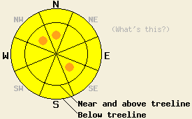
Near and above treeline, avalanche danger is MODERATE with pockets of CONSIDERABLE danger on cross loaded NW, N, and SE aspects, 35 degrees and steeper. Below treeline, avalanche danger is MODERATE on all aspects, 35 degrees and steeper. Large human triggered avalanches remain possible. |
|
|
|
The storm system that brought snow to the forecast area for the past two days has exited the region. Storm totals are running 21 to 40 inches along the Sierra Crest and 13 to 26 inches in the Carson Range. New snow amounts for the past 24 hours are running 11 to 21 inches across the forecast area. Ridgetop winds that were gale force in speed out of the southwest yesterday have become calm this morning. Winds are forecast to shift to the northeast to east today and increase to moderate in speed this afternoon. Air temperatures across the forecast area are in the single digits this morning with below 0 temperatures at the highest elevation sites. Partly cloudy skies, snow showers over the southern end of the forecast area, and maximum daytime air temperatures in the single digits and teens are expected for today. Another chilly night tonight followed by significant warming is expected for tomorrow.
A number of natural and human trigger avalanches were reported to have occurred in the backcountry yesterday, but in most cases details are few. Natural avalanches were reported in the Donner Summit (more info), Carson Pass, and Mount Rose areas all in near treeline to above treeline terrain that receives wind loading from southwest winds. At mid day, a skier triggered avalanche was reported to have occurred above the Mount Rose Highway at 8,000' on a E to SE aspect avalanche path know locally as "Barney's". The avalanche measured 250' wide with a crown depth of 2'. The avalanche buried both lanes of Hwy 431. No one was caught in the avalanche.
Observations made below treeline on Trimmer Peak (Luther Pass area) on NW-N-NE aspects between 6,500' and 9,000' and on Hidden Peak (West Shore Tahoe area) on NE-E aspects between 6,600' and 8,000' revealed strong winds and significant wind transport of snow in below treeline areas. An upside down snowpack was noted with the storm snow due to warming air temperatures. Skier triggered cracking was widespread. Ski cuts on steep convex test slopes in wind loaded areas produced slab failure within the new snow. Stability tests indicated that significant instabilities existed within the new snow capable of leading to either slab or loose snow avalanches depending on the amount of wind loading in the vicinity. One test result on Trimmer Peak indicating slab failure was observed to initiate within the new snow and then step down below the old/new snow interface into lower density snow that formed during last week's storm cycle. For photo, video, and more info from Trimmer Peak click here. For photo, video, and more info from Hidden Peak click here. Observations and snowpit data collected in Negro Canyon (Donner Summit area) on a SW aspect at 6,450' revealed wind transport of snow below treeline with less slab formation within the new snow (pit profile, photos, more info).
Primary Avalanche Concern: Storm snow slabs and wind slabs
All of the reported avalanche activity from yesterday was noted to have occurred within the new snow. Unstable slabs formed yesterday from both wind loading and warming air temperatures that deposited higher density snow on top of lower density snow. Cold air temperature last night and today are expected to slow down the rate of storm snow stabilization allowing for ongoing instability, especially in response to human triggers. As ridgetop winds increase in speed and shift to the east today, a new round of wind loading and cross loading is expected to occur. The greatest areas of concern exist near and above treeline on cross loaded NW, N, and SE aspects that also received significant wind loading yesterday.
Secondary Avalanche Concern: Deep slabs
Prior to significant snowfall over the past 36 hours, unstable wind slabs had been observed near and above treeline on N-NE aspects. These wind slabs which were already unstable prior to this storm cycle have received significant additional loading. Failure of these slabs would lead to deep slab instability with snowpack failure occurring 1 to 3 feet below the old/new snow interface. In many areas these wind slabs had taken on hard slab characteristics prior to becoming buried. This could allow a person to get further out onto the slab before failure occurs or for more than one person to travel the slope before a deep slab avalanche occurs. Avalanche activity that initiates within the recent storm snow may step down to the lower density snow below these wind slabs, drastically increasing the size and destructive potential of the avalanche.
Near and above treeline, avalanche danger is MODERATE with pockets of CONSIDERABLE danger on cross loaded NW, N, and SE aspects, 35 degrees and steeper. Below treeline, avalanche danger is MODERATE on all aspects, 35 degrees and steeper. Large human triggered avalanches remain possible.
| 0600 temperature: | 0 to 3 deg. F. |
| Max. temperature in the last 24 hours: | 18 to 22 deg. F. |
| Average wind direction during the last 24 hours: | Southwest |
| Average wind speed during the last 24 hours: | 55 mph |
| Maximum wind gust in the last 24 hours: | 139 mph |
| New snowfall in the last 24 hours: | 11 to 21 inches |
| Total snow depth: | 97 to 144 inches |
For 7000-8000 ft: |
|||
| Saturday: | Saturday Night: | Sunday: | |
| Weather: | Partly cloudy skies with scattered snow showers south of Lake Tahoe in the afternoon. | Partly cloudy skies. | Sunny skies. |
| Temperatures: | 11 to 17 deg. F. | 3 to 8 deg. F. | 30 to 35 deg. F. |
| Wind direction: | E | NE | SW |
| Wind speed: | Light winds increasing to around 10 mph with gusts to 25 mph in the afternoon. | 10 to 15 mph with gusts to 30 mph. | Light winds increasing to around 10 mph in the afternoon. |
| Expected snowfall: | 0 to trace in. | O in. | O in. |
For 8000-9000 ft: |
|||
| Saturday: | Saturday Night: | Sunday: | |
| Weather: | Partly cloudy skies with scattered snow showers south of Lake Tahoe in the afternoon. | Mostly cloudy skies with isolated snow showers in the evening, becoming partly cloudy. | Sunny skies. |
| Temperatures: | 5 to 11 deg. F. | 5 to 10 deg. F. | 25 to 30 deg. F. |
| Wind direction: | E | NE | NW shifting to W |
| Wind speed: | Light winds increasing to 10 to 20 mph with gusts to 30 mph in the afternoon. | 20 to 30 mph with gusts to 40 mph. | 10 to 20 mph increasing to 20 to 30 mph with gusts to 35 mph in the afternoon. |
| Expected snowfall: | 0 to trace in. | 0 to trace in. | O in. |


This website is owned and maintained by the non-profit arm of the Sierra Avalanche Center. Some of the content is updated by the USDA avalanche forecasters including the forecasts and some observational data. The USDA is not responsible for any advertising, fund-raising events/information, or sponsorship information, or other content not related to the forecasts and the data pertaining to the forecasts.

