In partnership with: 
|
February 28, 2011 at 8:00 am |
|
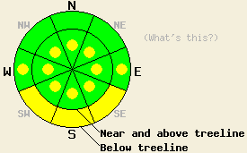
Near and above treeline, pockets of MODERATE avalanche danger will exist on all aspects, 35 degrees and steeper. Below treeline, avalanche danger is MODERATE on SE-S-SW aspects with pockets of MODERATE danger on E and W aspects, 35 degrees and steeper. Deep and destructive human triggered avalanches remain possible. |
|
|
|
The sunny, clear weather should continue while the high pressure ridge rests over the region. Temperatures should again climb into the upper 20's and low 30's above 7000 ft today. A low pressure system moving into the northwest should bring increased southwest winds to the area over the next 24 hours. It may even push some high clouds into the area; however, the precipitation associated with this system should remain well north of the forecast area.
A snowboarder triggered avalanche occurred on a sun-exposed, S-SE facing slope above a cliff band on Ralston Peak yesterday. This avalanche carried one person. This slide resulted from rapid warming weakening the new snow to the point that the added weight of a person could break the bonds holding the storm snow to the snowpack. A sun crust that formed between the two storms last week served as the bed surface (photos and more info). Skier-triggered whumphing also occurred in this area as the interface between the crust and the snow above it failed on sun-exposed SE-S-SW aspects. On E-SE-S-SW aspects on Echo Peak, Red Lake Peak, Jake's Peak and on Slide Mt ( in the Mt. Rose area) some small loose point releases and roller balls occurred due to the rapid warming.
On the more northerly aspects observations showed a mostly stable snowpack that continues to gain strength. In the Bear Valley area and on Tamarack Peak stability tests showed continued settlement and consolidation within the storm snow. Ski cuts and cornices dropped onto the slopes below did not produce any fractures in the Tamarack Peak area.
More evidence of avalanche activity that occurred near the end of the storm on Friday continues to trickle in. New reports of old crowns on Incline Lake Peak, Ralston Peak, and in the Bear Valley area have come in.
Avalanche Concern #1: Warming Instabilities
Today's winds, some cloud cover, and the fact that the snow has already experienced some warming yesterday should help make warming instabilities less prevalent today. However, sunshine and daytime highs similar to yesterday should allow enough warming to occur for some of these instabilities to remain. As the snowpack weakens due to daytime warming, human-triggered avalanches will again become possible on the sun-exposed aspects where the most warming occurs. Most of these instabilities should manifest as point release avalanches and surface instabilities like roller balls; however, some slab avalanche activity will be possible as well. If slab avalanches do occur, they could be large, deep and dangerous. The mid to lower elevation SE-S-SW aspects will hold the best potential for these kinds of slides with pockets of these instabilities existing on other less sun-exposed aspects and on higher elevation sun-exposed aspects.
Avalanche Concern #2: Wind Slabs and Deep Slabs
Increased southwest winds last night and today could deposit enough snow onto the leeward aspects to form new small wind slabs. These slabs sit on top of the wind slabs that formed during the recent storm on the wind-loaded NW-N-NE-E-SE aspects. Observations show that in most areas the snowpack has strengthened enough to support these wind slabs. However, this strengthening has not occurred everywhere. The combination of old wind slabs and new ones that may form will keep human-triggered avalanches due to wind slab failure possible today. Pockets of unstable wind slabs may exist on the wind-loaded N-NE-E and cross-loaded NW and SE aspects near and above treeline. These pockets will be more likely in complex or extreme terrain. Even though these slabs may be more difficult to trigger today, avalanches resulting from failure of these slabs could be large, deep, and destructive and could step down into older snow causing deep slab avalanches. Larger triggers like large cornices or multiple people on a slope will have better chances of causing avalanche activity.
Near and above treeline, pockets of MODERATE avalanche danger will exist on all aspects, 35 degrees and steeper. Below treeline, avalanche danger is MODERATE on SE-S-SW aspects with pockets of MODERATE danger on E and W aspects, 35 degrees and steeper. Deep and destructive human triggered avalanches remain possible.
| 0600 temperature: | 11-18 deg. F. |
| Max. temperature in the last 24 hours: | 27-34 deg. F. |
| Average wind direction during the last 24 hours: | Northeast until midday yesterday then southwest |
| Average wind speed during the last 24 hours: | Northeast: 1-15 mph Southwest: 35-45 mph |
| Maximum wind gust in the last 24 hours: | Along the crest 47 mph, In the Mt. Rose area 81 mph |
| New snowfall in the last 24 hours: | O inches |
| Total snow depth: | 91-136 inches |
For 7000-8000 ft: |
|||
| Monday: | Monday Night: | Tuesday: | |
| Weather: | Mostly sunny | Mostly clear with some thin high clouds | Mostly sunny with some thin high clouds |
| Temperatures: | 28-35 deg. F. | 16-22 deg. F. | 35-40 deg. F. |
| Wind direction: | Southwest | Southwest | South |
| Wind speed: | 15-25 mph with gusts to 40 mph | 15-25 mph with gusts to 40 mph decreasing to 10-15 mph with gusts to 30 mph | 10-15 mph with gusts to 30 mph |
| Expected snowfall: | O in. | O in. | O in. |
For 8000-9000 ft: |
|||
| Monday: | Monday Night: | Tuesday: | |
| Weather: | Mostly sunny | Mostly clear with some thin high clouds | Mostly sunny with some thin high clouds |
| Temperatures: | 21-28 deg. F. | 20-24 deg. F. | 27-34 deg. F. |
| Wind direction: | Southwest | Southwest | South |
| Wind speed: | 25-40 mph with gusts to 75 mph decreasing to 20-35 mph with gusts to 65 mph in the afternoon | 20-35 mph with gusts to 60 mph decreasing to gusts to 50 mph | 20-35 mph with gusts to 50 mph |
| Expected snowfall: | O in. | O in. | O in. |


This website is owned and maintained by the non-profit arm of the Sierra Avalanche Center. Some of the content is updated by the USDA avalanche forecasters including the forecasts and some observational data. The USDA is not responsible for any advertising, fund-raising events/information, or sponsorship information, or other content not related to the forecasts and the data pertaining to the forecasts.

