In partnership with: 
|
March 12, 2011 at 8:00 am |
|
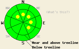
Near and above treeline, avalanche danger is LOW with pockets of MODERATE danger on NW-N-NE-E-SE aspects on slopes 37 degrees and steeper. Below treeline LOW avalanche danger exists on all aspects. |
|
|
|
More cloud cover and southwest winds should impact the forecast area today as another weak low pressure passes north of the region. Again, any precipitation from this system should stay north of the Central Sierra. By tonight the winds should start to decrease as a small high pressure ridge builds over the area. This ridge should only last through tomorrow morning before another low pressure begins to influence the weather. This low pressure should cause an increase in southwest winds and more clouds by tomorrow afternoon. A chance of snow could also develop during the day tomorrow; however, most precipitation associated with this low should not arrive till Sunday evening and night.
Yesterday dense, hard wind slabs existed on near and above treeline wind-loaded slopes on Jake's Peak and on Mt. Houghton (in the Mt. Rose area). In both of these areas, some skier-triggered cracking occurred in these wind slabs. The cracks on Jake's remained small and limited (more info), while on Houghton larger skier-triggered cracking occurred (photos). Stability tests on the interface between the hard wind slab and the softer snow below it on Jake's showed that fractures remain possible on this interface; however, they require more force to trigger. On Mt. Houghton the depth of the snowpack varied greatly, and in the shallow areas a layer of weak, sugary snow grains existed near the base of the snowpack (pit profile and more info).
On the snow surface, a firm, frozen crust existed on the northerly aspects up to 8000 ft and on the southerly aspects above 8000 ft on Jake's Peak. This crust had softened some below 8000 ft on the southerly aspects by noon; however, below 7300 ft the snow had already become wet and sticky by that time. On northerly aspects above 8000 ft, the crust gave way to firm snow and hard wind slabs in wind exposed areas.
Primary Avalanche Concern: Hard Wind Slabs
Dense, hard wind slabs resting on softer snow linger in the most wind-loaded areas. Observations show that these slabs are becoming more difficult to trigger; however, human activity could still break the bonds holding these slabs to the snow below them in some pockets of terrain. The most fragile wind slabs will exist in steep, wind-loaded complex and extreme terrain near and above treeline especially in areas with unsupported wind-loaded slopes. The NW-N-NE-E-SE aspects where the most recent wind loading has occurred will hold the largest of these slabs. These slabs exhibit hard slab characteristics meaning that they are more likely to break above the person who triggers them and could break after several people have already weighted the slope. Larger triggers like multiple people on a slope or large cornices will have better chances of causing avalanche activity. Even though these slabs should remain limited to pockets of terrain, they could have serious consequences if they do break. Use caution and evaluate slopes carefully before committing to them especially in areas where these hard slabs exist.
Near and above treeline, avalanche danger is LOW with pockets of MODERATE danger on NW-N-NE-E-SE aspects on slopes 37 degrees and steeper. Below treeline LOW avalanche danger exists on all aspects.
| 0600 temperature: | 20-28 deg. F. |
| Max. temperature in the last 24 hours: | 28-38 deg. F. |
| Average wind direction during the last 24 hours: | Southwest |
| Average wind speed during the last 24 hours: | 35 mph |
| Maximum wind gust in the last 24 hours: | 66 mph |
| New snowfall in the last 24 hours: | O inches |
| Total snow depth: | 91-129 inches |
For 7000-8000 ft: |
|||
| Saturday: | Saturday Night: | Sunday: | |
| Weather: | Mostly cloudy | Mostly cloudy | Cloudy with a chance of snow |
| Temperatures: | 34-42 deg. F. | 24-30 deg. F. | 32-38 deg. F. |
| Wind direction: | Southwest | Southwest | Southwest |
| Wind speed: | 15-20 mph with gusts to 35 mph | 15-20 mph with gusts to 35 mph decreasing to 10-15 mph after midnight | 15-20 mph with gusts to 35 mph increasing to 20-25 mph with gusts to 50 mph in the afternoon |
| Expected snowfall: | O in. | O in. | O in. |
For 8000-9000 ft: |
|||
| Saturday: | Saturday Night: | Sunday: | |
| Weather: | Mostly cloudy | Mostly cloudy | Cloudy with a chance of snow |
| Temperatures: | 24-32 deg. F. | 24-30 deg. F. | 26-32 deg. F. |
| Wind direction: | Southwest | Southwest | Southwest |
| Wind speed: | 25-35 mph with gusts to 55 mph | 25-35 mph with gusts to 55 mph decreasing to 15-25 mph with gusts to 35 mph after midnight | 25-35 mph with gusts to 55 mph increasing to 45-55 mph with gusts to 80 mph in the afternoon |
| Expected snowfall: | O in. | O in. | O in. |


This website is owned and maintained by the non-profit arm of the Sierra Avalanche Center. Some of the content is updated by the USDA avalanche forecasters including the forecasts and some observational data. The USDA is not responsible for any advertising, fund-raising events/information, or sponsorship information, or other content not related to the forecasts and the data pertaining to the forecasts.

