In partnership with: 
|
March 14, 2011 at 6:45 am |
|
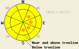
Near and above treeline avalanche danger is MODERATE with pockets of CONSIDERABLE danger on NE-E-SE-S aspects, on slopes 35 degrees and steeper. Below treeline, avalanche danger is MODERATE on all aspects on slopes 35 degrees and steeper. |
|
|
|
The storm system that impacted the forecast area yesterday and last night has exited the region this morning. New snow amounts from the last 16 hours are running 7 to 14 inches with the greatest accumulations in the northern half of the forecast area. Snow level appears to have stayed at or below 7,000' for nearly all of this event with significant accumulation above 6,500' in many areas. Ridgetop winds shifted to west this morning and have yet to decrease in speed. Ongoing moderate to strong ridgetop winds are expected through tomorrow. Air temperatures are falling this morning behind cold front passage, but will begin to warm by sunrise. Near to above freezing air temperatures are expected for most locations today. Ongoing snow shower activity is possible along the Sierra Crest, with decreasing cloud cover elsewhere. Another storm system is expected to move into the area sometime tomorrow.
Observations made yesterday on Silver Peak (Pole Creek area) and in Horse Canyon (Bear Valley area) indicated that the existing snowpack was in good condition to handle new snow loading. On Silver Peak, stable snow was noted on all aspects in below treeline and near treeline areas traveled up to 8,000'. Some minor wind transport of snow prior to the onset of significant snowfall was observed. New snow crystals early in the event were noted as needles and rimed crystals which often produce weak layers within storm snow (photo, video, pit profile, more info). In Horse Canyon, snowpit data indicating stable snowpack conditions was obtained near treeline at 7,600' on a NW aspect 35 degree slope (more info).
The vast majority of new snow accumulated after 6 to 9pm last night. During that time, remote sensors reported warming air temperatures for the first few hours of snowfall prior to decreasing air temperatures for the remainder of the snowfall event. This is expected to have created a section of lower density snow at the base of the storm snow layer. In some areas this lower density layer may be subtle, but it is still expected to act as a weak layer today.
Primary Avalanche Concern: Storm snow instability
Snowpack failure within the new snow is the main concern for today. Wind loaded areas near and above treeline will hold the greatest potential for slab avalanche activity today. Ongoing natural avalanche activity during the day today is expected to be isolated at best, but human triggered avalanches are likely. Steep open areas below treeline will also hold potential for human triggered slab avalanches, especially if wind loaded. Ongoing wind transport of snow by west winds today is expected to contribute to ongoing instability on NW-N-NE-E-SE-S aspects. Snowpack failure up to 3 feet deep is possible in wind loaded areas.
Secondary Avalanche Concern: Warming instability
As cloud cover decreases today, some amount of warming instability will occur. This is certainly expected in lower elevation areas and may occur in upper elevation areas as well. The degree to which cloud cover decreases today along the Sierra Crest will play a major roll in how much warming instability occurs in wind loaded near treeline terrain in the 7,000' to 9,000' elevation zone. With winds shifting to the west near the end of this storm cycle, more wind loaded snow will have been deposited on E-SE-S aspects. Wind loading and cross loading on these aspects will make them more susceptible to warming instability today. In the Carson Range, less cloud cover is expected today with good chances for warming instability to occur.
Near and above treeline avalanche danger is MODERATE with pockets of CONSIDERABLE danger on NE-E-SE-S aspects, on slopes 35 degrees and steeper. Below treeline, avalanche danger is MODERATE on all aspects on slopes 35 degrees and steeper.
| 0600 temperature: | 23 to 28 deg. F. |
| Max. temperature in the last 24 hours: | 28 to 34 deg. F. |
| Average wind direction during the last 24 hours: | Southwest |
| Average wind speed during the last 24 hours: | 45 mph |
| Maximum wind gust in the last 24 hours: | 89 mph |
| New snowfall in the last 24 hours: | 7 to 14 inches |
| Total snow depth: | 100 to 140 inches |
For 7000-8000 ft: |
|||
| Monday: | Monday Night: | Tuesday: | |
| Weather: | Mostly to partly cloudy skies. Numerous snow showers in the morning. Isolated snow showers in the afternoon. | Mostly cloudy skies with a slight chance of snow. | Cloudy skies with a chance of snow in the morning. Snow and rain in the afternoon. Snow level 7,500'. |
| Temperatures: | 33 to 38 deg. F. | 22 to 28 deg. F. | 37 to 42 deg. F. |
| Wind direction: | W | W | SW |
| Wind speed: | 10 to 20 mph with gusts to 40 mph. | 10 to 15 mph with gusts to 30 mph. | 10 to 15 mph with gusts to 35 mph. Winds increasing to 20 to 30 mph with gusts to 45 mph in the afternoon. |
| Expected snowfall: | Up to 1 in. | 0 to trace in. | Up to 2 in. |
For 8000-9000 ft: |
|||
| Monday: | Monday Night: | Tuesday: | |
| Weather: | Mostly to partly cloudy skies. Numerous snow showers in the morning. Isolated snow showers in the afternoon. | Mostly cloudy skies with a slight chance of snow. | Cloudy skies with a chance of snow in the morning. Snow in the afternoon. |
| Temperatures: | 28 to 32 deg. F. | 19 to 24 deg. F. | 29 to 34 deg. F. |
| Wind direction: | W | W | SW |
| Wind speed: | 30 to 45 mph with gusts to 65 mph. | 20 to 30 mph with gusts to 50 mph. | 25 to 35 mph with gusts to 65 mph. Winds increasing to 45 to 55 mph with gusts to 85 mph in the afternoon. |
| Expected snowfall: | Up to 1 in. | 0 to trace in. | Up to 2 in. |


This website is owned and maintained by the non-profit arm of the Sierra Avalanche Center. Some of the content is updated by the USDA avalanche forecasters including the forecasts and some observational data. The USDA is not responsible for any advertising, fund-raising events/information, or sponsorship information, or other content not related to the forecasts and the data pertaining to the forecasts.

