In partnership with: 
|
March 16, 2011 at 6:53 am |
|
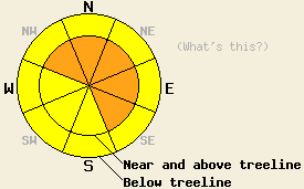
Near and above treeline, avalanche danger is CONSIDERABLE on NW-N-NE-E-SE aspects, on slopes 35 degrees and steeper. Below treeline, avalanche danger is MODERATE in open areas, on slopes 35 degrees and steeper. Large destructive avalanches are possible. |
|
|
|
The current storm system is expected to provide a few more hours of high intensity snowfall through this morning, before decreasing to snow showers this afternoon. Remote sensors above 8,000' are reporting 24 hour new snow amounts of 12 to 15 inches in the southern half of the forecast area and 17 to 21 inches in the northern half of the forecast area. Nearly all of the new snow has accumulated during the last 16 hours. An additional 4 to 10 inches of new snow is expected to accumulate this morning above 7,000'. Ridgetop winds remain strong in speed this morning. Wind direction shifted slightly back and forth overnight between southwest and west. Continued strong southwest to west winds are expected through this morning before winds ease to moderate in speed this afternoon.
During the day yesterday snow level was much slower to rise than anticipated, leading to better than expected snowpack stability. Of all of the observations made yesterday, those on Donner Pass (Donner Summit area) held the only significant indicators of snowpack instability. In this area snowfall rates were in excess of 1 inch per hour with strong winds for much of the mid day hours. Skier triggered shooting cracks up to 6 feet in length were common in wind loaded areas. Snowpit data collected at 7,500' in near treeline terrain on a N aspect did not provide any additional evidence of instability (photo, video, more info). Observations made yesterday on Rose Knob Peak (Mount Rose area), Frog Lake Ridge (Carson Pass area), and on Forestdale Knob (Carson Pass area) all gave indications of a stable snowpack (for pit profiles, photos, and more info, click here).
Most of the new snowfall occurred after 4pm yesterday and after the above field observations were made. Remote sensors indicate an air temperature increase that took place between 7pm and 9pm in most areas. This is likely to have added a relative weak layer of lower density snow within the lower third of last night's storm snow.
Primary Avalanche Concern: Storm snow slab avalanches in wind loaded areas
Air temperatures have been on a cooling trend since around 8 to 9pm last night. This is expected to have deposited lower density snow on top of higher density snow within the top 2/3rds of the new snow. Last night's temperature spike is expected to have placed a lower density layer near the base of the new snow that may act as a weak layer today. This will be most pronounced in areas where the slab characteristics of the top 2/3rds of the new snow have been enhanced by wind loading. Slab failure several feet deep is possible in the most heavily wind loaded areas near and above treeline on NW-N-NE-E-SE aspects. Smaller slab avalanches are possible below treeline in open wind loaded areas. Natural avalanches will remain possible through the morning hours during the expected period of high intensity snowfall. Human triggered avalanches will remain possible all day long.
Secondary Avalanche Concern: Loose snow avalanches
In wind protected areas below treeline where slab characteristics are minimal, human triggered loose snow avalanches involving the top several inches of new snow are possible. This will mainly be confine to slopes and slope micro features 37 degrees and steeper. The main hazard presented by this avalanche type will be to push people off course towards secondary terrain features such trees and cliffs.
Near and above treeline, avalanche danger is CONSIDERABLE on NW-N-NE-E-SE aspects, on slopes 35 degrees and steeper. Below treeline, avalanche danger is MODERATE in open areas, on slopes 35 degrees and steeper. Large destructive avalanches are possible.
| 0600 temperature: | 25 to 32 deg. F. |
| Max. temperature in the last 24 hours: | 31 to 38 deg. F. |
| Average wind direction during the last 24 hours: | West Southwest |
| Average wind speed during the last 24 hours: | 55 mph |
| Maximum wind gust in the last 24 hours: | 86 mph |
| New snowfall in the last 24 hours: | 12 to 21 inches |
| Total snow depth: | 110 to 158 inches |
For 7000-8000 ft: |
|||
| Wednesday: | Wednesday Night: | Thursday: | |
| Weather: | Cloudy skies with snow in the morning. Snow showers in the afternoon. | Mostly cloudy skies with scattered snow showers in the evening. | Partly cloudy skies in the morning, becoming mostly cloudy. |
| Temperatures: | 28 to 32 deg. F. | 9 to 16 deg. F. | 28 to 34 deg. F. |
| Wind direction: | SW | SW | SW |
| Wind speed: | 20 to 30 mph with gusts to 45 mph. | 10 to 15 mph with gusts to 35 mph. | 10 to 20 mph with gusts to 40 mph. |
| Expected snowfall: | 4 to 8 in. | Trace to 1 in. | O in. |
For 8000-9000 ft: |
|||
| Wednesday: | Wednesday Night: | Thursday: | |
| Weather: | Cloudy skies with snow in the morning. Snow showers in the afternoon. | Mostly cloudy skies with scattered snow showers in the evening. | Partly cloudy skies in the morning, becoming mostly cloudy. |
| Temperatures: | 24 to 28 deg. F. | 7 to 12 deg. F. | 23 to 27 deg. F. |
| Wind direction: | SW | SW | SW |
| Wind speed: | 35 to 50 mph with gusts to 85 mph. Winds decreasing to 25 to 35 mph with gusts to 55 mph in the afternoon. | 25 to 40 mph with gusts to 55 mph. Winds decreasing to 20 to 30 mph with gusts to 45 mph after midnight. | 20 to 35 mph with gusts to 50 mph. |
| Expected snowfall: | 5 to 10 in. | Trace to 1 in. | O in. |


This website is owned and maintained by the non-profit arm of the Sierra Avalanche Center. Some of the content is updated by the USDA avalanche forecasters including the forecasts and some observational data. The USDA is not responsible for any advertising, fund-raising events/information, or sponsorship information, or other content not related to the forecasts and the data pertaining to the forecasts.

