In partnership with: 
|
March 18, 2011 at 7:01 am |
|
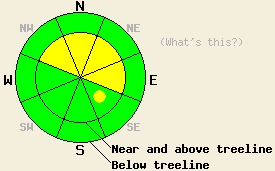
Near and above treeline by this afternoon, MODERATE avalanche danger will form on NW-N-NE-E aspects steeper than 35 degrees with pockets of MODERATE danger on the SE aspects. Below treeline the avalanche danger should remain LOW during the day today. As the winter storm impacts the forecast area, CONSIDERABLE avalanche danger will develop in areas at all elevations tonight. If the storm arrives sooner than expected, the areas of CONSIDERABLE danger will form sooner. |
|
|
|
A strong, cold low-pressure system should start to move into the area today bringing a cold winter storm with it. Temperatures should start to fall this afternoon and dive into the single digits and teens above 7000 ft tonight. Tomorrow's highs should only reach into the low to mid 20's above 7000 ft. The southwest winds have already started to increase along the Sierra Crest ahead of this system. As this system approaches this morning, snow showers could also begin. By later this afternoon, the snowfall should become more intense with 4-6 inches of new snow falling before 6pm. Most of the snow associated with this system should occur tonight with 10-20 inches of snow forecasted. Snowfall rates during this storm could easily reach 2-3 inches per hour. By tomorrow the winds and snowfall should start to slow down as the system moves on. For more information on this storm click here.
Yesterday in the Mt. Rose backcountry, a skier-triggered avalanche occurred on a wind-loaded, NE facing, near treeline, 40 degree slope at about 9400 ft. This slide measured about 1 ft in depth and was about 90 ft wide. It carried the skier who triggered it downhill for about 90 ft and continued to run for another 40 ft downhill. It did not result in any injuries.
On Incline Lake Peak also in the Mt. Rose backcountry, some minor cracking occurred on wind-loaded test slopes; however, stability tests, ski cuts and cornice "bombs" all showed mostly stable results (photos, more info). Father south on Porcupine Ridge (south of Heavenly) minor cracking and small fractures on undercut slopes remained limited to small wind-loaded areas near ridgelines. Just downhill from these areas, stability tests and ski cuts showed mostly stable snow (photos, more info). On the other side of the Lake, observations from Maggie's Peak also showed mostly stable conditions with some minor cracking near the ridgelines. Ski cuts on steep slopes in this area also did not produce any fractures (more info). On Andesite Ridge similar conditions existed. Ski cuts and cornice pieces dropped on wind-loaded slopes also did not produce any avalanche activity (photos, more info). On Andesite Ridge and on Maggie's snowpits and hand pits still showed a lighter, less dense layer of snow below a heavier layer of snow; however, stability tests on this interface showed that these bonds had gained some strength (snowpit from Andesite). Settlement cones around trees on Andesite Ridge (photo) and most remote sensors indicated at least 4-6 inches of consolidation in the snowpack since the storm. Out of all of these areas, only sun-exposed slopes on Andesite Ridge showed signs of warming.
Backcountry travelers and observers also reported several natural avalanches that likely occurred on March 16th. Reports of these slides came in from Janine's Peak (largest), Donner Peak, Needle Peak, and on Andesite Ridge.
Avalanche Concern #1: Old and New Wind Slabs
Even though most observations pointed to continued strengthening of the bonds holding the old wind slabs to the snowpack, some of these older wind slabs could still break in response to the added weight of a person. Human-triggered avalanches involving these older wind slabs will remain possible this morning in isolated near and above treeline areas on steep wind-loaded N-NE-E aspects. Unsupported slopes and complex and extreme terrain hold the best potential for lingering instabilities this morning. As the winds transport more snow today, new wind slabs will also form on leeward slopes. These new wind slabs will form slowly this morning. By this afternoon when the snowfall rates increase, the new wind slabs will quickly increase in size and distribution. As they grow larger, they will become much more fragile, and any additional weight could break the bonds holding them in place. Tonight natural avalanches due to failure of these wind slabs will become possible. Large and destructive avalanches could result from failure of these new wind slabs and they could step down into older snow. The largest wind slabs will form on the wind-loaded N-NE-E and cross-loaded NW and SE aspects near and above treeline. Smaller but still dangerous wind slabs will form on lower elevation leeward aspects tonight.
Avalanche Concern #2: Storm Snow Weaknesses
As the storm impacts the forecast area this afternoon and tonight, the snow may fall faster than it can bond to itself and the snow below it. The weaknesses that form due to subtle changes in the storm conditions will allow avalanche activity to occur within the storm snow. This afternoon any of these kinds of instabilities should be limited to small sluffs. Soft slab avalanches will also become possible as more snow falls. Human triggering of these kinds of avalanches will become possible as the new snow accumulates. Some natural activity of this kind may become possible tonight.
The avalanche danger will rise quickly and dramatically as the winter storm impacts the area this afternoon and tonight. If the storm arrives earlier than forecasted, the avalanche danger will increase sooner.
Near and above treeline by this afternoon, MODERATE avalanche danger will form on NW-N-NE-E aspects steeper than 35 degrees with pockets of MODERATE danger on the SE aspects. Below treeline the avalanche danger should remain LOW during the day today. As the winter storm impacts the forecast area, CONSIDERABLE avalanche danger will develop in areas at all elevations tonight. If the storm arrives sooner than expected, the areas of CONSIDERABLE danger will form sooner.
| 0600 temperature: | 15-21 deg. F. |
| Max. temperature in the last 24 hours: | 20-29 deg. F. |
| Average wind direction during the last 24 hours: | Southwest |
| Average wind speed during the last 24 hours: | 35-40 mph |
| Maximum wind gust in the last 24 hours: | 79 mph |
| New snowfall in the last 24 hours: | O inches |
| Total snow depth: | 110-154 inches |
For 7000-8000 ft: |
|||
| Friday: | Friday Night: | Saturday: | |
| Weather: | Chance of snow this morning becoming more widespread this afternoon. | Snow | Snow showers |
| Temperatures: | 29-34 deg. F. | 10-17 deg. F. | 23-29 deg. F. |
| Wind direction: | South | South | Southwest |
| Wind speed: | 15-25 mph with gusts to 40 mph increasing to 25-35 mph with gusts to 60 mph in the afternoon | 20-30 mph with gusts to 60 mph decreasing to gusts to 40 mph after midnight | 10-20 mph with gusts to 40 mph decreasing to 30 mph in the afternoon |
| Expected snowfall: | up to 4 in. | 10-18 in. | 2-6 in. |
For 8000-9000 ft: |
|||
| Friday: | Friday Night: | Saturday: | |
| Weather: | Chance of snow this morning becoming more widespread this afternoon. | Snow | Snow showers |
| Temperatures: | 23-29 deg. F. | 5-12 deg. F. | 15-25 deg. F. |
| Wind direction: | South | South | Southwest |
| Wind speed: | 30-50 mph with gusts to 75 mph increasing to 90 mph in the afternoon | 30-50 mph with gusts to 90 mph decreasing to 60 mph after midnight | 20-35 mph with gusts to 60 mph decreasing to 45 mph in the afternoon |
| Expected snowfall: | up to 6 in. | 12-20 in. | 2-6 in. |


This website is owned and maintained by the non-profit arm of the Sierra Avalanche Center. Some of the content is updated by the USDA avalanche forecasters including the forecasts and some observational data. The USDA is not responsible for any advertising, fund-raising events/information, or sponsorship information, or other content not related to the forecasts and the data pertaining to the forecasts.

