In partnership with: 
|
March 20, 2011 at 7:00 am |
|
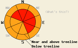
Near and above treeline, avalanche danger is HIGH on NW-N-NE-E-SE aspects, 35 degrees and steeper. Below treeline, avalanche danger is CONSIDERABLE in open areas on all aspects, 35 degrees and steeper. |
|
|
|
A deep lower pressure system moved into the forecast area last night following the previous storm system that exited the region yesterday afternoon. High intensity snowfall began again last night and is expected to continue through this evening. New snow amounts from the past 24 hours are running 13 to 17 inches along the Sierra Crest with around 5 inches in the Carson Range. Storm totals thus far are running 27 to 48 inches along the Sierra Crest and 12 to 17 inches in the Carson Range. An additional 8 to 18 inches of new snow is expected during the day today with the greatest accumulations south and west of Lake Tahoe. Ridgetop winds were moderate to strong out of the west for most of yesterday. Winds shifted to south and decreased to light in speed for a few hours overnight before shifting to southwest and increasing to strong in speed after midnight. Last night's south winds ushered in a few degrees of air temperature warming before the shift to southwest was accompanied by cooling air temperatures.
An intentional skier triggered avalanche occurred yesterday afternoon on Silver Peak (Pole Creek area) on a heavily wind loaded N aspect 38 degree slope in near treeline terrain at 7,930'. The avalanche was triggered from on top of the ridge in the upper edge of the wind loaded area. The slab initially failed as a 6 inch deep wind slab on top of lower density storm snow. The avalanche then proceeded to step down to up to 2 feet deep, but still within the wind loaded storm snow (photo, more info). Evidence of instability in this area was highly limited to very wind loaded areas. Shooting cracks were limited to the confines of directly wind loaded areas. No significant evidence of instability was seen away from cornice features and wind pillows. Below treeline, very minimal to no evidence of instability was observed. Ski cuts on steep convex test slopes on N-NE-E aspects yielded only sluffing of the top 2 inches of the storm snow. No cracking of any kind was observed. Settlement cones around trees on a N aspect at 7,700' revealed 2 inches of settlement at 3pm.
Observations made yesterday above Crystal Bay (Mount Rose area) revealed less evidence of instability, which was limited to minor cracking and obvious wind loading. Snowpit data obtained near treeline at 7,236' on a NE aspect showed a surface melt freeze crust on top of weaker old snow crystals. Good bonding was observed between this lower density snow and the wet snow grains below (pit profile, photo, video, more info). A few natural sluffs running up to 150 vertical feet appeared to have occurred in response to natural cornice collapse.
Avalanche Concern #1: Wind Slabs
New snow combined with shifting wind direction and changing wind speeds overnight are expected to have created new wind slabs on top of those that were formed yesterday. Large and destructive natural and human triggered avalanches are likely today near and above treeline in wind loaded areas with the greatest instability expected on NW-N-NE-E-SE aspects. This concern carries over into wind loaded areas below treeline as well. Wind loading from south winds overnight may place instability in some less common places. Once avalanches initiate within the top layers of the storm snow they may step down to deeper wind slab layers within the storm snow. Snowpack failure below the base of the total storm snow that has accumulated since Friday is not expected.
Avalanche Concern #2: Storm Snow Weaknesses
Changes in air temperature and snowfall intensity that occurred overnight and will continue to occur today will keep producing density changes and storm snow weaknesses. In wind protected areas, a fair amount of settlement from yesterday is expected to keep ongoing instability greatest within the upper and most recent portions of the new snow that accumulated last night and the new snow today. Below treeline in wind protected areas soft slab avalanches and loose snow avalanches are possible, especially in response to human triggers.
Near and above treeline, avalanche danger is HIGH on NW-N-NE-E-SE aspects, 35 degrees and steeper. Below treeline, avalanche danger is CONSIDERABLE in open areas on all aspects, 35 degrees and steeper.
| 0600 temperature: | 19 to 23 deg. F. |
| Max. temperature in the last 24 hours: | 22 to 25 deg. F. |
| Average wind direction during the last 24 hours: | Southwest |
| Average wind speed during the last 24 hours: | 55 mph |
| Maximum wind gust in the last 24 hours: | 122 mph |
| New snowfall in the last 24 hours: | 5 to 17 inches |
| Total snow depth: | 119 to 192 inches |
For 7000-8000 ft: |
|||
| Sunday: | Sunday Night: | Monday: | |
| Weather: | Cloudy skies with snow. | Cloudy skies with snow in the evening. Numerous snow showers after midnight. | Mostly cloudy to cloudy skies with snow showers likely. |
| Temperatures: | 23 to 30 deg. F. | 13 to 20 deg. F. | 23 to 30 deg. F. |
| Wind direction: | S to SW | SW | SW |
| Wind speed: | 20 to 30 mph with gusts to 50 mph. | 10 to 15 mph with gusts to 40 mph. Gusts decreasing to 30 mph overnight. | 10 to 15 mph with gusts to 30 mph. Gusts increasing to 40 mph in the afternoon. |
| Expected snowfall: | 8 to 16 in. | 2 to 4 in. | Up to 2 in. |
For 8000-9000 ft: |
|||
| Sunday: | Sunday Night: | Monday: | |
| Weather: | Cloudy skies with snow. | Cloudy skies with snow in the evening. Snow showers after midnight. | Mostly cloudy to cloudy skies with snow showers likely. |
| Temperatures: | 21 to 26 deg. F. | 13 to 21 deg. F. | 20 to 28 deg. F. |
| Wind direction: | S to SW | SW | SW |
| Wind speed: | 45 to 65 mph with gusts to 100 mph. | 20 to 30 mph with gusts to 70 mph in the evening. Gusts decreasing to 40 mph. | 20 to 35 mph with gusts to 40 mph. Gusts increasing to 60 mph in the afternoon. |
| Expected snowfall: | 10 to 18 in. | 3 to 6 in. | Up to 2 in. |


This website is owned and maintained by the non-profit arm of the Sierra Avalanche Center. Some of the content is updated by the USDA avalanche forecasters including the forecasts and some observational data. The USDA is not responsible for any advertising, fund-raising events/information, or sponsorship information, or other content not related to the forecasts and the data pertaining to the forecasts.

