In partnership with: 
|
March 24, 2011 at 7:00 am |
|
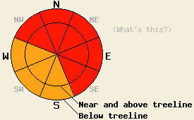
The avalanche danger will rise to HIGH on NW-N-NE-E-SE aspects on slopes steeper than 35 degrees at all elevations today and tonight. On the S-SW-W aspects the avalanche danger will reach CONSIDERABLE on slopes steeper than 35 degrees. Large natural and human-triggered avalanche will become likely due to to strong winds and intense snowfall during the next 24 hours. |
|
|
|
The first storm in this series added another 7-13 inches of new snow during the last 24 hours bringing storm totals to 12-18 inches so far. The second storm in this series has already started to move into the area causing the southwest winds to increase. These winds may shift a little more to the south today before moving back to the southwest tonight. The wind should continue to increase today with gusts over 110 mph along the ridge-lines and up to 100 mph between 7000 ft and 8000 ft this afternoon. The forecast calls for sustained winds in the 50-70 mph above 8000 ft and 30-35 mph at lower elevations. This storm could bring another 2-3 ft of snow to the mountains above 7000 ft by tomorrow morning. Periods of high intensity snowfall should occur in the next 24 hours especially this afternoon and evening when snowfall rates could reach 2-3 inches per hour. By tomorrow this storm should continue eastward. Snowfall and winds should decrease before the arrival of the last storm in this series on Saturday.
Yesterday on Lincoln Ridge near Yuba Pass, ski cuts and kicks on steep, wind-loaded test slopes in both above and below treeline terrain caused small 1-2 ft deep avalanches that would run the length of the test slope. These slides failed about 2 inches below the base of the yesterday's new storm snow on the boundary between a soft light layer of snow and a more dense layer of snow. On less steep wind-affected, slopes skier triggered shooting cracks occurred. Below treeline these cracks only ran for 1-3 ft from the end of the skis. Above treeline they shot out 3-4 ft. On steep non-wind-affected test slopes, skier triggered sluffs that entrained the top 2-4 inches of new snow occurred (photos, video, more info). Farther south on Angora Peak, a backcountry skier reported some minor cracks on undercut wind-affected slopes near treeline. His pit data also showed a layer of light snow underneath a layer of heavier snow. Stability tests showed that the lighter layer remained too weak to support the heavier layer in that area (pit profile).
Avalanche Concern #1: Wind Slabs
Large natural and human-triggered avalanches will become likely on wind-loaded slopes today. Strong winds at all elevations and new snow will create new wind slabs on top of older unstable wind slabs and on top of lighter softer snow. These new wind slabs will add enough weight to the snowpack to break the weak bonds holding them in place. The widespread strong winds will deposit wind slabs on any wind-exposed slopes above or below treeline and could affect the snow in areas that are more traditionally sheltered as well. The leeward NW-N-NE-E-SE aspects will hold the largest and most fragile slabs. As the snow accumulates, triggering these wind slabs will become easier and easier today. Large, deep, and destructive avalanches that step down below the today's storm snow could result from the failure of these wind slabs.
Avalanche Concern #2: Storm Snow Weaknesses
The new snow that falls today will likely accumulate faster than bonds that could hold it in place can form. Changing temperatures and winds during the storm will also create other weaknesses within the new snow. As the new snow accumulates, natural and human-triggered soft slab avalanches and loose snow sluffs will be likely. These will remain smaller than the wind slabs but could still reach a few feet in depth. They could easily bury a person or push him/her into an area that has serious consequences like a stand of trees, over a cliff, into a gully or treewell, or into some other terrain trap. These kind of slides could occur on any steep, open slopes that receive significant new snow today.
The avalanche danger will rise to HIGH on NW-N-NE-E-SE aspects on slopes steeper than 35 degrees at all elevations today and tonight. On the S-SW-W aspects the avalanche danger will reach CONSIDERABLE on slopes steeper than 35 degrees. Large natural and human-triggered avalanche will become likely due to to strong winds and intense snowfall during the next 24 hours.
| 0600 temperature: | 14-18 deg. F. |
| Max. temperature in the last 24 hours: | 22-27 deg. F. |
| Average wind direction during the last 24 hours: | Southwest |
| Average wind speed during the last 24 hours: | 45 mph |
| Maximum wind gust in the last 24 hours: | 97 mph |
| New snowfall in the last 24 hours: | 7-13 inches |
| Total snow depth: | 127-193 inches |
For 7000-8000 ft: |
|||
| Thursday: | Thursday Night: | Friday: | |
| Weather: | Snow | Snow | Snow likely in the morning becoming showers in the afternoon |
| Temperatures: | 24-30 deg. F. | 13-20 deg. F. | 25-31 deg. F. |
| Wind direction: | Southwest shifting more to the south in the afternoon | Southwest | Southwest |
| Wind speed: | 25-35 mph with gusts to 70 mph increasing to 100 mph in the afternoon | 20-30 mph with gusts to 85 mph decreasing to 60 mph after midnight | 15-25 mph with gusts to 40 mph |
| Expected snowfall: | 7-14 in. | 9-16 in. | 2-6 in. |
For 8000-9000 ft: |
|||
| Thursday: | Thursday Night: | Friday: | |
| Weather: | Snow | Snow | Snow likely in the morning becoming showers in the afternoon |
| Temperatures: | 19-25 deg. F. | 13-19 deg. F. | 20-26 deg. F. |
| Wind direction: | Southwest shifting more to the south in the afternoon | Southwest | Southwest |
| Wind speed: | 45-60 mph with gusts to 95 mph increasing to 55-70 mph with gusts to 110 mph in the afternoon | 45-65 mph with gusts to 115 mph decreasing to 30-45 mph with gusts to 75 mph after midnight | 20-30 mph with gusts to 60 mph decreasing to 50 mph in the afternoon |
| Expected snowfall: | 9-16 in. | 12-20 in. | 4-8 in. |


This website is owned and maintained by the non-profit arm of the Sierra Avalanche Center. Some of the content is updated by the USDA avalanche forecasters including the forecasts and some observational data. The USDA is not responsible for any advertising, fund-raising events/information, or sponsorship information, or other content not related to the forecasts and the data pertaining to the forecasts.

