In partnership with: 
|
April 1, 2011 at 6:30 am |
|
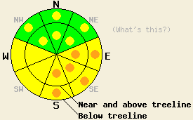
On E-SE-S aspects avalanche danger is MODERATE with pockets of CONSIDERABLE danger forming today at all elevations on slopes 35 degrees and steeper. On SW-W aspects avalanche danger is MODERATE at all elevations on slopes 35 degrees and steeper. On NW-N-NE aspects, avalanche danger is LOW with pockets of MODERATE danger forming at all elevations on slopes 35 degrees and steeper. |
|
|
|
Another very warm day is in store for the region before increasing cloud cover and light precipitation move into the forecast area tonight and tomorrow. An air temperature inversion is in place once again this morning with near to slightly below freezing air temperature on the mountain valley floors. The vast majority of remote sensors above 8,000' are reporting overnight lows in the mid to upper 40s this morning. Ridgetop winds were calm yesterday and are just beginning to increase out of the southwest. Light to moderate speed southwest ridgetop winds are expected by mid morning. Air temperatures above 7,000' are forecast to climb into the mid 50s to low 60s today.
Observations made yesterday on Mt. Tallac (Desolation Wilderness area) revealed widespread wet snow in nearly all areas by mid day. At 10am, wet snow up to 6 inches deep existed on all aspects below 7,000'. Above 8,000' significant wet snow was limited to solar aspects with up to 4 inches of wet snow on the surface with cold recent storm snow below. Only 1-2 inches of wet snow existed on the snow surface on northerly aspects above 8,000' at 1pm. Above 9,200', a cold unmelted snow surface remained on true N aspects at 1pm. Runnels existed in most areas below 8,000' on E-SE-S aspects indicating good drainage of free water out of the recent storm snow. In isolated areas runnels existed at higher elevations and were noted to extend all the way to the top of the E aspect Corkscrew avalanche path at 9,100'. Runnels existed only up to about 8,000'-8,200' in the upper Tallac Creek bowl which has a more NE to ENE general aspect. Naturally triggered roller ball activity over 1 foot in diameter was witnessed at 12:45 pm in upper Tallac Creek bowl on the ESE aspect N edge of the bowl around 9,000' to 9,200'. No recent roller ball activity was observed in areas where runnels existed (photos, more info).
Avalanche Concern #1: Warming Instability
A second night in a row has passed with very little to no snow surface refreeze expected in areas above 7,000'. With very warm air temperatures expected for today, areas of wet snow instability are expected to form by mid morning. Isolated areas of naturally triggered wet loose snow avalanches are possible today. The greatest areas of instability are expected to form on E-SE-S aspects at the mid and upper elevations in areas where drainage out of the upper snowpack is not well established. The absence of a significant weak layer within the melting upper portion of the snowpack is expected to keep wet slab avalanche activity unlikely to very isolated today. Glide cracks are expected to continue to open up in areas where a comparatively shallow snowpack exists over smooth rock slabs in areas that receive significant sun exposure. Areas of wet snow instabilities are expected to spread to northerly aspects today as well, mainly at the mid and lower elevations.
Avalanche Concern #2: Large Cornice Failure
Sudden collapse of large to very large sections of cornice remains possible today and will continue to present a significant hazard to backcountry travelers. The likelihood that cornice collapse will trigger a slab avalanche on the impacted slope below is becoming increasingly unlikely. However, the large multiple ton pieces of cornice debris falling and sliding down the slope below are sufficient to cause serious injury. Stay well back from the edges of cornices, preferably to the areas where exposed rocks are visible sticking up out of the snow surface. Reports of cornice failure up to 30' back from the edge have been received over the past few days. Avoid stopping or gathering with other backcountry travelers on slopes directly below large cornice features.
On E-SE-S aspects avalanche danger is MODERATE with pockets of CONSIDERABLE danger forming today at all elevations on slopes 35 degrees and steeper. On SW-W aspects avalanche danger is MODERATE at all elevations on slopes 35 degrees and steeper. On NW-N-NE aspects, avalanche danger is LOW with pockets of MODERATE danger forming at all elevations on slopes 35 degrees and steeper.
| 0600 temperature: | 43 to 48 deg. F. |
| Max. temperature in the last 24 hours: | 59 to 62 deg. F. |
| Average wind direction during the last 24 hours: | Southwest |
| Average wind speed during the last 24 hours: | 7 mph |
| Maximum wind gust in the last 24 hours: | 23 mph |
| New snowfall in the last 24 hours: | O inches |
| Total snow depth: | 114 to 181 inches |
For 7000-8000 ft: |
|||
| Friday: | Friday Night: | Saturday: | |
| Weather: | Sunny skies in the morning with increasing high clouds in the afternoon. | Mostly cloudy skies with a slight chance of rain or snow showers after midnight. | Cloudy skies with a slight chance of rain showers in the morning. Mostly cloudy skies with rain and snow showers likely in the afternoon. |
| Temperatures: | 59 to 64 deg. F. | 34 to 39 deg. F. | 43 to 48 deg. F. |
| Wind direction: | SW | SW | SW |
| Wind speed: | 10 to 20 mph with gusts to 30 mph in the afternoon. | 15 to 25 mph with gusts to 45 mph. | 20 to 30 mph with gusts 45 to 60 mph. |
| Expected snowfall: | O in. | 0 to trace in. | 0 to trace in. |
For 8000-9000 ft: |
|||
| Friday: | Friday Night: | Saturday: | |
| Weather: | Sunny skies in the morning with increasing high clouds in the afternoon. | Mostly cloudy skies with a slight chance of rain or snow showers after midnight. | Cloudy skies with a slight chance of rain or snow showers in the morning. Mostly cloudy skies with snow showers likely in the afternoon. |
| Temperatures: | 54 to 62 deg. F. | 31 to 36 deg. F. | 36 to 43 deg. F. |
| Wind direction: | SW | SW | SW |
| Wind speed: | 10 to 20 mph with gusts to 40 mph. | 20 to 35 mph with gusts to 55 mph. | 30 to 45 mph with gusts to 70 mph. |
| Expected snowfall: | O in. | 0 to trace in. | Up to 1 in. |


This website is owned and maintained by the non-profit arm of the Sierra Avalanche Center. Some of the content is updated by the USDA avalanche forecasters including the forecasts and some observational data. The USDA is not responsible for any advertising, fund-raising events/information, or sponsorship information, or other content not related to the forecasts and the data pertaining to the forecasts.

