In partnership with: 
|
April 9, 2011 at 6:34 am |
|
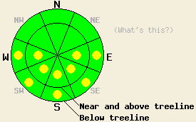
Early this morning, avalanche danger is LOW for all elevations and aspects. Isolated pockets of MODERATE danger are expected to form on open sun exposed E-SE-S-SW-W aspects on slopes 37 degrees and steeper in response to daytime warming. |
|
|
|
A mix of partly cloudy to mostly cloudy skies with plenty of sun breaks interspersed with isolated snow showers are expected today across the forecast area. Off and on snow showers over the past 24 hours added an additional trace to 2 inches of new snow to the region. Air temperatures this morning above 7,000' are in the low to mid teens with around 10 to 15 degrees of daytime warming expected. Ridgetop winds remain out of the NE this morning. Wind speeds were light during the day yesterday and did not increase to moderate in speed until around 11 pm last night. Wind speed has gradually decreased early this morning. Wind direction is forecast to shift to the NW to W today with speeds remaining light to moderate. Mostly cloudy skies with above freezing air temperatures at nearly all elevations are expected for tomorrow.
Observations made yesterday in the Fireplug area of Tamarack Peak (Mount Rose area) revealed no evidence of slab instability in near treeline and below treeline terrain on N-NE-E-SE-S aspects between 8,300' and 9,200'. On northerly aspects near treeline, a wind slab of 4 finger to 1 finger hard snow sat on top of a knife hard melt freeze crust bed surface, but no weak layer existed between the slab and the bed surface. Excellent bonding of recent storm snow to the old snow melt freeze crust surface prevented any slab instability in this area. No evidence of near crust faceting that would weaken this good bonding has been observed. The good to excellent bonding at the old/new snow interface was noted on all aspects traveled (pit profile, photo, more info). At 1 pm some skier triggered roller balls occurred on an open sun exposed E aspect at 9,000' but did not exceed 1 foot in diameter before breaking apart.
Primary Avalanche Concern: Warming Instability
Isolated areas of warming instability may occur today driven mainly by solar radiation. Even though air temperatures will remain below freezing in most areas above 7,500', April levels of incoming solar radiation will act quickly during breaks in cloud cover to warm the snow surface. Most wet snow instability today is expected to take the form of human triggered roller balls, but human triggered wet loose snow avalanches are possible in isolated areas. Open E-SE-S-SW-W aspects with direct sun exposure will hold the greatest potential for warming instability today.
Secondary Avalanche Concern: Wind Slabs
Last night NE winds finally met forecast winds speeds and were strong enough to move snow. Plenty of snow was available for wind transport, but only very small wind slabs are expected to have formed in lee areas near and above treeline. The size of these slabs are not expected to present a significant hazard to backcountry travelers. Human triggered slab avalanches of any significant size involving these newly formed wind slabs are unlikely today. Some cracking is expected, especially in sun exposed areas, but any instability beyond that is not expected.
Early this morning, avalanche danger is LOW for all elevations and aspects. Isolated pockets of MODERATE danger are expected to form on open sun exposed E-SE-S-SW-W aspects on slopes 37 degrees and steeper in response to daytime warming.
| 0600 temperature: | 12 to 17 deg. F. |
| Max. temperature in the last 24 hours: | 18 to 26 deg. F. |
| Average wind direction during the last 24 hours: | Northeast |
| Average wind speed during the last 24 hours: | 19 mph |
| Maximum wind gust in the last 24 hours: | 39 mph |
| New snowfall in the last 24 hours: | Trace to 2 inches |
| Total snow depth: | 105 to 173 inches |
For 7000-8000 ft: |
|||
| Saturday: | Saturday Night: | Sunday: | |
| Weather: | Partly cloudy skies with isolated snow flurries in the morning. | Mostly cloudy skies with isolated snow showers in the evening. | Mostly cloudy skies. |
| Temperatures: | 26 to 33 deg. F. | 16 to 23 deg. F. | 38 to 44 deg. F. |
| Wind direction: | NE shifting to NW | W shifting to SW | SW |
| Wind speed: | Up to 10 mph. | 10 to 15 mph. | 10 to 15 mph. |
| Expected snowfall: | 0 to trace in. | 0 to trace in. | O in. |
For 8000-9000 ft: |
|||
| Saturday: | Saturday Night: | Sunday: | |
| Weather: | Partly cloudy skies in the morning, becoming mostly cloudy. Isolated snow showers. | Mostly cloudy skies with isolated snow showers in the evening. | Mostly cloudy skies. |
| Temperatures: | 24 to 30 deg. F. | 14 to 21 deg. F. | 32 to 38 deg. F. |
| Wind direction: | NE shifting to NW | W | SW |
| Wind speed: | 10 to 15 mph with gusts to 30 mph in the afternoon. | 15 to 20 mph with gusts to 35 mph. | 10 to 20 mph with gusts to 35 mph. |
| Expected snowfall: | 0 to trace in. | 0 to trace in. | O in. |


This website is owned and maintained by the non-profit arm of the Sierra Avalanche Center. Some of the content is updated by the USDA avalanche forecasters including the forecasts and some observational data. The USDA is not responsible for any advertising, fund-raising events/information, or sponsorship information, or other content not related to the forecasts and the data pertaining to the forecasts.

