In partnership with: 
|
April 15, 2011 at 6:59 am |
|
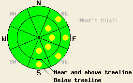
Early this morning, avalanche danger is LOW for all elevations and aspects. Isolated areas of MODERATE danger may form today both above and below treeline on NE-E-SE-S aspects on slopes 35 degrees and steeper in response to daytime warming, especially in the southern portion of the forecast area. |
|
|
|
Weather systems passing to the north of the forecast area will bring periods of cloud cover along with rain and snow showers to the region for the next few days. The best chances of precipitation today are near and north of I-80. Fewer clouds and greater warming is expected in the southern portion of the forecast area today. Increased cloud cover last night helped to keep air temperatures above freezing in nearly all locations below 8,000'. Ridgetop winds are moderate in speed out of the southwest this morning. Moderate to strong southwest winds are forecast to continue through tonight. Another day of clouds, light precipitation, and above freezing air temperatures are expected for tomorrow.
Observations made yesterday during the late morning hours on Jake's Peak (West Shore Tahoe area) revealed very little evidence of warming instability had formed by noon. General snow surface conditions consisted of up to 4 inches of new snow above 8,000' in shaded areas on northerly aspects. A few feet away in sun exposed areas, this snow had settled and slightly melted down to less than 1 inch. The new snow was well bonded to the old snow surface in all areas with no evidence of slab instability. Any areas with significant depth of wind loaded or wind drifted new snow were small, patchy, and nonreactive to the weight of a skier. Below 8,000' where air temperatures were warmer, too little new snow existed to present much of a warming instability issue. Above 8,000' where more snow existed, very little warming was occurring. Skier trigger roller balls that occurred at noon on an E aspect at 8,340' remained very small due to minimal free water formation within the new snow layer at that time (video, more info).
Observations made yesterday afternoon in the Carson Pass area revealed that cloud cover and winds prevented snow surface melting until the mid afternoon hours when a decrease in cloud cover and wind speed occurred. Moderate sized natural wet snow point releases loose snow avalanches were observed on Deadwood Peak (S of Round Top) near 8,800' below the E aspect mid-slope cliffs. No warming instabilities were observed in the Round Top area proper. Evidence of similar small to moderate sized point release wet loose snow avalanches were observed from Meyers later in the afternoon on generally NE to E aspects of Echo and Flagpole peaks. Windward SW-W aspects were mostly stripped down to a crust, which began to warm by mid-afternoon, becoming breakable with the occasional thin melt layer where sheltered from the wind. Leeward N-NE aspects had variable new snow deposition averaging 4 to 6 inches deep with small pockets 8 to 12 inches deep that covered areas up to approximately 80' by 80'. No evidence of slab instability was observed in these areas. Limited warming on northerly aspects was promoting settlement of the new snow and bonding to the crust layer below (more info).
Primary Avalanche Concern: Warming Instability
The cloud cover and warm air temperatures last night are expected to have allowed for a refreeze of only the top few inches of the snow surface last night. Sun breaks this morning followed by increasing afternoon cloud cover and moderate to strong winds will greatly slow snow surface melting in the northern portion of the forecast area today. Ongoing sun breaks through the afternoon hours will allow for more solar radiation to reach the snow surface in the southern portion of the forecast area. The amount of wet snow instability that forms today is expected to increase from north to south within the forecast area. Areas where recent new snow has not melted and assimilated with the older melt freeze crust below it will hold the greatest potential for small to medium sized wet loose snow avalanches today. This will mainly occur on NE-E aspects above 8,000'. SE-S aspects at all elevations will see more typical melt freeze conditions today. Areas with greater protection from SW winds will experience greater amounts of snow surface warming today. Convective cooling by moderate to strong SW winds are expected to keep snow surface melting to a minimum today on SW-W aspects.
Early this morning, avalanche danger is LOW for all elevations and aspects. Isolated areas of MODERATE danger may form today both above and below treeline on NE-E-SE-S aspects on slopes 35 degrees and steeper in response to daytime warming, especially in the southern portion of the forecast area.
| 0600 temperature: | 28 to 34 deg. F. |
| Max. temperature in the last 24 hours: | 31 to 41 deg. F. |
| Average wind direction during the last 24 hours: | West southwest |
| Average wind speed during the last 24 hours: | 25 mph |
| Maximum wind gust in the last 24 hours: | 43 mph |
| New snowfall in the last 24 hours: | O inches |
| Total snow depth: | 98 to 163 inches |
For 7000-8000 ft: |
|||
| Friday: | Friday Night: | Saturday: | |
| Weather: | Mostly cloudy to cloudy skies with isolated showers. | Mostly cloudy skies with a slight chance of showers. | Mostly cloudy skies with a slight chance of showers. |
| Temperatures: | 43 to 55 deg. F. | 27 to 34 deg. F. | 47 to 55 deg. F. |
| Wind direction: | SW | SW | SW |
| Wind speed: | 15 to 25 mph with gusts to 40 mph. | 10 to 20 mph with gusts to 40 mph. | Around 10 mph in the morning increasing to 15 to 25 mph with gusts to 40 mph in the afternoon. |
| Expected snowfall: | 0 to trace in. | 0 to trace in. | 0 to trace in. |
For 8000-9000 ft: |
|||
| Friday: | Friday Night: | Saturday: | |
| Weather: | Mostly cloudy to cloudy skies with isolated showers. | Mostly cloudy skies with a slight chance of showers. | Mostly cloudy skies with a slight chance of showers. |
| Temperatures: | 38 to 46 deg. F. | 24 to 31 deg. F. | 41 to 49 deg. F. |
| Wind direction: | SW | W | W |
| Wind speed: | 20 to 35 mph with gusts to 60 mph. | 25 to 35 mph with gusts to 65 mph. Gusts decreasing to 55 mph after midnight. | 15 to 25 mph with gusts to 35 mph. Gusts increasing to 45 mph in the afternoon. |
| Expected snowfall: | 0 to trace in. | 0 to trace in. | 0 to trace in. |


This website is owned and maintained by the non-profit arm of the Sierra Avalanche Center. Some of the content is updated by the USDA avalanche forecasters including the forecasts and some observational data. The USDA is not responsible for any advertising, fund-raising events/information, or sponsorship information, or other content not related to the forecasts and the data pertaining to the forecasts.

