In partnership with: 
|
April 16, 2011 at 7:00 am |
|
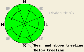
The avalanche danger should remain LOW for all elevations and aspects today. Some minor wet snow instabilities could form due to daytime warming. Larger wet snow instabilities and wet slab avalanches will remain unlikely today but not impossible. |
|
|
|
Scattered showers yesterday produced some light rain in area around the forecast area up to at least 8000 ft. The clouds and showers dissipated in the evening and mostly clear skies persisted through the night. The skies remain mostly clear this morning. The forecast calls for more clouds and a 25% chance of some light showers this afternoon due to another low pressure passing north of the region. With warmer temperatures continuing today snow level should remain close to 8500 ft. A stronger low pressure should begin to approach the forecast area tomorrow causing more clouds and increased southwest winds. Temperatures should remain above normal with the daytime highs today and tomorrow in the mid to upper 40's above 7000 ft.
Yesterday on Schallenberger Ridge above Donner Lake, most of the recent snow had made the transition to melt-freeze snow below 7200 ft. In some areas on the northerly aspects, some of the recent snow still had not quite gone through enough melt-freeze cycles to complete the change. In these areas some some small skier triggered roller balls did occur (photo and more info). In areas on these more north and east aspects where the recent snow had finished making this transition, one inch of soft melt-freeze snow existed on the snow surface by 1:30 pm. On the southerly aspects one to two inches of soft corn snow had formed on by 1pm. On all aspects a thick, strong, and frozen melt-freeze crust existed below the soft surface snow.
Primary Avalanche Concern: Warming Instabilities
Clear skies overnight and temperatures close to freezing in most areas will have allowed the snowpack to undergo a decent overnight refreeze. As the sun hits the snow surface today and temperatures climb, some melting should start to occur in the snowpack. Fortunately the snowpack has seen enough melt-freeze cycles for drainage channels to form in it. These drainage channels will allow the water formed during today's melting to flow through the snowpack rather than to collect in one specific layer and saturate that layer. As the winds and clouds increase this afternoon, melting should slow down. Wet snow instabilities that form today should remain limited to small roller balls and some small wet sluffs. Larger wet snow instabilities and wet slab avalanches will remain unlikely today but not impossible.
The avalanche danger should remain LOW for all elevations and aspects today. Some minor wet snow instabilities could form due to daytime warming. Larger wet snow instabilities and wet slab avalanches will remain unlikely today but not impossible.
| 0600 temperature: | 31-36 deg. F. |
| Max. temperature in the last 24 hours: | 37-44 deg. F. |
| Average wind direction during the last 24 hours: | West |
| Average wind speed during the last 24 hours: | 20 mph |
| Maximum wind gust in the last 24 hours: | 42 mph |
| New snowfall in the last 24 hours: | Above 8000 ft. less than .5 inches |
| Total snow depth: | 97-160 inches |
For 7000-8000 ft: |
|||
| Saturday: | Saturday Night: | Sunday: | |
| Weather: | Sunny this morning then becoming mostly cloudy with isolated showers | Mostly cloudy in the evening then becoming partly cloudy | Mostly cloudy with a slight chance of showers |
| Temperatures: | 48-53 deg. F. | 30-35 deg. F. | 46-52 deg. F. |
| Wind direction: | West shifting to the Southwest | Southwest | Southwest |
| Wind speed: | 10 mph increasing to 15-20 mph with gusts to 40 mph in the afternoon | 10-15 mph with gusts to 35 mph | 10-15 mph with gusts to 25 mph increasing to 15-25 mph with gusts to 45 mph in the afternoon |
| Expected snowfall: | O in. | O in. | O in. |
For 8000-9000 ft: |
|||
| Saturday: | Saturday Night: | Sunday: | |
| Weather: | Sunny this morning then becoming mostly cloudy with isolated showers | Mostly cloudy in the evening then becoming partly cloudy | Mostly cloudy with a slight chance of showers |
| Temperatures: | 43-47 deg. F. | 26-32 deg. F. | 40-46 deg. F. |
| Wind direction: | West shifting to the Southwest | Southwest | Southwest |
| Wind speed: | 10-15 mph with gusts to 25 mph increasing to 15-25 mph with gusts to 45 mph in the afternoon | 10-20 mph with gusts to 35 mph | 25-35 mph with gusts to 55 mph |
| Expected snowfall: | O in. | O in. | O in. |


This website is owned and maintained by the non-profit arm of the Sierra Avalanche Center. Some of the content is updated by the USDA avalanche forecasters including the forecasts and some observational data. The USDA is not responsible for any advertising, fund-raising events/information, or sponsorship information, or other content not related to the forecasts and the data pertaining to the forecasts.

