In partnership with: 
|
April 21, 2011 at 6:42 am |
|
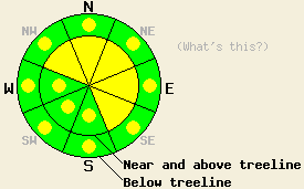
Near and above treeline, avalanche danger is MODERATE above 7,500' on NW-N-NE-E-SE aspects on slopes 35 degrees and steeper. For all other areas, pockets of MODERATE danger exist on all aspects at all elevations on slopes 35 degrees and steeper. |
|
|
|
Rain and snow fell across the forecast area last night. Snow level fluctuated between 6,000' and 7,000'. New snow amounts of 2 to 7 inches have accumulated overnight above 7,500'. Light snowfall continues this morning with snow level around 6,000'. An additional 1 to 2 inches of new snow is expected to accumulate this morning with precipitation tapering off by this evening. Ridgetop winds remain moderate to strong in speed out of the southwest and are forecast to decrease to moderate in speed this afternoon. Air temperatures below 9,000' are expected to warm into the low 30s to low 40s today, but atmospheric conditions should keep precipitation mostly as snow across the region. For tomorrow expect mostly cloudy skies, light winds, above freezing air temperatures, and a slight chance of snow showers in the afternoon.
Observations made yesterday on Silver Peak (Pole Creek area) noted supportable melt freeze crust conditions existed at 1pm on northerly aspects above 7,700' and on all aspects above 7,900'. On open sun exposed E-SE-S aspects below 7,600' the snowpack was unsupportable to the weight of a skier with widespread small to medium size skier triggered roller balls active on slopes steeper than 35 degrees. Deep wet snow (3+ feet) existed in all areas below 7,000', but remained supportable in low angle terrain (pit profile, more info).
Primary Avalanche Concern: Storm Snow Instability
New snow overnight is expected to have formed areas of storm snow instability above 7,500'. The warm wet nature of this storm is expected to have allowed for good bonding of new snow to the melt freeze crust at the old snow surface. Expected instabilities today are focused on weaknesses within the storm snow and on slabs formed by wind loading. The areas of greatest storm snow instability are expected near and above treeline on NW-N-NE-E-SE aspects above 7,500' that have received wind loading. Natural avalanches may have occurred overnight in isolated areas, but are unlikely today due to decreasing snowfall intensity and minimal snow available for continued wind loading. Human triggered avalanches are possible throughout the day today.
Secondary Avalanche Concern: Wet Snow Instability
Significant wet snow was observed yesterday in areas below 7,600'. Much of this terrain received 0.5 to 0.8 inches of rain last night, adding additional free water to the already wet snow. Air temperatures have dropped below freezing down to 6,500' this morning and some amount of snow surface refreeze is occurring. Warm air temperatures today may allow for melting of surface snow. The amount that occurs will be limited by the cooling effects of light snowfall and moderate to strong SW winds. Most of the wet snow instability today is expected below 7,500, but may occur at higher elevations as well. Wet snow instability today is expected mainly in the form of human triggered wet loose snow sluffs in steep terrain. Natural and human triggered wet slab avalanches are unlikely but not impossible in isolated areas such as on top of smooth rock slabs and near glide cracks.
Near and above treeline, avalanche danger is MODERATE above 7,500' on NW-N-NE-E-SE aspects on slopes 35 degrees and steeper. For all other areas, pockets of MODERATE danger exist on all aspects at all elevations on slopes 35 degrees and steeper.
| 0600 temperature: | 26 to 29 deg. F. |
| Max. temperature in the last 24 hours: | 30 to 38 deg. F. |
| Average wind direction during the last 24 hours: | Southwest |
| Average wind speed during the last 24 hours: | 54 mph |
| Maximum wind gust in the last 24 hours: | 97 mph |
| New snowfall in the last 24 hours: | 2 to 7 inches |
| Total snow depth: | 92 to 161 inches |
For 7000-8000 ft: |
|||
| Thursday: | Thursday Night: | Friday: | |
| Weather: | Cloudy skies with numerous snow showers in the morning. Mostly cloudy skies with scattered snow showers in the afternoon. | Mostly cloudy skies. | Mostly cloudy skies with a slight chance of snow showers in the afternoon. |
| Temperatures: | 37 to 43 deg. F. | 16 to 23 deg. F. | 41 to 47 deg. F. |
| Wind direction: | SW | W shifting to E after midnight. | E |
| Wind speed: | 20 to 35 mph with gusts to 65 mph. Gusts decreasing to 55 mph in the afternoon. | 10 to 15 mph with gusts to 30 mph. | Around 10 mph. |
| Expected snowfall: | 1 in. | O in. | 0 to trace in. |
For 8000-9000 ft: |
|||
| Thursday: | Thursday Night: | Friday: | |
| Weather: | Cloudy skies with numerous snow showers in the morning. Mostly cloudy skies with scattered snow showers in the afternoon. | Mostly cloudy skies. | Mostly cloudy skies with a slight chance of snow showers in the afternoon. |
| Temperatures: | 32 to 38 deg. F. | 13 to 20 deg. F. | 34 to 42 deg. F. |
| Wind direction: | SW | W shifting to E after midnight. | SE |
| Wind speed: | 40 to 55 mph with gusts to 80 mph. Winds decreasing to 20 to 30 mph with gusts to 45 mph in the afternoon. | 15 to 25 mph with gusts to 35 mph, shifting and decreasing to 10 to 15 mph. | 10 to 15 mph with gusts to 25 mph in the afternoon. |
| Expected snowfall: | 1 to 2 in. | O in. | 0 to trace in. |


This website is owned and maintained by the non-profit arm of the Sierra Avalanche Center. Some of the content is updated by the USDA avalanche forecasters including the forecasts and some observational data. The USDA is not responsible for any advertising, fund-raising events/information, or sponsorship information, or other content not related to the forecasts and the data pertaining to the forecasts.

