In partnership with: 
|
April 23, 2011 at 6:36 am |
|
Today the avalanche danger should remain LOW for all elevations and aspects due to light winds, little new snow accumulation, increased cloud cover, and cooler temperatures. Large, dangerous avalanche activity will remain unlikely but not impossible. This will be the last advisory of the 2010-2011 winter. The observations pages will remain active so please continue to share your backcountry observations here: snowpack obs, avalanche obs. Thanks to everyone who makes the avalanche center possible. |
|
|
|
The first of a series of small disturbances passed through the forecast area over the last 24 hours. It left two to three inches of new snow in the mountains above 7000 ft. The southwest winds accompanying this storm averaged 20-25 mph over the Crest during the day yesterday before becoming light overnight. The unsettled weather should continue with a few more weak systems impacting the forecast area this afternoon and tonight. Similar to this first system snow accumulations should remain light. As today's system approaches clouds and southwest winds should increase. Show showers that produce little accumulation should continue through Monday. By Monday the winds could increase significantly as the jet stream shifts closer to the region.
Observations made yesterday morning on Jake's Peak (West Shore Tahoe area) revealed supportable crust conditions existed below 7,800' on all aspects at 10am. Above 8,000', the recent new snow of up to 4 inches was not assimilated with the melt freeze layer below. On N-NE aspects the recent new snow was either unmelted or capped by a 1 inch thick melt freeze crust. On E-SE aspects the new snow was very wet and melting but still not fully assimilated. Refreeze last night likely finished the assimilation process. Descending open NE-E-SE aspects between 8,400' and 8,000' small skier triggered roller balls occurred, but the wet recent new snow was too well bonded to the crust below to create any wet loose snow sluffs (photo, more info).
Avalanche Concerns:
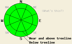
Avalanche concerns for today are few. Recent new snow from Wednesday night is either well bonded to the old snow surface on NW-N-NE aspects, or it has melted and assimilated with the older melt freeze layer below 8000 ft on E-SE-S-SW-W aspects. No significant weak layers have been observed either within this recent new snow layer or at the old/new snow interface in pockets of terrain where unmelted recent new snow exists. Light winds and the two to three inches of new snow that accumulated in the last 24 hours may have created some small human-trigger-able slabs. However, these are not expected to have grown large enough to present a significant hazard to backcountry travelers. Daytime warming will cause some snow surface melting today and may create some small roller balls or small sluffs. The melting that occurs today is not expected to cause significant areas wet snow instability due to cooler temperatures and increased cloud cover. Natural or human triggered wet snow avalanches are unlikely but not impossible in isolated areas, especially on top of smooth rock slabs and near glide cracks.
Today the avalanche danger should remain LOW for all elevations and aspects due to light winds, little new snow accumulation, increased cloud cover, and cooler temperatures. Large, dangerous avalanche activity will remain unlikely but not impossible. This will be the last advisory of the 2010-2011 winter. The observations pages will remain active so please continue to share your backcountry observations here: snowpack obs, avalanche obs. Thanks to everyone who makes the avalanche center possible.
| 0600 temperature: | 22-27 deg. F. |
| Max. temperature in the last 24 hours: | 31-37 deg. F. |
| Average wind direction during the last 24 hours: | Southwest |
| Average wind speed during the last 24 hours: | 15 mph |
| Maximum wind gust in the last 24 hours: | 39 mph |
| New snowfall in the last 24 hours: | 2-3 inches |
| Total snow depth: | 95-160 inches |
For 7000-8000 ft: |
|||
| Saturday: | Saturday Night: | Sunday: | |
| Weather: | Mostly cloudy in the morning then becoming cloudy. Scattered snow showers. | Mostly cloudy with scattered snow showers | Mostly cloudy with a chance of snow showers |
| Temperatures: | 36-46 deg. F. | 21-30 deg. F. | 37-47 deg. F. |
| Wind direction: | Southwest | Southwest | Southwest |
| Wind speed: | Light in the morning increasing to 10-15 mph with gusts to 30 mph in the afternoon | 10-15 mph with gusts to 30 mph | 10-15 mph in the morning increasing to 15-25 mph with gusts to 40 mph in the afternoon |
| Expected snowfall: | up to 1 in. | up to 1 in. | trace in. |
For 8000-9000 ft: |
|||
| Saturday: | Saturday Night: | Sunday: | |
| Weather: | Mostly cloudy in the morning then becoming cloudy. Scattered snow showers. | Mostly cloudy with scattered snow showers | Mostly cloudy with a chance of snow showers |
| Temperatures: | 30-40 deg. F. | 18-28 deg. F. | 34-44 deg. F. |
| Wind direction: | Southwest | Southwest | Southwest |
| Wind speed: | Light in the morning increasing to 15-25 mph with gusts to 40 mph in the afternoon | 20-30 mph with gusts to 45 mph | 20-35 mph with gusts to 50 mph increasing to 65 mph in the afternoon |
| Expected snowfall: | up to 2 in. | up to 1 in. | trace in. |


This website is owned and maintained by the non-profit arm of the Sierra Avalanche Center. Some of the content is updated by the USDA avalanche forecasters including the forecasts and some observational data. The USDA is not responsible for any advertising, fund-raising events/information, or sponsorship information, or other content not related to the forecasts and the data pertaining to the forecasts.

