In partnership with: 
|
November 20, 2011 at 8:00 am |
|
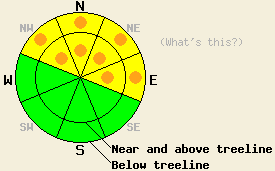
On NW-N-NE-E aspects, avalanche danger is MODERATE with some pockets of CONSIDERABLE both above and below treeline in areas above 8,000' on NW-N-NE-E aspects on slopes 32 degrees and steeper. For all other areas, avalanche danger is LOW. |
|
|
|
After a brief period of calmer weather during the day yesterday, another storm system moved into the area last night bringing increased winds and more new snow. Snowfall from this second storm started after midnight last night and added another 3-5 inches of snow throughout the forecast area. Heavier snowfall should continue this morning with the forecast calling for another 2-5 inches of accumulation today. This additional snow would bring the 2-day snowfall totals up to 11-22 inches. By this afternoon the storm should start to move south with most of the snowfall ending by tonight. A small high pressure ridge should begin to move over the region tomorrow bringing decreased winds, clearing skies, and warmer temperatures.
Yesterday on Castle Peak (Donner Summit area), observations revealed 12 inches of new snow in wind protected areas above 8,000 ft and up to 2 ft of new snow in wind loaded areas. On the NW-N-NE aspects in this area, a layer of older, weak, sugary snow (facets) exists below all of this new snow. These older facets, now known as the Nov. 18th facet layer since they were buried on Nov 18th, barely had enough strength to support yesterday's new snow. Several skier-triggered whumpfs occurred on northerly aspects both below treeline and near treeline as the added weight of a person on top of snowpack caused the older faceted snow to break. Snowpit tests also indicated that fractures can propagate along the top of this faceted layer in a variety of locations between 8,100' and 9,000' on north aspects (more info, videos, snowpits). Recent observations from around the forecast area have noted the presence of this faceted snow layer on northerly aspects above 8,000' prior to becoming buried (more info here).
Avalanche Concern: Persistent slabs
The faceted snow near the ground has now become a persistent weak layer. New snow during the last 48 hours has added the final ingredient in to the avalanche recipe, a slab on top of this persistent weak layer. More snow last night and continued accumulation today will only add more weight to the snowpack and make it even more fragile. In wind-loaded areas larger and deeper slabs will exist on top of the snowpack. On slopes where those facets exist, snowpack failure could occur a few inches above ground level leading to avalanches involving all of the new snow. In areas where snow exists from either last winter or the October 4th-6th storm, an ice layer has formed underneath the facets providing a more efficient bed surface that will allow wider and farther traveling avalanches to occur. Luckily, the persistent weak layer does not exist everywhere. Recent observations indicate that this layer will most likely live on NW-N-NE-E aspects above 8000 ft. On these slopes human-triggered avalanches and some natural avalanches will be possible both above and below treeline today.
Early season conditions exists out there. A cold, shallow, and weak snowpack that more resembles Colorado than California requires extra caution. Also snow coverage still remains patchy. Until more snow falls, snow travel may mean dodging shallowly buried rocks, logs, trees, and other knee-breaking, track-tearing, ski-destroying obstacles.
On NW-N-NE-E aspects, avalanche danger is MODERATE with some pockets of CONSIDERABLE both above and below treeline in areas above 8,000' on NW-N-NE-E aspects on slopes 32 degrees and steeper. For all other areas, avalanche danger is LOW.
| 0600 temperature: | 22 deg. F. |
| Max. temperature in the last 24 hours: | 26-30 deg. F. |
| Average wind direction during the last 24 hours: | Southwest |
| Average wind speed during the last 24 hours: | 20-25 mph |
| Maximum wind gust in the last 24 hours: | 60 mph |
| New snowfall in the last 24 hours: | 3-5 inches |
| Total snow depth: | 11-27 inches |
For 7000-8000 ft: |
|||
| Sunday: | Sunday Night: | Monday: | |
| Weather: | Snow in the morning decreasing to snow showers this afternoon | Mostly cloudy with some isolated snow showers | Partly cloudy |
| Temperatures: | 25-30 deg. F. | 17-22 deg. F. | 30-38 deg. F. |
| Wind direction: | South | South | Southwest |
| Wind speed: | 10-15 mph with gusts to 35 mph decreasing to 10 mph with gusts to 25 mph in the afternoon | up to 10 mph with gusts to 25 mph | 10-15 mph with gusts to 35 mph |
| Expected snowfall: | 1-4 in. | O in. | O in. |
For 8000-9000 ft: |
|||
| Sunday: | Sunday Night: | Monday: | |
| Weather: | Snow in the morning decreasing to snow showers this afternoon | Mostly cloudy with some isolated snow showers | Partly cloudy |
| Temperatures: | 22-30 deg. F. | 12-22 deg. F. | 25-32 deg. F. |
| Wind direction: | South | Southwest | Southwest |
| Wind speed: | 20-35 mph with gusts to 50 mph decreasing to 10-15 mph with gusts to 35 mph | 10-15 mph with gusts to 30 mph | 15-25 mph with gusts to 35 mph |
| Expected snowfall: | 2-5 in. | O in. | O in. |


This website is owned and maintained by the non-profit arm of the Sierra Avalanche Center. Some of the content is updated by the USDA avalanche forecasters including the forecasts and some observational data. The USDA is not responsible for any advertising, fund-raising events/information, or sponsorship information, or other content not related to the forecasts and the data pertaining to the forecasts.

