In partnership with: 
|
November 23, 2011 at 7:35 am |
|
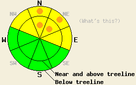
For areas above 8,000 ft, avalanche danger is MODERATE both above and below treeline on NW-N-NE-E aspects on slopes 32 degrees and steeper. Along the Sierra Crest in the northern half of the forecast area, pockets of CONSIDERABLE danger exist above 8,000 ft on N-NE aspects both above and below treeline on slopes 32 degrees and steeper. For all other areas, avalanche danger is LOW. |
|
|
|
Mostly cloudy skies and strong winds are expected today as a splitting trough approaches the forecast area. Remote sensors around 8,500' are showing air temperatures in the upper 30s this morning. Maximum daytime air temperatures in the mid 30s to mid 40s are forecast for areas above 7,000'. Ridgetop winds remain strong out of the southwest and are expected to continue into tomorrow. Minimal new snow accumulation is expected to occur overnight tonight into tomorrow morning.
Observations made yesterday on Silver Peak (Upper Pole Creek area) matched well with previous thinking that the Nov 18 facet layer is stable below 8,000'. A variety of formal and informal observations made both above and below treeline on N-NE aspects between 7,600' and 8,000' revealed no evidence of instability. In this area the Nov 18 facet layer was minimally faceted and well bonded to the recent new snow layer above it (pit profile, more info). Ridgetop winds had heavily affected above treeline areas by scouring windward slopes and wind loading in lee areas. Very minor cracking of hard wind slabs up to 6 inches deep was observed in avalanche start zones on N-NE-E aspects.
Observations made over the past few days from around other portions of the forecast area have revealed significant snowpack instability above 8,000' on N-NE aspects. Areas that hold the deepest snowpack also hold the greatest instability with a thicker, more developed Nov 18 facet layer and a thicker overlying slab. Snowpack collapse with audible whumpfing, shooting cracks, and unstable snowpit test results have been common in these areas (pit profiles, videos, more info).
Avalanche Concern #1: Persistent slabs
Persistent weak instability common in an early season shallow snowpack exists throughout the forecast area. The Nov 18 facet layer ranges from lightly faceted to very faceted and from 2 to 10 inches deep across NW-N-NE-E aspects above 8,000'. Equal instability has been observed both above and below treeline. N-NE aspects have shown the greatest instability. Locations within the forecast area that have been most favored by November snowfall have also shown the greatest amount of instability on this weak layer. Generally the area along the Sierra Crest from Blackwood Canyon north through Donner Summit and Independence Lake holds the most snow available for recreation and subsequently has the greatest snowpack instability. Ongoing whumpfing, shooting cracks, and unstable snowpit test results from the last several days continue to show unstable conditions. Human triggered avalanches are possible to likely on many steep slopes above 8,000' that hold sufficient snow cover for winter recreation endeavors.
Avalanche Concern #2: Wind slabs
Wind transport of snow on the ground over the past two days has created hard wind slab conditions in near and above treeline areas. Most instability associated with wind slab formation was noted over the past two days to occur within the wind slab or at the interface of the wind slab and lower density recent new snow below. In some areas where these slabs have formed, they have added further load to the Nov 18 facet layer. These hard slabs may or may not be able to bridge over the weaker faceted snow below. The amount of snow still available on SW-W aspects for wind transport is minimal. Blowing snow along the ridgetops may not be obvious today. Expect the ongoing possibility of human triggered hard slab avalanches today in recently wind loaded areas near and above treeline on NW-N-NE-E aspects.
For areas above 8,000 ft, avalanche danger is MODERATE both above and below treeline on NW-N-NE-E aspects on slopes 32 degrees and steeper. Along the Sierra Crest in the northern half of the forecast area, pockets of CONSIDERABLE danger exist above 8,000 ft on N-NE aspects both above and below treeline on slopes 32 degrees and steeper. For all other areas, avalanche danger is LOW.
| 0600 temperature: | 32 to 37 deg. F. |
| Max. temperature in the last 24 hours: | 32 to 40 deg. F. |
| Average wind direction during the last 24 hours: | Southwest |
| Average wind speed during the last 24 hours: | 41 mph |
| Maximum wind gust in the last 24 hours: | 75 mph |
| New snowfall in the last 24 hours: | O inches |
| Total snow depth: | 12 to 28 inches |
For 7000-8000 ft: |
|||
| Wednesday: | Wednesday Night: | Thursday: | |
| Weather: | Mostly cloudy skies. | Cloudy skies with a slight chance of snow after midnight. | Cloudy skies with a chance of snow in the morning. A slight chance of snow showers in the afternoon. |
| Temperatures: | 39 to 45 deg. F. | 22 to 29 deg. F. | 32 to 38 deg. F. |
| Wind direction: | SW | SW | SW |
| Wind speed: | 10 to 15 mph increasing to 15 to 30 mph in the afternoon. Gusts to 55 mph. | 15 to 25 mph decreasing to 10 to 15 mph after midnight. Gusts up to 45 mph. | 10 to 20 mph with gusts to 35 mph. Gusts increasing to 45 mph in the afternoon. |
| Expected snowfall: | O in. | 0 to trace in. | Trace in. |
For 8000-9000 ft: |
|||
| Wednesday: | Wednesday Night: | Thursday: | |
| Weather: | Mostly cloudy skies. | Cloudy skies with a slight chance of snow after midnight. | Cloudy skies with a chance of snow in the morning. A slight chance of snow showers in the afternoon. |
| Temperatures: | 34 to 41 deg. F. | 21 to 28 deg. F. | 30 to 33 deg. F. |
| Wind direction: | SW | SW | SW |
| Wind speed: | 30 to 50 mph with gusts to 85 mph. | 30 to 50 mph with gusts to 85 mph. Gusts decreasing to 75 mph after midnight. | 20 to 30 mph with gusts to 50 mph. Gusts increasing to 60 mph in the afternoon. |
| Expected snowfall: | O in. | 0 to trace in. | Trace in. |


This website is owned and maintained by the non-profit arm of the Sierra Avalanche Center. Some of the content is updated by the USDA avalanche forecasters including the forecasts and some observational data. The USDA is not responsible for any advertising, fund-raising events/information, or sponsorship information, or other content not related to the forecasts and the data pertaining to the forecasts.

