In partnership with: 
|
November 29, 2011 at 7:30 am |
|
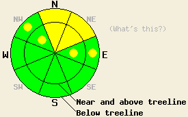
Above 8,000', areas of MODERATE avalanche danger exist both above and below treeline on N-NE aspects on slopes 35 degrees and steeper. Avalanche danger is LOW with pockets of MODERATE danger above 8,000' in both above and below treeline terrain on NW and E aspects on slopes 35 degrees and steeper. For all other areas, avalanche danger is LOW. |
|
|
|
Another day of sunny skies and spring like air temperatures are expected today before a pattern change occurs tomorrow. An air temperature inversion is once again in place over the forecast area. Remote sensors above 8,500' are reporting air temperatures around 40 deg F this morning. Daytime highs for today are forecast to climb into the 40s and 50s at nearly all elevations. Ridgetop winds remain out of the southwest this morning. Wind speed decreased to light yesterday afternoon, but has increasing to moderate in speed this morning. A weather system passing to the east of the forecast area tomorrow is expected to cause a significant cool down. Gale force northeast ridgetop winds are forecast for tomorrow afternoon.
Observations made yesterday on Barker Peak (Blackwood Canyon area) matched well with other recent observations around the forecast area. Snowpit data collected near treeline on a N aspect at 8,060' showed more evidence of ongoing persistent weak instability within the snowpack (pit profile, photos, more info). Skier triggered whumpfing and shooting cracks still occur in areas where the November 18 facet layer remains highly developed (pit profile, photo, more info). In areas where the facets are less developed, snowpit tests continue to show that once fracture is initiated along this weak layer, propagation remains possible. Areas where significant anchoring exist have shown better stability, but the snowpack in these areas is generally too shallow for over snow recreation. Some lingering instability of shallow wind slabs that formed last week have been observed in isolated areas of previous wind loading near and above treeline. A thin and breakable rain crust that formed on Thanksgiving Day exists on the snow surface along the Sierra Crest up to around 9,000' in most areas.
Avalanche Concern #1: Persistent slabs
The November 18 facet layer has shown some gains in strength, but they are slow. This is a persistent weak layer and it will take at least several more weeks for this layer to stabilize in all areas. In locations where the snowpack is deepest, a one to two foot thick slab exists on top of the facet layer. The greatest areas of instability have been observed on N-NE aspects above 8,000', with pockets of instability on NW and E aspects. Heavily shaded, colder slopes with a relatively deeper snowpack and few visible anchors protruding through the snow surface are the most suspect.
Avalanche Concern #2: Wind slabs
Isolated pockets of lingering wind slab are also out there in previously wind loaded areas near and above treeline on NW-N-NE-E aspects. These wind slabs are generally less than one foot thick and difficult to trigger.
Above 8,000', areas of MODERATE avalanche danger exist both above and below treeline on N-NE aspects on slopes 35 degrees and steeper. Avalanche danger is LOW with pockets of MODERATE danger above 8,000' in both above and below treeline terrain on NW and E aspects on slopes 35 degrees and steeper. For all other areas, avalanche danger is LOW.
| 0600 temperature: | 38 to 41 deg. F. |
| Max. temperature in the last 24 hours: | 42 to 48 deg. F. |
| Average wind direction during the last 24 hours: | Southwest |
| Average wind speed during the last 24 hours: | 29 mph |
| Maximum wind gust in the last 24 hours: | 47 mph |
| New snowfall in the last 24 hours: | O inches |
| Total snow depth: | 7 to 23 inches |
For 7000-8000 ft: |
|||
| Tuesday: | Tuesday Night: | Wednesday: | |
| Weather: | Sunny skies. | Partly cloudy skies. | Partly cloudy skies with a slight chance of snow showers in the evening. |
| Temperatures: | 47 to 55 deg. F. | 30 to 36 deg. F. | 34 to 40 deg. F. |
| Wind direction: | SW | W | W shifting to NE in the afternoon. |
| Wind speed: | Around 10 mph. | 10 to 15 mph with gusts to 25 mph after midnight. | 10 to 15 mph shifting and increasing to 15 to 25 mph with gusts to 45 mph. |
| Expected snowfall: | O in. | O in. | 0 to trace in. |
For 8000-9000 ft: |
|||
| Tuesday: | Tuesday Night: | Wednesday: | |
| Weather: | Sunny skies. | Partly cloudy skies. | Partly cloudy skies with a slight chance of snow showers in the evening. |
| Temperatures: | 42 to 52 deg. F. | 26 to 36 deg. F. | 28 to 35 deg. F. |
| Wind direction: | SW | W | W shifting to NE in the afternoon. |
| Wind speed: | 10 to 15 mph with gusts to 30 mph. | 15 to 25 mph with gusts to 35 mph. | 20 to 35 mph with gusts up to 65 mph. |
| Expected snowfall: | O in. | O in. | 0 to trace in. |


This website is owned and maintained by the non-profit arm of the Sierra Avalanche Center. Some of the content is updated by the USDA avalanche forecasters including the forecasts and some observational data. The USDA is not responsible for any advertising, fund-raising events/information, or sponsorship information, or other content not related to the forecasts and the data pertaining to the forecasts.

