In partnership with: 
|
December 2, 2011 at 8:00 am |
|
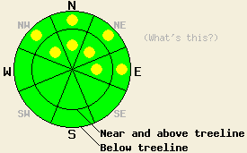
On NW-N-NE-E aspects above 8,000', pockets of MODERATE avalanche danger remain both above and below treeline on slopes 35 degrees and steeper. LOW avalanche danger exists in all other areas. |
|
|
|
The north-northeast winds that have buffeted the region for the last 2 days should continue continue through tomorrow due to another low pressure system passing by the area. The forecast calls for gusts of 70 mph along the Sierra Crest today. As this low moves farther from the forecast area, the winds should start to decrease tomorrow afternoon. Temperatures should warm up some today with daytime highs in the 30's for the mountains above 7000 ft. By tomorrow temperatures should decrease again with daytime highs in the low to mid 20's in the mountains.
On open, wind-exposed N-NE-E facing slopes near and above treeline in the Mt. Rose area yesterday, observers reported significant wind scouring. The strong northeast winds successfully stripped large amounts of unconsolidated faceted snow away from these areas. Across the lake on the Sierra Crest, the rain crust that extends up to 9000 ft. prevented as much scouring from taking place. On Silver Peak above 8000 ft, the Nov 18th facets still exist on the N-NE-E facing aspects (photo). The snow on top of this persistent weak layer has started to weaken changing what was a slab on top of the Nov 18th layer into facets on top of facets. With less strength this overlying snow represents less of a slab. Snowpit tests indicated that the snowpack falls apart before fractures that start in the Nov. 18th facets can travel very far in this area (snowpit). Other observations around the forecast area this week have shown that where the Nov 18th facet layer remains weakest, human triggered shooting cracks, collapses, and whumpfing continue to occur. On slopes where rocks, stumps, logs, and other anchors poke through these facets, this layer represents less of a concern. Of course, recreating on these slopes remains difficult due to those same anchors.
Avalanche Concern #1: Persistent slabs
Cold clear weather and a shallow snowpack should cause the entire snowpack to continue to weaken and facet. This faceting combined with the north-northeast winds scouring snow away from the the northerly aspects will cause the slabs above the Nov 18th facets to decrease in size and extent. This decrease in slab size and distribution will decrease the areas where slab avalanche activity remains possible; however, pockets of terrain still exist with slabs on top of the weak Nov. 18th facets. Unfortunately the terrain most likely to hold these pockets of instability matches the terrain that hold the best recreation potential. The N-NE aspects above 8000 ft. that hold the most snow represent the areas where the thickest and weakest facets exist under the largest slabs. In areas where lots of anchors poke through the snowpack or where the winds have scoured the slab or facets away or where the slab has weakened to the point that it is no longer a slab, fractures in the weak layer should not travel very far.
The Nov, 18th facets will likely still exist as a persistent weak layer in the forecast area for a prolonged period of time. Currently this layer as well as the layers above it continue to weaken. It can take weeks to months for these kinds of weaknesses to stabilize. Layers like this often need to be physically removed by melting, by avalanche activity, or by scouring. The strong NE winds may scour these facets away in some areas but not everywhere. Once new snow returns to the forecast area in significant amounts, these facets could again pose a serious avalanche problem.
On NW-N-NE-E aspects above 8,000', pockets of MODERATE avalanche danger remain both above and below treeline on slopes 35 degrees and steeper. LOW avalanche danger exists in all other areas.
| 0600 temperature: | 18-22 deg. F. |
| Max. temperature in the last 24 hours: | 21-24 deg. F. |
| Average wind direction during the last 24 hours: | North-Northeast |
| Average wind speed during the last 24 hours: | 45 mph |
| Maximum wind gust in the last 24 hours: | 84 mph |
| New snowfall in the last 24 hours: | O inches |
| Total snow depth: | 6-20 inches |
For 7000-8000 ft: |
|||
| Friday: | Friday Night: | Saturday: | |
| Weather: | Partly cloudy this morning becoming sunny this afternoon | Clear | Sunny |
| Temperatures: | 31-38 deg. F. | 13-18 deg. F. | 21-28 deg. F. |
| Wind direction: | Northeast | Northeast | East |
| Wind speed: | 15-30 with gusts to 40 mph | 15-30 mph with gusts to 50 mph | 15-20 mph with gusts to 40 mph |
| Expected snowfall: | O in. | O in. | O in. |
For 8000-9000 ft: |
|||
| Friday: | Friday Night: | Saturday: | |
| Weather: | Partly cloudy this morning becoming sunny this afternoon | Clear | Sunny |
| Temperatures: | 26-32 deg. F. | 11-18 deg. F. | 15-22 deg. F. |
| Wind direction: | Northeast | Northeast | East |
| Wind speed: | 25-45 mph with gusts to 75 mph | 30-45 mph with gusts to 80 mph | 20-30 mph with gusts to 60 mph |
| Expected snowfall: | O in. | O in. | O in. |


This website is owned and maintained by the non-profit arm of the Sierra Avalanche Center. Some of the content is updated by the USDA avalanche forecasters including the forecasts and some observational data. The USDA is not responsible for any advertising, fund-raising events/information, or sponsorship information, or other content not related to the forecasts and the data pertaining to the forecasts.

