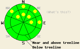
This Avalanche Advisory was published on December 4, 2011:

|
December 4, 2011 at 7:46 am |
|
Very isolated pockets of MODERATE danger may remain above 8,000' on NW-N-NE-E aspects both near treeline and below treeline on slopes 35 degrees and steeper. LOW avalanche danger exists for all other areas. |
|
|
|
Forecast Discussion:
Yet another weather system is passing to the east of the forecast area today. Sunny skies with moderate to strong northeast winds are expected for today. Wind speeds are forecast to increase through this afternoon and overnight before decreasing on Monday. An air temperature inversion is in place over the region with the warmest air above 7,000'. Remote sensors along the Sierra Crest around 8,500' are reporting air temperatures this morning in the low to upper 20s.
Recent observations from around the forecast area including those made yesterday on Mt. Judah (Donner Summit area) revealed that the recent east winds have scoured significant amounts of snow off of N-NE-E aspects in near treeline and above treeline areas. The biggest factor effecting the amount of snow scouring has been the presence or absence of the surface rain crust that formed on Thanksgiving day along the Sierra Crest below 9,000'. These areas have been more resistant to scouring, loosing only moderate amounts of snow from the slopes (photo, more info). Areas above 9,000' along the Sierra Crest and in most parts of the Carson Range where the rain crust did not form, lost significant amounts of snow with many avalanche start zones stripped of snow down to bare ground (photo, more info).
The November 18 facet layer has been physically removed in areas of significant wind scouring, while it remains in areas of less wind scouring. Instability that existed during the second half of November from the combination of the weak facet layer under a slab of storm snow that fell on Nov 18 and 19 has decreased. This is due to faceting and weakening of the overlying slab to the point that it has become too weak to sustain significant propagation of fractures within the snowpack. Where it still exists, the Nov 18 facet layer remains weak. The change in structure of the overlying slab has decreased the likelihood of slab avalanche activity for now.
Avalanche Concerns: Persistent slabs
Areas where avalanche activity remains possible have become increasingly isolated. Most areas no longer have either an overlying slab of the proper characteristics or have had most or all of the snowpack removed by wind. The terrain most likely to hold any remaining isolated pockets of instability is the same terrain that holds the best potential for over snow recreation. This is the near treeline and below treeline NW-N-NE-E aspects that are above 8000 ft. Slopes with few to no visible anchors protruding through the snow surface remain the most suspect.
The bottom line:
Very isolated pockets of MODERATE danger may remain above 8,000' on NW-N-NE-E aspects both near treeline and below treeline on slopes 35 degrees and steeper. LOW avalanche danger exists for all other areas.
Weather Observations from along the Sierra Crest between 8200 ft and 8800 ft:
| 0600 temperature: | 22 to 29 deg. F. |
| Max. temperature in the last 24 hours: | 24 to 29 deg. F. |
| Average wind direction during the last 24 hours: | East northeast |
| Average wind speed during the last 24 hours: | 42 mph |
| Maximum wind gust in the last 24 hours: | 67 mph |
| New snowfall in the last 24 hours: | O inches |
| Total snow depth: | 6 to 20 inches |
Two-Day Mountain Weather Forecast - Produced in partnership with the Reno NWS
For 7000-8000 ft: |
|||
| Sunday: | Sunday Night: | Monday: | |
| Weather: | Sunny skies. | Clear skies. | Sunny skies. |
| Temperatures: | 33 to 38 deg. F. | 15 to 20 deg. F. | 28 to 33 deg. F. |
| Wind direction: | NE | NE to E | E |
| Wind speed: | 5 to 10 mph increasing to 10 to 20 mph. | 15 to 20 mph with gusts to 40 mph | 15 to 20 mph with gusts to 40 mph. Winds decreasing to 10 to 20 mph with gusts to 30 mph in the afternoon. |
| Expected snowfall: | O in. | O in. | O in. |
For 8000-9000 ft: |
|||
| Sunday: | Sunday Night: | Monday: | |
| Weather: | Sunny skies. | Clear skies. | Sunny skies. |
| Temperatures: | 28 to 33 deg. F. | 18 to 23 deg. F. | 24 to 29 deg. F. |
| Wind direction: | NE | NE | E |
| Wind speed: | 15 to 25 mph with gusts to 55 mph. | 30 to 45 mph with gusts to 70 mph after midnight. | 25 to 40 mph with gusts to 70 mph. Winds decreasing to 20 to 35 mph with gusts to 55 mph in the afternoon. |
| Expected snowfall: | O in. | O in. | O in. |


