In partnership with: 
|
December 9, 2011 at 7:19 am |
|
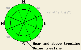
LOW avalanche danger exists at all elevations and on all aspects. Use normal caution when traveling in the backcountry. Human triggered avalanches remain unlikely, but not impossible above 8,000' on steep NW-N-NE-E aspects. |
|
|
|
The high pressure ridge over the region will allow the sunny and relatively warm weather to continue today. The forecast calls for daytime highs in the upper 30's and low 40's above 7000 ft today. The winds should start to shift due to a low pressure system approaching the Pacific coast. Even though this system should not bring any precipitation to the region, it should cause an increase in southwest winds and some increase in cloud cover tomorrow.
On W-SW-S-SE aspects, barely any snow exists. On the NW-N-NE-E aspects in most places a weak, shallow snowpack consisting of facets and some deteriorating crusts exists. In these areas surface conditions depend on aspect, elevation, and exposure and range from thin breakable crusts to warm wet snow, wind scoured ice, and soft "recycled" powder. North of I-80 above 7500 ft more consistent snow coverage exists and "recycled" powder conditions remain on the shaded and sheltered northerly aspects (more info). Yesterday on Red Lake Peak (Carson Pass area), snow depths in the sheltered areas above 8500 ft. ranged from 3-18 inches. Significant wind scouring had removed large amounts of snow from the exposed N-NE aspects leaving behind more exposed rocks. Observations indicated that faceting continues to occur throughout the snowpack on the northerly aspects in this area. This process has caused the upper layers of the snowpack to lose enough strength that they no longer represent slab layers in many places on Red Lake Peak. A few small disconnected hard wind slabs also existed on the snow surface above 9200 ft.
Avalanche Concerns: Persistent slabs
Avalanche activity requires a slab and a weak layer. A persistent weak layer exists in the form of the faceted snow that comprises most of the snowpack. Luckily as the snowpack has faceted, the slab that used to exist on top of the facets has changed into more weak facets in most places. The strong N-NE-E winds have also removed both the weak layer and the slab from many of the exposed N-NE-E facing starting zones. In many areas where a slab and a weak layer exist, anchors poking through a shallow snowpack disrupt the weak layer and hold the snowpack in place. These three things have decreased the size and distribution of areas where instability exists in the snowpack; however, pockets of instability may still remain. As the snowpack continues to change, it will do so sporadically leaving patches of instability scattered amongst areas of more stable snow. Avalanche activity remains unlikely but not impossible today. Steep poorly anchored slopes above 8,000 ft. either above or below treeline on NW-N-NE-E aspects still warrant extra caution.
LOW avalanche danger exists at all elevations and on all aspects. Use normal caution when traveling in the backcountry. Human triggered avalanches remain unlikely, but not impossible above 8,000' on steep NW-N-NE-E aspects.
| 0600 temperature: | 28-30 deg. F. |
| Max. temperature in the last 24 hours: | 34-38 deg. F. |
| Average wind direction during the last 24 hours: | East northeast |
| Average wind speed during the last 24 hours: | 25 mph |
| Maximum wind gust in the last 24 hours: | 48 mph |
| New snowfall in the last 24 hours: | O inches |
| Total snow depth: | 6-20 inches |
For 7000-8000 ft: |
|||
| Friday: | Friday Night: | Saturday: | |
| Weather: | Sunny | Clear | Partly cloudy |
| Temperatures: | 37-44 deg. F. | 20-26 deg. F. | 37-44 deg. F. |
| Wind direction: | Southeast | Southeast | Southwest |
| Wind speed: | around 10 mph | around 10 mph | around 10 mph with gusts to 20 mph in the afternoon |
| Expected snowfall: | O in. | O in. | O in. |
For 8000-9000 ft: |
|||
| Friday: | Friday Night: | Saturday: | |
| Weather: | Sunny | Clear | Partly cloudy |
| Temperatures: | 36-43 deg. F. | 19-26 deg. F. | 34-41 deg. F. |
| Wind direction: | Southeast | Southeast | Southwest |
| Wind speed: | 10-15 mph with gusts to 25 mph | 10-15 mph | 10-20 mph with gusts to 30 mph |
| Expected snowfall: | O in. | O in. | O in. |


This website is owned and maintained by the non-profit arm of the Sierra Avalanche Center. Some of the content is updated by the USDA avalanche forecasters including the forecasts and some observational data. The USDA is not responsible for any advertising, fund-raising events/information, or sponsorship information, or other content not related to the forecasts and the data pertaining to the forecasts.

