In partnership with: 
|
December 10, 2011 at 7:21 am |
|
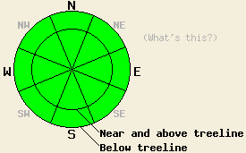
Avalanche danger is LOW for all elevations and aspects. Normal caution is advised. |
|
|
|
Sunny skies and warm air temperatures will continue today. An approaching weather system that is expected to pass to the west and south of the forecast area over the next couple of days has caused ridgetop winds to shift from the east to the southwest overnight. Winds will stay light through the morning hours before increasing to light to moderate in speed this afternoon. An air temperature inversion this morning has near to above freezing temperatures at the upper elevations. Remote sensors around 8,500' are reporting air temperatures in the low to upper 30s. Daytime highs are once again expected to climb into the 30s and 40s for areas above 7,000' today. Increasing cloud cover and cooler air temperatures are forecast for tomorrow.
Recent observations from around the forecast area plus those made yesterday on Lincoln Ridge (Yuba Pass area) all tell a similar story. Very little to no snow exists on SE-S-SW-W aspects. On the NW-N-NE-E aspects, a few different snowpack situations exist. There is either bare ground from wind scouring by east winds, a very shallow snowpack with lots of anchoring, a slightly deeper snowpack that is highly faceted and lacks an overlying slab, or fairly stable hard slabs over facets. Occasionally, snowpit data has pointed towards isolated areas of ongoing instability due to the November 18 facet layer. This is not surprising as this is a persistent weak layer that will remain weak for some time to come.
Avalanche Concerns: Persistent slabs
Natural and human triggered avalanche activity is unlikely at this time. Unlikely is very different from impossible. While widespread stable snowpack conditions do exist, finding a very isolated pocket of instability where one could create a human triggered avalanche remains possible. The snowpack contains a persistent weak layer so it does not really matter that it has not snowed in weeks. The November 18 facet layer exists in most areas and certainly in those areas that hold a sufficiently deep snowpack for over snow recreation. Most of the remaining slabs that have not faceted away are hard slabs. Some of these hard slabs have sufficient anchoring, but isolated pockets that lack anchoring and have an underlying weak layer do exist out there. They are generally few and far between and exist within surrounding areas of seemingly stable snow. Travel smart and exercise appropriate caution in the backcountry in order to minimize risk.
| 0600 temperature: | 31 to 37 deg. F. |
| Max. temperature in the last 24 hours: | 39 to 45 deg. F. |
| Average wind direction during the last 24 hours: | East shifting to southwest. |
| Average wind speed during the last 24 hours: | 15 mph |
| Maximum wind gust in the last 24 hours: | 25 mph |
| New snowfall in the last 24 hours: | O inches |
| Total snow depth: | 6 to 20 inches |
For 7000-8000 ft: |
|||
| Saturday: | Saturday Night: | Sunday: | |
| Weather: | Sunny skies in the morning, becoming partly cloudy. | Partly cloudy skies. | Partly cloudy skies in the morning, becoming mostly cloudy. |
| Temperatures: | 36 to 43 deg. F. | 22 to 28 deg. F. | 28 to 35 deg. F. |
| Wind direction: | SW | W | SW |
| Wind speed: | Light winds becoming around 10 mph in the afternoon. | Around 10 mph in the evening becoming light. | Light winds becoming around 10 mph in the afternoon. |
| Expected snowfall: | O in. | O in. | O in. |
For 8000-9000 ft: |
|||
| Saturday: | Saturday Night: | Sunday: | |
| Weather: | Sunny skies in the morning, becoming partly cloudy. | Partly cloudy skies. | Partly cloudy skies in the morning, becoming mostly cloudy. |
| Temperatures: | 34 to 41 deg. F. | 19 to 26 deg. F. | 23 to 30 deg. F. |
| Wind direction: | SW | SW | SW |
| Wind speed: | 10 to 20 mph. Gusts to 30 mph in the afternoon. | 10 to 15 mph. Gusts to 25 mph after midnight. | 10 to 15 mph with gusts to 30 mph. |
| Expected snowfall: | O in. | O in. | O in. |


This website is owned and maintained by the non-profit arm of the Sierra Avalanche Center. Some of the content is updated by the USDA avalanche forecasters including the forecasts and some observational data. The USDA is not responsible for any advertising, fund-raising events/information, or sponsorship information, or other content not related to the forecasts and the data pertaining to the forecasts.

