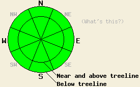
This Avalanche Advisory was published on December 15, 2011:

|
December 15, 2011 at 8:00 am |
|
LOW avalanche danger exists on all elevations and at all aspects. Use normal caution when traveling in the backcountry. |
|
|
|
Forecast Discussion:
A fast-moving, cold low pressure system should pass through the forecast area this morning. The winds shifted to the west yesterday and increased ahead of this system. These winds should continue to clock around to the southwest this morning. After the low pressure moves away from the area the winds should remain strong but shift back to the northeast for this afternoon and tomorrow. This low pressure system should also keep temperatures cold today with daytime highs in the low to mid 20's. Cloud cover has increased across the region due to this system, and a chance of snow showers does exist for today. The forecast only calls for light accumulations along the Sierra Crest with up to one inch of new snow possible. By this afternoon the snow showers and cloud cover should start to dissipate as another high pressure starts to build over the region.
Across the forecast area observations indicate that the snowpack continues to weaken due to faceting. In many areas this process has turned whatever slabs and crusts once existed on top of the snowpack into weak unconsolidated snow. Snow coverage remains limited to the northerly aspects and weak facets exist near the base of the snowpack on these aspects. On several exposed N-NE-E aspects near and above treeline observations have shown that the NE-E winds either stripped the upper layers of snow away or removed all of the snow. In most places rocks, logs, stumps, and other anchors extend through the shallow snowpack. Observations on the NW-N-NE aspects above Five Lakes yesterday showed similar conditions. The more sheltered NW-N-NE aspects above 7500 ft in this area had a snowpack consisting of facets with a deteriorating breakable rain crust on top of them. On more open areas, large feathery surface hoar had formed on the top of the snowpack (photo and snowpit). Isolated hard slabs remain in a few scattered areas around the region on some NW-N-NE-E aspects. Snowpit tests from these isolated areas continue to show that fractures can propagate through the facets underlying these slabs (video from Castle Peak).
Avalanche Concerns: Persistent slabs
Very few areas exist where a slab remains on top of the weak facets. The light snowfall today should not add enough new snow for widespread new slabs to form, keeping avalanche activity unlikely for now. Even though avalanche activity remains unlikely, one of the key ingredients for avalanches will remain. The persistent weak layer at the base of the snowpack still exists, and it could easily reactive whenever a significant snow load arrives. Unlikely does not mean impossible. Some isolated areas where hard slabs have survived on poorly anchored slopes still exist. Weak faceted snow exists under these hard slabs. The right trigger in the right place may be enough to break one of these slabs loose. These slabs exist in areas of seemingly stable snow. Travel smart and exercise appropriate caution in the backcountry in order to minimize risk.
The bottom line:
LOW avalanche danger exists on all elevations and at all aspects. Use normal caution when traveling in the backcountry.
Weather Observations from along the Sierra Crest between 8200 ft and 8800 ft:
| 0600 temperature: | 15-19 deg. F. |
| Max. temperature in the last 24 hours: | 31-38 deg. F. |
| Average wind direction during the last 24 hours: | West |
| Average wind speed during the last 24 hours: | 25 mph |
| Maximum wind gust in the last 24 hours: | 45-60 mph |
| New snowfall in the last 24 hours: | O inches |
| Total snow depth: | 6-20 inches |
Two-Day Mountain Weather Forecast - Produced in partnership with the Reno NWS
For 7000-8000 ft: |
|||
| Thursday: | Thursday Night: | Friday: | |
| Weather: | Occasional snow showers in the morning becoming partly cloudy with isolated snow showers in the afternoon | Partly cloudy | Sunny |
| Temperatures: | 25-31 deg. F. | 11-18 deg. F. | 25-32 deg. F. |
| Wind direction: | Southwest shifting to the northeast in the afternoon | Northeast | East |
| Wind speed: | 10-20 mph with gusts to 35 mph | 15-25 mph with gusts to 40 mph | 15-20 mph with gusts to 35 mph |
| Expected snowfall: | up to 1 in. | O in. | O in. |
For 8000-9000 ft: |
|||
| Thursday: | Thursday Night: | Friday: | |
| Weather: | Occasional snow showers in the morning becoming partly cloudy with isolated snow showers in the afternoon | Partly cloudy | Sunny |
| Temperatures: | 19-25 deg. F. | 11-18 deg. F. | 21-28 deg. F. |
| Wind direction: | Southwest shifting to the northeast in the afternoon | Northeast | East |
| Wind speed: | 15-30 mph with gusts to 50 mph | 25-40 mph with gusts to 70 mph | 20-35 mph with gusts to 60 mph decreasing to gusts to 50 mph in the afternoon |
| Expected snowfall: | up to 1 in. | O in. | O in. |


