In partnership with: 
|
December 18, 2011 at 7:45 am |
|
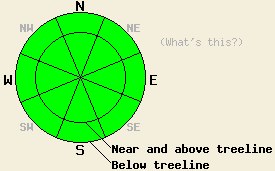
Avalanche danger is LOW for all elevations and aspects. Normal caution is advised. |
|
|
|
Sunny skies will give way to increasing high cloud cover this afternoon. Ridgetop winds have shifted from the east to west this morning. Wind speeds have decreased to light in speed overnight. Light to moderate speed west to northwest winds are expected for this afternoon. Remote sensors along the Sierra Crest at around 8,500' are reporting air temperatures this morning anywhere from the mid 20s to 40deg as an air temperature inversion has set up in most areas. Maximum daytime air temperatures above 7,000' are expected in the mid 30s to low 40s for today. A weak weather system passing through the forecast area tomorrow will cause increased northeast winds and about a ten degree cool down at the mid and upper elevations.
Observations made yesterday on Maggies Peak (Desolation Wilderness area) matched well with other recent observations from around the forecast area (more info). A generally stable snowpack consisting of either faceted snow with no overlying slab or hard slabs over facets and depth hoar exist on snow covered slopes. These snow covered NW-N-NE-E aspects are often well anchored. Exceptions exist as some slopes hold sufficient snow depth to negate the effects of anchoring as the anchors are below the depth of the surface slab. Most snowpit data and informal observations indicate that stable snow is generally widespread. Within that data, occasional indications of isolated areas of instability are noted every few days. As faceted snow is a persistent weak layer, it is no surprise that ongoing areas of isolated instability exist despite not receiving any significant new snowfall in the past month. The SE-S-SW-W aspects are generally void of snow.
Avalanche Concerns: Persistent slabs
With a widespread stable snowpack in place, areas where one could trigger an avalanche are few and far between. That said, the structure of hard slabs over very well developed facets remains disconcerting. Steep northerly aspects that hold a combination of hard slabs and few to no visible anchors are best approached with great caution. Stability evaluation on a slope by slope basis remains a good idea at this time. Most evaluated slopes will not yield evidence of instability. Pay close attention to any evidence of instability that is found and use it to heavily influence decision making in regards to route selection.
| 0600 temperature: | 25 to 40 deg. F. |
| Max. temperature in the last 24 hours: | 37 to 44 deg. F. |
| Average wind direction during the last 24 hours: | East shifting to west. |
| Average wind speed during the last 24 hours: | 21 mph |
| Maximum wind gust in the last 24 hours: | 48 mph |
| New snowfall in the last 24 hours: | O inches |
| Total snow depth: | 6 to 20 inches |
For 7000-8000 ft: |
|||
| Sunday: | Sunday Night: | Monday: | |
| Weather: | Sunny skies in the morning, becoming partly cloudy. | Clear skies. | Sunny skies. |
| Temperatures: | 35 to 42 deg. F. | 17 to 24 deg. F. | 26 to 33 deg. F. |
| Wind direction: | NW | NE | NE |
| Wind speed: | Up to 10 mph in the morning, becoming light. | 10 to 15 mph with gusts to 25 mph. | 15 to 25 mph with gusts to 45 mph. |
| Expected snowfall: | O in. | O in. | O in. |
For 8000-9000 ft: |
|||
| Sunday: | Sunday Night: | Monday: | |
| Weather: | Sunny skies in the morning, becoming partly cloudy. | Clear skies. | Sunny skies. |
| Temperatures: | 34 to 41 deg. F. | 18 to 25 deg. F. | 22 to 29 deg. F. |
| Wind direction: | NW | NE | NE |
| Wind speed: | 10 to 15 mph with gusts to 30 mph in the afternoon. | 10 to 20 mph with gusts to 35 mph. | 25 to 35 mph. Gusts to 55 mph increasing to 65 mph in the afternoon. |
| Expected snowfall: | O in. | O in. | O in. |


This website is owned and maintained by the non-profit arm of the Sierra Avalanche Center. Some of the content is updated by the USDA avalanche forecasters including the forecasts and some observational data. The USDA is not responsible for any advertising, fund-raising events/information, or sponsorship information, or other content not related to the forecasts and the data pertaining to the forecasts.

