In partnership with: 
|
December 23, 2011 at 7:44 am |
|
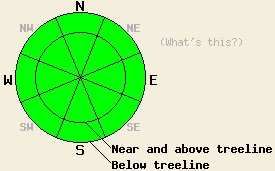
Avalanche danger remains LOW for all elevations and aspects. Normal caution is advised. |
|
|
|
A strong air temperature inversion is in place this morning. Air temperatures along the ridgetops are in the mid to upper 20s while mountain valley floors are in the low single digits and pushing below zero in the coldest areas. Ridgetop winds remain out of the east this morning and have decreased to light in speed. Light winds are forecast to continue through this evening. Maximum daytime air temperatures reaching into the 30s and low 40s are expected for nearly all elevations by this afternoon. A passing short wave will allow for some mid to high level cloud cover to move over the forecast area today.
Observations made yesterday on Lincoln Ridge (Yuba Pass area) matched well with observations made around the rest of the forecast area over the past week (pit profile). The snowpack on NW-N-NE-E aspects is shallow, weak, and wind affected. Significant amounts of faceted snow exist in nearly all areas with varying degrees of overlying slab. In the vast majority of areas, the overlying slab is either too faceted and weak to propagate or it is sufficiently anchored. Recent east wind events have scoured significant amounts of snow from near and above treeline avalanche start zones. What was left behind is either bare ground or stable hard slabs. The SE-S-SW-W aspects are generally void of snow or hold just a few inches in shaded areas.
Avalanche Concerns: Persistent slabs
Despite widespread weak layers in the existing snowpack, the necessary ingredients for avalanche activity are hard to find all in the same place at once. Finding a faceted weak layer is easy, but finding a slab above it that is both unanchored and has the necessary characteristics to propagate is difficult. Steep northerly aspects with few visible anchors remain the suspect areas. Evaluating suspect areas on a slope by slope basis remains prudent at this time. Any evidence of instability should be weighted heavily in the decision make process. Given the current conditions, evidence of instability is unlikely to be seen outside of a snowpit or the aftermath of a human triggered avalanche. Exercise normal caution when traveling in the the backcountry as any human triggered avalanche activity at this time would occur within surrounding areas of stable snow.
Avalanche danger remains LOW for all elevations and aspects. Normal caution is advised.
| 0600 temperature: | 23 to 27 deg. F. |
| Max. temperature in the last 24 hours: | 25 to 27 deg. F. |
| Average wind direction during the last 24 hours: | East |
| Average wind speed during the last 24 hours: | 34 mph |
| Maximum wind gust in the last 24 hours: | 62 mph |
| New snowfall in the last 24 hours: | O inches |
| Total snow depth: | 4 to 20 inches |
For 7000-8000 ft: |
|||
| Friday: | Friday Night: | Saturday: | |
| Weather: | Partly cloudy skies. | Clear skies. | Sunny skies. |
| Temperatures: | 33 to 40 deg. F. | 14 to 20 deg. F. | 35 to 42 deg. F. |
| Wind direction: | E | E | E |
| Wind speed: | Light winds | Light winds increasing to around 10 mph after midnight. | Around 10 mph. |
| Expected snowfall: | O in. | O in. | O in. |
For 8000-9000 ft: |
|||
| Friday: | Friday Night: | Saturday: | |
| Weather: | Partly cloudy skies. | Clear skies. | Sunny skies. |
| Temperatures: | 31 to 37 deg. F. | 20 to 26 deg. F. | 35 to 42 deg. F. |
| Wind direction: | E | NE | E |
| Wind speed: | 10 to 15 mph with gusts to 35 mph in the morning, becoming light. | 10 to 15 mph with gusts to 25 mph after midnight. | 10 to 15 mph. Gusts up to 25 mph in the morning. |
| Expected snowfall: | O in. | O in. | O in. |


This website is owned and maintained by the non-profit arm of the Sierra Avalanche Center. Some of the content is updated by the USDA avalanche forecasters including the forecasts and some observational data. The USDA is not responsible for any advertising, fund-raising events/information, or sponsorship information, or other content not related to the forecasts and the data pertaining to the forecasts.

