In partnership with: 
|
December 26, 2011 at 8:03 am |
|
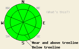
Avalanche danger remains LOW for all elevations and aspects. Normal caution is advised. |
|
|
|
Expect another warm and mostly sunny day over the forecast area. Some clouds should start to develop and the southwest winds should increase as a small low pressure passes north of the region. By tonight the forecast calls for mostly cloudy skies and winds reaching into the 40 mph range along the Sierra Crest. This system should move out of the area by tomorrow, and the winds should subside. Some cloud cover could linger over the region. Warmer than normal temperatures should also remain over the forecast area for the next several days. Daytime highs for today and tomorrow should reach into the low to mid 40's above 7000 ft.
Observations on Mt. Judah yesterday still indicated that all of the layers in the snowpack continue to weaken and facet despite the recent warmer weather (snowpit). The warmer weather combined with scouring by almost a month of N-NE-E winds has caused even more snow to disappear from the already meager snowpack. Across the forecast area on the NW-N-NE-E aspects, the snowpack remains shallow and weak where ever snow exists (photo). In most of these areas, the snowpack consists only of weak snow with no slab on top of it. In most of the isolated areas where a slab does remain on top of the snowpack, observations have shown that either enough anchors extend through the snowpack to hold everything in place or the the slabs remain strong enough to support themselves. The SE-S-SW-W aspects remain dry and rocky except for a few patches of snow in shaded areas (photo).
Avalanche Concerns: Persistent slabs
Avalanche activity remains unlikely because the weak snowpack still has almost no slabs sitting on top of it. The slabs that do still exist usually have enough anchors protruding through the snowpack to hold them in place. In most places a stable snowpack exists and signs of instability remain hard to locate. A few isolated areas on steep northerly slopes that do not have very many anchors could still hold small pockets of possible instability. Snowpit tests can indicate the slopes where these rare patches of instability may remain. Any observations that point towards an unstable snowpack should trump all signs of stability. Continue to travel with caution in the backcountry and evaluate slopes on an individual basis.
Avalanche danger remains LOW for all elevations and aspects. Normal caution is advised.
| 0600 temperature: | 32-36 deg. F. |
| Max. temperature in the last 24 hours: | 37-45 deg. F. |
| Average wind direction during the last 24 hours: | West southwest |
| Average wind speed during the last 24 hours: | 20-30 mph |
| Maximum wind gust in the last 24 hours: | 37 mph |
| New snowfall in the last 24 hours: | O inches |
| Total snow depth: | 4-20 inches |
For 7000-8000 ft: |
|||
| Monday: | Monday Night: | Tuesday: | |
| Weather: | Partly cloudy | Mostly cloudy | Mostly cloudy |
| Temperatures: | 38-45 deg. F. | 18-25 deg. F. | 37-44 deg. F. |
| Wind direction: | Southwest | Southwest | Southwest |
| Wind speed: | 10-15 mph with gusts to 35 mph in the afternoon | 10-15 mph with gusts to 40 mph | around 15 mph with gusts to 30 mph |
| Expected snowfall: | O in. | O in. | O in. |
For 8000-9000 ft: |
|||
| Monday: | Monday Night: | Tuesday: | |
| Weather: | Partly cloudy | Mostly cloudy | Mostly cloudy |
| Temperatures: | 39-45 deg. F. | 19-26 deg. F. | 37-43 deg. F. |
| Wind direction: | Southwest | Southwest | West |
| Wind speed: | 20-30 mph with gusts to 50 mph | 30-40 mph decreasing to 20-35 mph with gusts to 55 mph after midnight | 15-20 mph with gusts to 35 mph |
| Expected snowfall: | O in. | O in. | O in. |


This website is owned and maintained by the non-profit arm of the Sierra Avalanche Center. Some of the content is updated by the USDA avalanche forecasters including the forecasts and some observational data. The USDA is not responsible for any advertising, fund-raising events/information, or sponsorship information, or other content not related to the forecasts and the data pertaining to the forecasts.

