In partnership with: 
|
December 27, 2011 at 8:01 am |
|
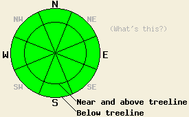
Avalanche danger remains LOW for all elevations and aspects. Use normal caution when traveling in the backcountry. |
|
|
|
One more day of partly sunny, calm, and dry weather should give way to cloudier conditions due to a low pressure system in the Pacific Northwest. The winds should also shift back to the southwest and increase as this system begins to influence the weather this evening. The winds should remain moderate to strong through tomorrow. The increase in clouds could also bring a 20% chance of some precipitation. The northern part of the forecast area along the Sierra Crest has the best chances for precipitation. Due to the warmer temperatures snow levels should remain fairly high between 7500 and 8500 ft. Even though a slight chance of rain and snow does exist through tomorrow, measurable accumulation remains unlikely. The forecast calls for up to 1/10th of an inch of snow at best.
Yesterday on Ralston Peak (photo) and Talking Mountain (photo), observations showed that the scouring N-NE-E winds had removed significant amounts of snow from any of the open and exposed N-NE-E facing slopes. This scouring only left behind a few patches of continuous snow. In most patches of bare ground, rocks and other anchors poked through the snowpack. These conditions match well with other observations around the forecast area showing much less less snow on the higher elevation open slopes due to wind scouring. Other recent observations indicate that the snowpack remains shallow and weak on the NW-N-NE-E aspects where ever snow exists across the forecast area despite the recent warmer weather. In most of these areas, the snowpack consists only of weak snow with no slab on top of it. In most of the isolated areas where a slab does remain on top of the snowpack, observations and snowpit data point to a mostly stable snowpack. The SE-S-SW-W aspects remain dry and rocky except for a few patches of snow in shaded areas.
Avalanche Concerns: Persistent slabs
Avalanche activity remains unlikely because the weak snowpack still has almost no slabs sitting on top of it. The slabs that do still exist usually have enough anchors protruding through the snowpack to hold them in place or they remain strong enough to hold themselves in place. In most places a stable snowpack exists and signs of instability remain hard to locate. A few isolated areas on steep northerly slopes that do not have very many anchors could still hold small pockets of possible instability. Snowpit tests can indicate the slopes where these rare patches of instability may remain. Any observations that point towards an unstable snowpack should trump all signs of stability. Continue to travel with caution in the backcountry and evaluate slopes on an individual basis.
Avalanche danger remains LOW for all elevations and aspects. Use normal caution when traveling in the backcountry.
| 0600 temperature: | 29-34 deg. F. |
| Max. temperature in the last 24 hours: | 37-42 deg. F. |
| Average wind direction during the last 24 hours: | West southwest shifting to the north and east this morning |
| Average wind speed during the last 24 hours: | 20 mph |
| Maximum wind gust in the last 24 hours: | 50 mph |
| New snowfall in the last 24 hours: | O inches |
| Total snow depth: | 4-20 inches |
For 7000-8000 ft: |
|||
| Tuesday: | Tuesday Night: | Wednesday: | |
| Weather: | Partly cloudy | Mostly cloudy with a slight chance (20%) of rain after midnight. Snow levels rising to 8100 ft. | Mostly cloudy with a slight chance (20%) of rain and snow. Snow levels between 7500 and 8500 ft. |
| Temperatures: | 36-43 deg. F. | 19-26 deg. F. | 41-48 deg. F. |
| Wind direction: | Southwest | Southwest | Southwest |
| Wind speed: | 10 mph with gusts to 25 mph | 10-25 mph with gusts to 40 mph | 15-30 mph with gusts to 50 mph |
| Expected snowfall: | O in. | trace to 0 in. | trace to 0 in. |
For 8000-9000 ft: |
|||
| Tuesday: | Tuesday Night: | Wednesday: | |
| Weather: | Partly cloudy | Mostly cloudy with a slight chance (20%) of rain and snow after midnight. Snow level 8100 ft. | Mostly cloudy with a slight chance (20%) of snow. Snow levels between 7500 and 8500 ft. |
| Temperatures: | 33-40 deg. F. | 21-28 deg. F. | 38-45 deg. F. |
| Wind direction: | Southwest | Southwest | West |
| Wind speed: | 15-25 mph with gusts to 35 mph | 20-30 mph with gusts to 45 mph | 20-35 mph with gusts to 55 mph |
| Expected snowfall: | O in. | trace to 0 in. | trace to 0 in. |


This website is owned and maintained by the non-profit arm of the Sierra Avalanche Center. Some of the content is updated by the USDA avalanche forecasters including the forecasts and some observational data. The USDA is not responsible for any advertising, fund-raising events/information, or sponsorship information, or other content not related to the forecasts and the data pertaining to the forecasts.

