In partnership with: 
|
December 29, 2011 at 8:01 am |
|
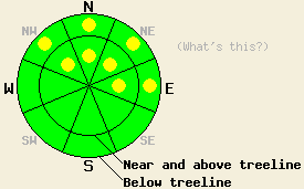
Pockets of MODERATE avalanche danger exist above 7,500' on NW-N-NE-E aspects on slopes 37 degrees and steeper. For all other areas, avalanche danger remains LOW. |
|
|
|
The weather system that has brought cloud cover and traces of rain and very high elevation snow to the forecast area will move out of the region later today. Warm air associated with this system has continued above freezing air temperatures around the clock. Cloud cover last night has aided in keeping air temperatures at or above freezing at remote sensor sites across the forecast area from 6,000 to 9,650'. Despite ongoing cloud cover, maximum daytime air temperatures are expected to climb into the mid 40s to mid 50s today for nearly all elevations. Light to moderate southwest to west winds are expected to continue through today. A new weather system is forecast to bring additional chances of light rain and snow along with strong to gale force ridgetop winds to the forecast area tomorrow.
Observations made yesterday on Carpenter Ridge (Independence Lake area) revealed significant wet snow on all NW-N-NE-E aspects up to the highest elevation traveled of 8,520' (pit profile, more info). The 4 to 6 inches of wet surface snow sat on top of well developed faceted snow that was increasing in moisture content and beginning to round under the influence of warmer snowpack temperatures. Very minimal amounts of skier triggered wet loose snow sluffing was noted off of turns on a NNW aspect just below treeline slope with a 30 degree slope angle. Observations from the Mount Rose area indicated that wet snow existed up to 9,600', with the notable difference that the overall shallower snowpack in that area was wet from top to bottom. Across the forecast area little to no snow exists on SE-S-SW-W aspects.
Avalanche Concerns: Wet loose avalanches
The combination of overnight cloud cover and above freezing air temperatures is expected to have kept any significant refreeze of the snowpack from occurring last night. Some additional trace amounts of rain have fallen last night in some areas as well. Human triggered wet loose avalanche activity is possible today above 7,500' on NW-N-NE-E aspects on slopes 37 degrees and steeper. Areas along the Sierra Crest in the northern portion of the forecast area that hold a deeper snowpack with wet snow over basal facets have the greatest chances for instability. Throughout the rest of the forecast area, isolated pockets of terrain with sizeable patches of snow and few visible anchors will also allow for a greater possibility of avalanche activity today.
Pockets of MODERATE avalanche danger exist above 7,500' on NW-N-NE-E aspects on slopes 37 degrees and steeper. For all other areas, avalanche danger remains LOW.
| 0600 temperature: | 33 to 36 deg. F. |
| Max. temperature in the last 24 hours: | 39 to 47 deg. F. |
| Average wind direction during the last 24 hours: | southwest |
| Average wind speed during the last 24 hours: | 21 mph |
| Maximum wind gust in the last 24 hours: | 47 mph |
| New snowfall in the last 24 hours: | rain, trace to 0.1 inches |
| Total snow depth: | 3 to 19 inches |
For 7000-8000 ft: |
|||
| Thursday: | Thursday Night: | Friday: | |
| Weather: | Mostly cloudy skies. | Mostly cloudy skies. | Mostly cloudy skies with a chance of rain and snow. |
| Temperatures: | 48 to 54 deg. F. | 28 to 35 deg. F. | 42 to 48 deg. F. |
| Wind direction: | W | SW | SW |
| Wind speed: | 10 to 20 mph with gusts to 40 mph. | 10 to 20 mph with gusts to 40 mph. Gusts increasing to 50 mph after midnight. | 20 to 35 mph with gusts to 60 mph. Winds increasing to 30 to 45 mph with gusts to 80 mph in the afternoon. |
| Expected snowfall: | O in. | O in. | 0 to trace in. |
For 8000-9000 ft: |
|||
| Thursday: | Thursday Night: | Friday: | |
| Weather: | Mostly cloudy skies. | Mostly cloudy skies. | Mostly cloudy skies with a chance of rain and snow in the morning. Cloudy skies with a chance of snow in the afternoon. |
| Temperatures: | 42 to 48 deg. F. | 26 to 33 deg. F. | 37 to 43 deg. F. |
| Wind direction: | W | SW | SW |
| Wind speed: | 20 to 35 mph with gusts to 50 mph. | 20 to 35 mph with gusts to 50 mph. Gusts increasing to 65 mph after midnight. | 30 to 50 mph with gusts to 80 mph. Winds increasing to 45 to 65 mph with gusts to 110 mph in the afternoon. |
| Expected snowfall: | O in. | O in. | 0 to trace in. |


This website is owned and maintained by the non-profit arm of the Sierra Avalanche Center. Some of the content is updated by the USDA avalanche forecasters including the forecasts and some observational data. The USDA is not responsible for any advertising, fund-raising events/information, or sponsorship information, or other content not related to the forecasts and the data pertaining to the forecasts.

