In partnership with: 
|
December 31, 2011 at 8:00 am |
|
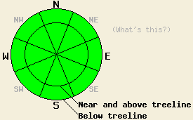
LOW avalanche danger exists on all aspects and at all elevations. Use normal caution when traveling in the backcountry. The next update to this advisory will occur on Jan. 2nd at 7 am. |
|
|
|
Yesterday's weather system did bring a small amount of precipitation to the region. Most of this precipitation fell as rain with some very light snow accumulation at the upper elevations. Total precipitation amounts ranged from a trace to 1/10th of an inch of water equivalent, which equaled less than an inch of snow at the upper elevations. Above 7500 ft. temperatures have remained near or below freezing since yesterday afternoon. The clouds started to dissipate yesterday afternoon and the strong winds associated with this system began to decrease. This morning temperatures have started to climb, winds continue to decrease, and the clouds continue to disperse due to a high pressure ridge building over the forecast area. This ridge should keep temperatures warm, winds light, and skies partly sunny through early next week. Daytime highs today could reach into the mid to upper 40's above 7000 ft. These highs should continue to warm a few degrees each day for the next few days. By Monday daytime highs could climb into the low to mid 50's above 7000 ft. The forecast also calls for the overnight lows to continue to drop below freezing tonight, tomorrow night, and Monday night.
Observations over the last few days have shown that the weak facets once prevalent in the snowpack have quickly changed into rounded clusters of wet snow. So far observations have shown this change occurring as high as 8200 ft. Yesterday observations on Silver Peak (photos and snowpit) and on Lincoln Ridge (Yuba Pass area - video and snowpit) showed a snowpack consisting of a refrozen crust a few inches thick sitting on top of wet snow below it. This crust remained variable in strength. In some places a person could easily break through it, while in other areas it could support a person's weight. Snowpit tests in both of these areas did indicate that the snow below this crust remains wet and weak in some places. On Lincoln Ridge two of the tests even indicated that if this layer breaks the resulting fracture could travel along this layer.
Avalanche Concerns:
Even though the warm and moist weather has caused the meager snowpack to shrink even more, it has also started to destroy the weak faceted snow that has plagued the region all season. As the water in the snowpack freezes, the entire snowpack including once persistent weak layer should become much stronger due to the icy bonds that form within the snowpack. Last night's freezing temperatures and less cloudy skies should have allowed a good refreeze to occur over the last 16 hours. As daytime highs climb well above freezing today and tomorrow, a few wet surface snow instabilities like roller balls and pinwheels may form druing the afternoons on the most sun exposed slopes. However, the weak winter sun should not cause enough melting for widespread wet snow instabilities to form. Avalanche activity should remain unlikely. A few rare and very isolated patches of snowpack instability may remain on some of the highest elevation northerly aspects where warming has not destroyed the facets and where few anchors exist to hold the snowpack in place. Travel with caution in the backcountry.
LOW avalanche danger exists on all aspects and at all elevations. Use normal caution when traveling in the backcountry. The next update to this advisory will occur on Jan. 2nd at 7 am.
| 0600 temperature: | 32-35 deg. F. |
| Max. temperature in the last 24 hours: | 34-39 deg. F. |
| Average wind direction during the last 24 hours: | West Southwest |
| Average wind speed during the last 24 hours: | 35 mph |
| Maximum wind gust in the last 24 hours: | 87 mph |
| New snowfall in the last 24 hours: | trace to 1 inches |
| Total snow depth: | 2-18 inches |
For 7000-8000 ft: |
|||
| Saturday: | Saturday Night: | Sunday: | |
| Weather: | Partly cloudy | Partly cloudy | Partly cloudy |
| Temperatures: | 38-45 deg. F. | 25-33 deg. F. | 46-53 deg. F. |
| Wind direction: | Southwest | Southeast | East shifting to the south in the afternoon |
| Wind speed: | up to 10 mph | up to 10 mph | around 10 mph |
| Expected snowfall: | O in. | O in. | O in. |
For 8000-9000 ft: |
|||
| Saturday: | Saturday Night: | Sunday: | |
| Weather: | Partly cloudy | Partly cloudy | Partly cloudy |
| Temperatures: | 40-46 deg. F. | 28-34 deg. F. | 44-51 deg. F. |
| Wind direction: | Southwest | Southwest | East shifting to the south in the afternoon |
| Wind speed: | 10-15 mph with gusts to 30 mph in the morning | 10-15 mph with gusts to 25 mph in the evening decreasing overnight | around 10 mph with gusts to 25 mph in the afternoon |
| Expected snowfall: | O in. | O in. | O in. |


This website is owned and maintained by the non-profit arm of the Sierra Avalanche Center. Some of the content is updated by the USDA avalanche forecasters including the forecasts and some observational data. The USDA is not responsible for any advertising, fund-raising events/information, or sponsorship information, or other content not related to the forecasts and the data pertaining to the forecasts.

