In partnership with: 
|
January 5, 2012 at 7:31 am |
|
LOW avalanche danger exists for all elevations and aspects. Normal caution is advised. |
|
|
|
The streak of above average air temperatures and possible record setting daytime maximum air temperatures continues today. Moderate speed southwest to west winds are forecast to continue today and tomorrow. An air temperature inversion has most locations above 6,500' in the mid 30s to low 40s this morning. Similar to yesterday, the upper elevations have a good head start on warming today with daytime highs in the 40s and 50s expected for nearly all elevations. A slow increase in high cloud cover is expected today and tonight as the fringe of a weather system passing through southern Canada shows over the forecast area. A cooling trend associated with an inside slider type weather system passing to the east of the forecast area will decrease maximum daytime air temperatures about ten degrees for Friday.
Recent observations from around the forecast area, including those made yesterday on Barker Peak (Blackwood Canyon area) continue to show a stabilizing trend in the existing snowpack. The warming and rain event that occurred on December 28-29 added free water to the snowpack. This free water allowed for significant rounding and bonding of faceted snow that had existed for most of the season in the middle and lower portions of the snowpack. As the snowpack has refrozen over the past week, the entire snowpack has gained strength (video, more info). This significant structural change and increase in strength has been noted along the Sierra Crest up to at least 9,000'. Most areas above 9,000' have been significantly wind scoured. Isolated snow covered areas above 9,000' and other areas further south that picked up less free water during the melt and rain event are still covered with a rain or melt freeze crust. In some areas there are still loose facets below the crust, but the overall snowpack in these areas tends to be shallow, patchy, and well anchored. Across the forecast area, snow surface conditions in most areas range from breakable to supportable crust anywhere from 1/2 inch to 18 inches thick.
Avalanche Concerns:
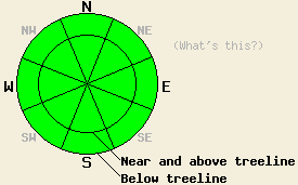
Avalanche concerns at this time are few. The Dec 28-29 warming event created significant changes in the existing snowpack, especially north of Hwy 80 in what were the most worrisome areas. Now that the persistent weak layer of basal facets has been mostly destroyed, a strong and stable snowpack exists in most snow covered areas. Despite warm daytime air temperatures, wet snow instability is not expected to form on NW-N-NE-E aspects due to weak solar radiation at this time of year. SE-S-SW-W aspects are generally void of snow, negating concerns for wet snow instability on the aspects that receive the highest amounts of solar radiation.
LOW avalanche danger exists for all elevations and aspects. Normal caution is advised.
| 0600 temperature: | 34 to 40 deg. F. |
| Max. temperature in the last 24 hours: | 49 to 53 deg. F. |
| Average wind direction during the last 24 hours: | Southwest |
| Average wind speed during the last 24 hours: | 20 mph |
| Maximum wind gust in the last 24 hours: | 32 mph |
| New snowfall in the last 24 hours: | O inches |
| Total snow depth: | 2 to 18 inches |
For 7000-8000 ft: |
|||
| Thursday: | Thursday Night: | Friday: | |
| Weather: | Partly cloudy skies. | Partly cloudy skies in the evening, becoming mostly cloudy. | Partly cloudy skies. |
| Temperatures: | 48 to 54 deg. F. | 30 to 36 deg. F. | 37 to 44 deg. F. |
| Wind direction: | SW | SW | W |
| Wind speed: | 10 to 15 mph with gusts to 30 mph. | 10 to 15 mph with gusts to 30 mph. | Light winds |
| Expected snowfall: | O in. | O in. | O in. |
For 8000-9000 ft: |
|||
| Thursday: | Thursday Night: | Friday: | |
| Weather: | Partly cloudy skies. | Partly cloudy skies in the evening, becoming mostly cloudy. | Partly cloudy skies. |
| Temperatures: | 42 to 50 deg. F. | 27 to 34 deg. F. | 33 to 40 deg. F. |
| Wind direction: | SW | SW | W |
| Wind speed: | 20 to 30 mph with gusts to 45 mph. | 20 to 30 mph with gusts to 50 mph. | 10 to 15 mph with gusts to 30 mph. |
| Expected snowfall: | O in. | O in. | O in. |


This website is owned and maintained by the non-profit arm of the Sierra Avalanche Center. Some of the content is updated by the USDA avalanche forecasters including the forecasts and some observational data. The USDA is not responsible for any advertising, fund-raising events/information, or sponsorship information, or other content not related to the forecasts and the data pertaining to the forecasts.

