In partnership with: 
|
January 9, 2012 at 7:45 am |
|
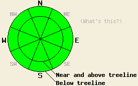
LOW avalanche danger exists for all elevations and aspects. Normal caution is advised. |
|
|
|
The ridge of high pressure currently over the forecast are will flatten a bit today in response to a weather system well to the north of the region. As a result sunny skies, above freezing air temperatures, and light winds are expected for the high country today. Air temperatures this morning are in the low to mid 30s above 7,000'. Maximum daytime air temperatures in the 40s are forecast for the mid and upper elevations today. Ridgetop winds remain out of the east this morning and have decreased to light to moderate in speed. Light winds are forecast for today. An increase in cloud cover and cooler air temperatures are expected for tonight and tomorrow as a splitting weather system approaches the coast.
Recent observations from around the forecast area including those made yesterday on Mt. Judah (Donner Summit area) continue to show a fair bit of variability in the snowpack. Overall the snowpack is shallow with any significant amounts of snow limited to NW-N-NE-E aspects. There is significantly more snow along the Sierra Crest in the northern half to third of the forecast area than in other locations. Most areas saw a significant change in the existing snowpack following the December 28-29 warming and rain event. In many areas the now refrozen snowpack is a strong and stable mix of crusts and rounds. Faceting processes are at work to varying degrees below the rain crust in these areas. In other areas where little to no rain fell such as south of Barker Pass, on the east side of Lake Tahoe, and at high elevations weak faceted snow remains underneath the existing surface crust. In these areas, the snowpack is very shallow, patchy, and well anchored and therefore not a significant concern at this time. Isolated areas of fairly stable hard slab over faceted snow exist in a few areas on northerly aspects above 9,000' that were not scoured to bare ground during the December wind events. Areas on SE-S-SW-W aspects are generally void of snow except for a few small shallow patches in heavily shaded areas.
Avalanche Concerns:
Avalanche concerns at this time are few. While some very isolated areas of a weak faceted layer with an overlying slab exist, triggering snowpack failure in these areas and creating an avalanche remains unlikely. The snowpack continues to change a little bit each day. Time will tell if the weak layers forming now will come to into play in the future or will be destroyed by future weather events before they are loaded by significant snowfall. Sliding falls on icy slopes leading to impact with exposed rocks and trees remains the biggest hazard to backcountry travelers.
LOW avalanche danger exists for all elevations and aspects. Normal caution is advised.
| 0600 temperature: | 31 to 35 deg. F. |
| Max. temperature in the last 24 hours: | 37 to 44 deg. F. |
| Average wind direction during the last 24 hours: | East |
| Average wind speed during the last 24 hours: | 27 mph |
| Maximum wind gust in the last 24 hours: | 53 mph |
| New snowfall in the last 24 hours: | O inches |
| Total snow depth: | 0 to 18 inches |
For 7000-8000 ft: |
|||
| Monday: | Monday Night: | Tuesday: | |
| Weather: | Sunny skies. | Partly cloudy skies. | Mostly cloudy skies. |
| Temperatures: | 42 to 49 deg. F. | 25 to 32 deg. F. | 36 to 43 deg. F. |
| Wind direction: | E shifting to S in the afternoon. | SW | SW shifting to NE in the afternoon. |
| Wind speed: | Up to 10 mph. | Around 10 mph. | Around 10 mph. |
| Expected snowfall: | O in. | O in. | O in. |
For 8000-9000 ft: |
|||
| Monday: | Monday Night: | Tuesday: | |
| Weather: | Sunny skies. | Partly cloudy skies. | Mostly cloudy skies. |
| Temperatures: | 39 to 46 deg. F. | 23 to 31 deg. F. | 31 to 38 deg. F. |
| Wind direction: | E shifting to S in the afternoon. | SW | W shifting to NE in the afternoon. |
| Wind speed: | 10 to 15 mph. | 10 to 15 mph with gusts to 25 mph. | 10 to 15 mph with gusts to 25 mph. |
| Expected snowfall: | O in. | O in. | O in. |


This website is owned and maintained by the non-profit arm of the Sierra Avalanche Center. Some of the content is updated by the USDA avalanche forecasters including the forecasts and some observational data. The USDA is not responsible for any advertising, fund-raising events/information, or sponsorship information, or other content not related to the forecasts and the data pertaining to the forecasts.

