In partnership with: 
|
January 11, 2012 at 7:48 am |
|
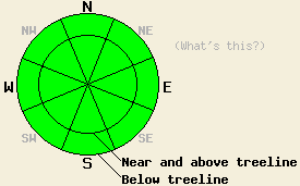
LOW avalanche danger exists for all elevations and aspects. Normal caution is advised. |
|
|
|
High pressure will strength over the forecast area today. This will lead to sunny skies and light winds for the next few days. An air temperature inversion is in place this morning with the coldest air below 7,000'. Daytime warming will push most locations into the 30s to mid 40s, with a few 50s possible between 7,000 and 8,000'. Light winds out east this morning are expected to become light and variable to calm as the day progresses. Similar conditions are expected for tomorrow with max temps in the 30s to low 40s, but with morning winds out of the west.
Recent observations from around the forecast area including those made yesterday in Upper Ophir Creek (Mount Rose area) continue to show a fair bit of variability in the snowpack (pit profiles, photos, more info). Overall the snowpack is shallow with any significant amounts of snow limited to NW-N-NE-E aspects. All of these snow covered areas hold some form of rain or melt freeze surface crust, either supportable or breakable. There is significantly more snow along the Sierra Crest in the northern half to third of the forecast area than in other locations. Many areas saw a significant change in the existing snowpack following free water introduction associated with the December 28-29 warming and rain event. In these areas the now refrozen snowpack is a strong and stable mix of crusts and rounds. Faceting processes are at work to varying degrees below the rain crust in these areas. In other areas where little to no rain fell such as south of Barker Pass, on the east side of Lake Tahoe, and at high elevations, weak faceted snow remains underneath the existing surface crust. In these areas, the snowpack is very shallow, patchy, generally well anchored and therefore not a significant concern at this time. Isolated areas of fairly stable hard slab over faceted snow exist in a few areas on northerly aspects above 9,000' that were not scoured to bare ground during the December east wind events. Areas on SE-S-SW-W aspects are generally void of snow except for a few small shallow patches in heavily shaded areas.
Avalanche Concerns:
Avalanche concerns at this time are few. While some very isolated areas of a weak faceted layer with an overlying slab exist, triggering snowpack failure in these areas and creating an avalanche remains unlikely. The snowpack continues to change a little bit each day. Time will tell if the weak layers forming now will come to into play in the future or will be destroyed by future weather events before they are loaded by significant snowfall. Sliding falls on icy slopes leading to impact with exposed rocks and trees remains the biggest hazard to backcountry travelers.
LOW avalanche danger exists for all elevations and aspects. Normal caution is advised.
| 0600 temperature: | 25 to 30 deg. F. |
| Max. temperature in the last 24 hours: | 41 to 49 deg. F. |
| Average wind direction during the last 24 hours: | East |
| Average wind speed during the last 24 hours: | 12 mph |
| Maximum wind gust in the last 24 hours: | 26 mph |
| New snowfall in the last 24 hours: | O inches |
| Total snow depth: | 0 to 18 inches |
For 7000-8000 ft: |
|||
| Wednesday: | Wednesday Night: | Thursday: | |
| Weather: | Sunny skies. | Clear skies. | Sunny skies. |
| Temperatures: | 40 to 55 deg. F. | 22 to 28 deg. F. | 38 to 43 deg. F. |
| Wind direction: | E becoming variable | Variable | Variable |
| Wind speed: | 5 to 15 mph | Light winds. | Light winds. |
| Expected snowfall: | O in. | O in. | O in. |
For 8000-9000 ft: |
|||
| Wednesday: | Wednesday Night: | Thursday: | |
| Weather: | Sunny skies. | Clear skies. | Sunny skies. |
| Temperatures: | 32 to 39 deg. F. | 19 to 26 deg. F. | 32 to 38 deg. F. |
| Wind direction: | E becoming variable | Variable winds becoming SW. | W shifting to NE in the afternoon. |
| Wind speed: | 10 to 20 mph with gusts to 30 mph in the morning, decreasing to 10 mph. | Light winds increasing to 10 to 20 mph with gusts to 30 mph after midnight. | 10 to 15 mph. |
| Expected snowfall: | O in. | O in. | O in. |


This website is owned and maintained by the non-profit arm of the Sierra Avalanche Center. Some of the content is updated by the USDA avalanche forecasters including the forecasts and some observational data. The USDA is not responsible for any advertising, fund-raising events/information, or sponsorship information, or other content not related to the forecasts and the data pertaining to the forecasts.

