In partnership with: 
|
January 14, 2012 at 8:01 am |
|
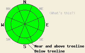
LOW avalanche danger exists for all elevations and aspects. Use normal caution while traveling in the backcountry. |
|
|
|
The forecast calls for one more day of warmer temperatures with daytime highs in the low to mid 40's above 7000 ft. A low pressure passing north of the region combined with an approaching cold front should bring some cloudiness to the area this afternoon, tonight, and tomorrow. The southwest winds have also started to increase ahead of this cold front. They should continue to increase with average speeds between 50 and 60 mph and gusts to 95 mph along the Sierra Crest by tomorrow afternoon. Temperatures should fall as the cold front begins to impact the region. Tonight's lows should drop into the low 20's, and tomorrow's highs should only climb into the low 30's. A slight inversion exists again this morning due to cold air pooling in the valley's below 7000 ft. The increased winds should allow this inversion to lift more quickly than it has over the last few days.
The anemic snowpack remains highly variable from place to place across the region. Snow coverage only exists on the NW-N-NE-E aspects. South of Barker Pass along the Sierra Crest and in areas on the east side of the Lake on these aspects erratic snow coverage exists due to less accumulation during early season storms and significant wind scouring by strong N-NE-E winds. In these more shallow higher elevation areas where less warming occurred, more layers of weak facets exist; however, copious anchors also extend through the snowpack disrupting existing weak layers and holding the snowpack in place in most areas. North of Barker Pass along the Sierra Crest a deeper snowpack exists. Recently in these areas, more rain and warming occurred capping the snowpack with a thick rain crust and creating melt freeze conditions within the snowpack. As the snowpack refroze, it grew much stronger and more stable in most of these areas. Some recent observations have shown weak sugary facets reforming near the rain crusts in isolated areas. Yesterday on Andesite Ridge, observations showed that the warmer weather and rain had transformed the entire snowpack into melt freeze snow except for the top half inch. The water that caused this change has since refrozen leaving a strong stable snowpack behind in much of this area (snowpit). The top half inch of snow has changed into large square sided weak snow grains known as facets (photo).
Avalanche Concerns:
Avalanche activity remains unlikely. Small and very isolated areas where a slab lingers on top of weak snow do still exist. Even where these conditions persist, actually triggering a fracture in the snowpack would prove difficult. Weak layers have shown signs of reforming in some areas. Depending on how widespread and developed these weak layers become, they could create problems when new snow arrives. The avalanche danger remains low, but plenty of other hazards exist in the backcountry including very icy slopes with lots of rocks and trees at the bottom and in the middle of these slopes. Continue to use caution when traveling in the backcountry.
LOW avalanche danger exists for all elevations and aspects. Use normal caution while traveling in the backcountry.
| 0600 temperature: | 33-36 deg. F. |
| Max. temperature in the last 24 hours: | 44-48 deg. F. |
| Average wind direction during the last 24 hours: | Southwest |
| Average wind speed during the last 24 hours: | 10-15 mph |
| Maximum wind gust in the last 24 hours: | 29 mph |
| New snowfall in the last 24 hours: | O inches |
| Total snow depth: | 0-18 inches |
For 7000-8000 ft: |
|||
| Saturday: | Saturday Night: | Sunday: | |
| Weather: | Sunny in the morning becoming partly cloudy in the afternoon | Mostly cloudy | Partly cloudy |
| Temperatures: | 39-46 deg. F. | 20-27 deg. F. | 30-37 deg. F. |
| Wind direction: | Southwest | Southwest | Southwest |
| Wind speed: | 15-20 mph with gusts to 30 mph | 15-25 mph with gusts to 30 mph increasing to 40 mph after midnight | 25-40 mph with gusts to 60 mph |
| Expected snowfall: | O in. | O in. | O in. |
For 8000-9000 ft: |
|||
| Saturday: | Saturday Night: | Sunday: | |
| Weather: | Sunny in the morning becoming partly cloudy in the afternoon | Mostly cloudy | Partly cloudy |
| Temperatures: | 36-43 deg. F. | 20-27 deg. F. | 26-33 deg. F. |
| Wind direction: | Southwest | Southwest | Southwest |
| Wind speed: | 20-30 mph with gusts to 45 mph | 25-35 mph with gusts to 50 mph increasing to 65 mph after midnight | 25-50 mph with gusts to 75 mph increasing to 55-60 mph with gusts to 95 mph in the afternoon |
| Expected snowfall: | O in. | O in. | O in. |


This website is owned and maintained by the non-profit arm of the Sierra Avalanche Center. Some of the content is updated by the USDA avalanche forecasters including the forecasts and some observational data. The USDA is not responsible for any advertising, fund-raising events/information, or sponsorship information, or other content not related to the forecasts and the data pertaining to the forecasts.

