In partnership with: 
|
January 20, 2012 at 8:03 am |
|
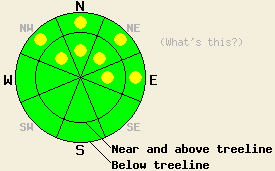
Today isolated pockets of MODERATE danger could exist on the NW-N-NE-E facing slopes steeper than 35 degrees at all elevations where a snowpack exists. As more precipitation occurs over the next few days the avalanche danger will increase and become more widespread. Cautious travel habits and careful snowpack evaluation during this storm cycle can help prevent people from being involved in dangerous avalanches. |
|
|
|
Two to six inches of heavy wet snow fell last night due to the first in a series of storms impacting the region. The areas north of Barker Pass received the highest snowfall amounts while areas east of the Lake and south of Barker Pass received less snow. This morning the forecast calls for a break in the weather with less wind and only showery precipitation before the second and strongest storm in this series arrives this afternoon and evening. As this second system approaches, the southwest winds should increase again with wind speeds averaging between 65 and 70 mph by this afternoon and remaining strong through tomorrow. Snow levels should also climb to between 7500 ft and 8000 ft for the start of this second storm. As the storm moves across the forecast area snow levels should fall to the valley floors overnight. This system has ample precipitation associated with it. Precipitation should begin to intensify this evening and continue through tonight. Below 7500 ft this precip will start as rain before changing over to snow. By tomorrow morning the forecast calls for an additional 12-28 inches of new snow above 7000 ft with four to eight inches at lake level. Another break between the storms should occur tomorrow with the winds and precipitation decreasing during the day. Temperatures should remain cold though due to a mass of cold air behind tonight's storm. Check in with the Reno NWS for more details.
Yesterday on Round Top Peak observations showed conditions similar to previous data from that area. Snow coverage remains limited to the northerly aspects, and even on those aspects it remains patchy with plenty of rocks and sections of bare ground visible (photo). Where the snowpack does exist it consists mostly of impenetrable ice left over from last season with smaller areas where snow from this winter resides on top of last year's snow (photo). This winter's snow consists of a hard supportable wind packed slab on top of weak snow of varying thickness. Observations indicate that it requires a significant amount of force to actually start a fracture below the strong slabs (snowpit). Father north and east observations in the Mt Rose area showed very little snowpack remaining even on the northerly aspects. In this area finding continuous snow cover has become difficult. In this area the snowpack is almost starting from scratch (photos and more info). These two areas represent the southern part of the forecast area and the part of the forecast area east of Lake Tahoe well. However, observations have shown a deeper more complex snowpack farther north along the Sierra Crest on the northerly aspects. In these areas rain and warmer weather formed strong frozen crusts on the snow surface. As colder weather returned, weak faceted snow reformed both above and below these crusts.
Avalanche Concern #1: Wind Slabs and Storm Slabs
The new snow that could fall today plus last night's new snow combined with strong southwest winds could form small wind slabs on the wind loaded NW-N-NE-E aspects near and above treeline. Some of these wind slabs will form on top of a variety of possible weak layers and bed surfaces ranging from a thin layer of weak snow above the crusts to weak facets below breakable crusts to icy surfaces from last year. This combination will provide the necessary ingredients for avalanche activity. The crusts will serve as great bed surfaces, the thin layers of weak snow around the crusts as weak layers, and the new wind slabs as slabs. Pockets of MODERATE avalanche danger where human triggered avalanches become possible could exist in these areas. Even though avalanches caused by this type of instability should remain small and relatively shallow, they could easily push a person into the plethora of rocks and other exposed obstacles remaining on the slopes.
Avalanche Concern #2: Wet Snow Instability:
As rain falls below 7500 ft today and this evening, it will destroy the bonds holding the the snowpack together making wet loose snow avalanches possible. Worrisome instances of this kind instability should remain confined to northerly aspects where a snowpack existed previous to this storm. Any slides resulting from this type of instability should remain small due to the shallow snowpack below 7500ft. However as mentioned above, even a small slide can have serious consequences.
Today isolated pockets of MODERATE danger could exist on the NW-N-NE-E facing slopes steeper than 35 degrees at all elevations where a snowpack exists. As more precipitation occurs over the next few days the avalanche danger will increase and become more widespread. Cautious travel habits and careful snowpack evaluation during this storm cycle can help prevent people from being involved in dangerous avalanches.
| 0600 temperature: | 29-33 deg. F. |
| Max. temperature in the last 24 hours: | 29-34 deg. F. |
| Average wind direction during the last 24 hours: | Southwest |
| Average wind speed during the last 24 hours: | Along the Sierra Crest: 45 mph - In the Mt Rose area: 55 mph |
| Maximum wind gust in the last 24 hours: | Along the Sierra Crest: 84 mph - In the Mt Rose area: 120 mph |
| New snowfall in the last 24 hours: | 2-6 inches |
| Total snow depth: | 3-24 inches |
For 7000-8000 ft: |
|||
| Friday: | Friday Night: | Saturday: | |
| Weather: | Widespread showers consisting of a mix of rain and snow. Snow level around 7500 ft. | Rain and snow in the evening changing to snow after midnight. Snow level around 7500 ft in the evening dropping below 7000 ft after 8 pm. | Snow showers |
| Temperatures: | 32-39 deg. F. | 18-25 deg. F. | 21-28 deg. F. |
| Wind direction: | Southwest | Southwest | Southwest |
| Wind speed: | 25-30 mph with gusts to 45 mph increasing to 40-45 mph with gusts to 65 mph in the afternoon | 50-60 mph with gusts to 90 mph decreasing to 80 mph after midnight | 35-45 mph with gusts to 70 mph |
| Expected snowfall: | up to 4 in. | 12-24 in. | 3-6 in. |
For 8000-9000 ft: |
|||
| Friday: | Friday Night: | Saturday: | |
| Weather: | Widespread snow showers | Snow | Snow showers |
| Temperatures: | 30-37 deg. F. | 12-19 deg. F. | 16-23 deg. F. |
| Wind direction: | Southwest | Southwest | Southwest |
| Wind speed: | 50-55 mph with gusts to 85 mph increasing to 65-70 mph with gusts to 100 mph in the afternoon | 75-85 mph with gusts to 125 mph | 65-75 mph with gusts to 110 mph decreasing to 100 mph in the afternoon |
| Expected snowfall: | 2-4 in. | 14-28 in. | 3-6 in. |


This website is owned and maintained by the non-profit arm of the Sierra Avalanche Center. Some of the content is updated by the USDA avalanche forecasters including the forecasts and some observational data. The USDA is not responsible for any advertising, fund-raising events/information, or sponsorship information, or other content not related to the forecasts and the data pertaining to the forecasts.

