In partnership with: 
|
January 23, 2012 at 7:48 am |
|
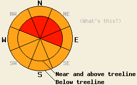
Near and above treeline, avalanche danger is HIGH on NW-N-NE-E aspects on slopes 35 degrees and steeper. Below treeline, avalanche danger is CONSIDERABLE in open areas on all aspects on slopes 35 degrees and steeper. Large destructive avalanches are possible today. |
|
|
|
A high intensity storm system is moving through the region this morning. Since the start of snowfall yesterday afternoon, an additional 11 to 17 inches of new snow has fallen across the forecast area with more on the way. Snowfall rates are at 1 to 2 inches per hour in most locations this morning with continued high intensity snowfall expected until around noon. Air temperatures have been steadily warming over the past 24 hours with the maximum air temperatures for the period occurring around 5am this morning. Snow level is forecast at around 5,000' for the remainder of today's snowfall. Ridgetop winds remain out of the southwest this morning and are moderate to strong in speed. Moderate to strong southwest to west winds are expected to continue through today. As snowfall tapers to showers by this evening, winds are forecast to shift to the north and east. Continued cloudy skies are expected overnight and for tomorrow.
Observations were made yesterday on Tamarack Peak (Mount Rose area), above Onion Creek (Donner Summit area), and on Poison Ridge (Bear Valley area). On Tamarack Peak evidence of three small skier or snowboarder triggered avalanches that most likely occurred on Saturday were noted. The avalanches occurred on the Proletariat face at 9,600' in E aspect near treeline terrain at convex points on the slope that ranged from 38 to 40 degrees in slope angle (photos, more info). A noticeable density inversion with higher density storm snow over lower density storm snow appeared to be the failure layer. The density inversion appeared to be less reactive yesterday than the day before. Continued wind transport of snow was observed above and below treeline in this area yesterday (pit profile, video, more info). Above Onion Creek, localized cracking and small skier triggered shooting cracks were observed to occur around 8,000' in wind affected areas, failing on a similar density inversion in the upper half of the storm snow. Rain on January 20-21 was noted to have percolated all the way to the ground in this area. No evidence of faceting near the newly formed and buried rain crust from that event was observed (more info). On Poison Ridge, right side up storm snow with no density inversion was observed in near treeline terrain on a N aspect at 8,400'. Snowpit tests indicated no failures within the storm snow at this location and that the lower snowpack remained supportable to the storm snow load above (pit profile, more info).
Data collected this morning by the Kirkwood Professional Ski Patrol at their snow study plot at 7,800' reveals ongoing instability within the storm snow. Snowpit tests show failure occurring on a layer of lower density storm snow that was deposited at the onset of snowfall yesterday afternoon. This snow was buried overnight under higher density snow associated with the slow and steady rise in air temperature observed across the forecast area.
Avalanche Concern #1 Wind slabs
Ongoing high intensity snowfall rates for much of this morning combined with wind transport will cause wind slabs to continue to build through most of today. Widespread areas of instability with natural avalanche activity is expected this morning in wind loaded areas near and above treeline on NW-N-NE-E aspects. Snowpack failure deep within the storm snow layers and large destructive avalanches are possible.
Avalanche Concern #2 Storm Slabs
In wind protected areas, high intensity snowfall rates through much of this morning will stress density inversions and any weak snow crystal types that exist within the storm snow. Unstable slabs 1 to 3 feet deep are expected in steep open areas below treeline. Snowpack failure is expected to remain within the recent storm snow and above the upper most rain crust that formed during this storm cycle in nearly all areas on January 20-21.
Near and above treeline, avalanche danger is HIGH on NW-N-NE-E aspects on slopes 35 degrees and steeper. Below treeline, avalanche danger is CONSIDERABLE in open areas on all aspects on slopes 35 degrees and steeper. Large destructive avalanches are possible today.
| 0600 temperature: | 24 to 29 deg. F. |
| Max. temperature in the last 24 hours: | 24 to 29 deg. F. |
| Average wind direction during the last 24 hours: | Southwest |
| Average wind speed during the last 24 hours: | 34 mph |
| Maximum wind gust in the last 24 hours: | 56 mph |
| New snowfall in the last 24 hours: | 11 to 17 inches |
| Total snow depth: | 22 to 65 inches |
For 7000-8000 ft: |
|||
| Monday: | Monday Night: | Tuesday: | |
| Weather: | Cloudy skies with periods of high intensity snowfall through noon. | Mostly cloudy skies with a slight chance of snow in the evening. | Cloudy skies. |
| Temperatures: | 24 to 31 deg. F. | 16 to 22 deg. F. | 26 to 33 deg. F. |
| Wind direction: | SW | NE | E shifting to NW in the afternoon. |
| Wind speed: | 35 to 40 mph with gusts to 60 mph, decreasing to 25 to 30 mph with gusts to 40 mph in the afternoon. | 10 to 15 mph with gusts to 25 mph after midnight. | 20 to 25 mph with gusts to 40 mph. |
| Expected snowfall: | 8 to 14 in. | 0 to trace in. | O in. |
For 8000-9000 ft: |
|||
| Monday: | Monday Night: | Tuesday: | |
| Weather: | Cloudy skies with periods of high intensity snowfall through noon. | Mostly cloudy skies with a slight chance of snow in the evening. | Cloudy skies. |
| Temperatures: | 22 to 29 deg. F. | 16 to 22 deg. F. | 24 to 31 deg. F. |
| Wind direction: | SW | N | N |
| Wind speed: | 40 to 50 mph with gusts to 75 mph. | 15 to 25 mph with gusts to 35 mph. | 30 to 40 mph with gusts to 60 mph. |
| Expected snowfall: | 10 to 16 in. | 0 to trace in. | O in. |


This website is owned and maintained by the non-profit arm of the Sierra Avalanche Center. Some of the content is updated by the USDA avalanche forecasters including the forecasts and some observational data. The USDA is not responsible for any advertising, fund-raising events/information, or sponsorship information, or other content not related to the forecasts and the data pertaining to the forecasts.

