In partnership with: 
|
January 30, 2012 at 8:00 am |
|
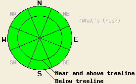
The avalanche danger remains LOW for all elevations and aspects. Continue to use normal caution traveling in the backcountry. |
|
|
|
The forecast calls for two weak systems to pass through the forecast area today and tomorrow. Each of these systems should bring some cloudiness and slightly cooler temperatures to the region; however, neither should produce any measurable precipitation. Each system should also bring a period of increased southwest winds. The first of these systems should move through this morning. The cloud cover and winds started increasing yesterday afternoon and should persist through this morning. Later today the winds should decrease as this system exits the region. Similar weather should prevail tomorrow as the second system impacts the area.
More settlement and consolidation continues to occur across the forecast area. The warm days and cold nights have allowed spring corn snow conditions to form on many slopes that face the southern half of the compass. Yesterday on Red Lake Peak, about two inches of soft corn snow existed on the SE-S-SW aspects above 8400 ft by 11:30 in the morning. Below this soft surface layer, a three to four inch thick frozen melt-freeze crust existed with strong well bonded snow underneath it. On the lower elevation southerly facing slopes below 8400 ft enough melting had occurred by noon for the snow to become wet, unsupportable, and "punchy" in some places. Some signs of small wet surface snow instabilities from previous days did remain in the form some pinwheels and roller balls (photo, more info). On the other aspects (E-NE-N-NW-W) a frozen crust existed on the snow surface at all elevations. In most areas this ice crust could support a skiers weight (photo). Below this crust hand pits also showed a mostly stable snowpack consisting of well bonded rounded snow grains.
Avalanche Concerns:
Avalanche activity should remain unlikely again today. Even though the snow surface likely refroze in most places last night, warmer overnight temperatures and some cloud cover should prevented a strong refreeze similar to the ones that have occurred the last few days. This being said several days of melt-freeze cycles, low sun angles, slightly cooler daytime highs, and more cloud cover should all work together to prevent significant warming and melting from occurring today. Sun exposed SE-S-SW slopes may soften and melt enough for some small wet snow instabilities to form; however, these should remain more limited and smaller than the activity that has occurred on previous days. A small snow slide pushing a person into or a person sliding down an icy slope into high consequence terrain where cliffs, rocks, trees and other terrain traps could harm that person remains the biggest hazard.
The avalanche danger remains LOW for all elevations and aspects. Continue to use normal caution traveling in the backcountry.
| 0600 temperature: | 29-33 deg. F. |
| Max. temperature in the last 24 hours: | 40-46 deg. F. |
| Average wind direction during the last 24 hours: | Southwest |
| Average wind speed during the last 24 hours: | Along the Sierra Crest: 20 mph | In the Mt Rose area: 30 mph |
| Maximum wind gust in the last 24 hours: | Along the Sierra Crest: 36 mph | In the Mt Rose area: 58 mph |
| New snowfall in the last 24 hours: | O inches |
| Total snow depth: | 19-37 inches |
For 7000-8000 ft: |
|||
| Monday: | Monday Night: | Tuesday: | |
| Weather: | Cloudy in the morning becoming partly cloudy in the afternoon | Mostly cloudy | Partly cloudy |
| Temperatures: | 36-42 deg. F. | 19-29 deg. F. | 34-38 deg. F. |
| Wind direction: | Southwest shifting to the west in the afternoon | Southwest | Southwest |
| Wind speed: | 20-25 mph with gusts to 35 mph decreasing to 10-15 mph in the afternoon | Light winds increasing to 15-20 mph with gusts to 30 mph after midnight | 15-20 mph with gusts to 30 mph |
| Expected snowfall: | O in. | O in. | O in. |
For 8000-9000 ft: |
|||
| Monday: | Monday Night: | Tuesday: | |
| Weather: | Cloudy in the morning becoming partly cloudy in the afternoon | Mostly cloudy | Partly cloudy |
| Temperatures: | 29-35 deg. F. | 19-27 deg. F. | 30-35 deg. F. |
| Wind direction: | Southwest shifting to the west in the afternoon | Southwest | Southwest shifting to the west in the afternoon |
| Wind speed: | 35-40 mph with gusts to 55 mph decreasing to 20-25 mph with gusts to 35 mph in the afternoon | 15-20 mph increasing to 30-35 mph with gusts to 50 mph after midnight | 30-35 mph with gusts to 50 mph decreasing to 20-25 mph with gusts to 40 mph in the afternoon |
| Expected snowfall: | O in. | O in. | O in. |


This website is owned and maintained by the non-profit arm of the Sierra Avalanche Center. Some of the content is updated by the USDA avalanche forecasters including the forecasts and some observational data. The USDA is not responsible for any advertising, fund-raising events/information, or sponsorship information, or other content not related to the forecasts and the data pertaining to the forecasts.

