In partnership with: 
|
February 7, 2012 at 7:56 am |
|
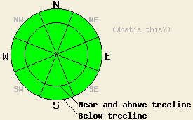
Avalanche danger remains LOW for all elevations and aspects. Use normal caution when traveling in the backcountry. |
|
|
|
Snow showers started earlier this morning as a disorganized low pressure system begins to impact the area. These show showers should become more widespread this afternoon before tapering off tonight as the system exits the region. This system should push through the area relatively quickly and should only produce one to two inches of new snow in the mountains today. It will bring colder air with it which will keep daytime highs in the low to mid 30's today and tomorrow. The winds should also increase today and this evening due to this low pressure. As the system exits the region tomorrow the winds should shift back to the north and east, and a high pressure ridge should start rebuilding over the forecast area.
Yesterday observations on S-SE-E-NE-N aspects on Andesite Ridge showed a wide range of snow surface conditions with a mostly stable snowpack below the surface layers. On the northerly aspects a mix of breakable crusts, wind scoured crusts, and patches of shallow, soft recent snow existed (photo). Just below the surface on the N-NE aspects, a layer of weak sugary snow (facets) has formed similar to those seen elsewhere in the forecast area. The same faceting process that formed this layer also continues to break down the surface rain crust. Firm, mostly frozen melt-freeze conditions reside on the S-SE aspects. Observations showed signs that only the top half to one inch of snow softened on these aspects yesterday above 7200 ft (photo). On the east aspects, a less thick but completely frozen melt-freeze layer existed on top of well consolidated snow below.
Today's Avalanche Concerns:
Today's one to two inches of new snow should not add enough weight to the snowpack to break the weak layer of near surface facets that has formed below the rain crust on the northerly aspects. The new snow combined with south winds may create a few small, shallow, and isolated wind slabs on the NW-N-NE aspects near and above treeline today. Minor cracking could occur on these slabs; however, they should not grow large enough to pose a major threat to backcountry travelers unless more snow falls than forecasted. Even though avalanche activity will remain unlikely today, icy slopes with a dusting of new snow, exposed rocks and trees, cliffs, and other terrain traps could still magnify the consequences of even the smallest snow slides or falls. Continue to use caution when traveling in the backcountry.
Avalanche danger remains LOW for all elevations and aspects. Use normal caution when traveling in the backcountry.
| 0600 temperature: | 25-28 deg. F. |
| Max. temperature in the last 24 hours: | 41-46 deg. F. |
| Average wind direction during the last 24 hours: | Variable mostly between east and southwest |
| Average wind speed during the last 24 hours: | 5-15 mph |
| Maximum wind gust in the last 24 hours: | 36 mph |
| New snowfall in the last 24 hours: | 0-1 inches |
| Total snow depth: | 20-36 inches |
For 7000-8000 ft: |
|||
| Tuesday: | Tuesday Night: | Wednesday: | |
| Weather: | Scattered snow showers in the morning. Snow showers becoming more widespread in the afternoon. | Cloudy with scattered snow showers in the evening. Snow showers should become isolated and taper off after midnight. | Partly cloudy |
| Temperatures: | 30-35 deg. F. | 23-28 deg. F. | 32-39 deg. F. |
| Wind direction: | South | South | Northeast |
| Wind speed: | 15-20 mph with gusts to 30 mph | 10-15 mph decreasing after midnight | 10-15 mph in the afternoon |
| Expected snowfall: | 1-2 in. | trace to 0 in. | O in. |
For 8000-9000 ft: |
|||
| Tuesday: | Tuesday Night: | Wednesday: | |
| Weather: | Scattered snow showers in the morning. Snow showers becoming more widespread in the afternoon. | Cloudy with scattered snow showers in the evening. Snow showers should become isolated and taper off after midnight. | Partly cloudy |
| Temperatures: | 27-32 deg. F. | 21-26 deg. F. | 30-36 deg. F. |
| Wind direction: | South | South | Northeast |
| Wind speed: | 30-35 mph with gusts to 50 mph decreasing to 20-25 mph with gusts to 35 mph in the afternoon | 10-15 mph with gusts to 30 mph becoming light after midnight | 10-15 mph with gusts to 25 mph in the afternoon |
| Expected snowfall: | 1-2 in. | trace to 0 in. | O in. |


This website is owned and maintained by the non-profit arm of the Sierra Avalanche Center. Some of the content is updated by the USDA avalanche forecasters including the forecasts and some observational data. The USDA is not responsible for any advertising, fund-raising events/information, or sponsorship information, or other content not related to the forecasts and the data pertaining to the forecasts.

