In partnership with: 
|
February 13, 2012 at 8:00 am |
|
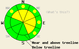
MODERATE avalanche danger exists near and above treeline on the NW-N-NE-E-SE aspects on slopes steeper than 35 degrees. Pockets of MODERATE danger exist on the NW-N-NE-E-SE aspects on slopes steeper than 35 degrees below treeline. MODERATE danger means that human-triggered avalanches are possible today. |
|
|
|
The southwest winds and cloud cover began increasing yesterday as the current storm approached the area. By midnight snow had begun to fall in the mountains. Since then four to seven inches of new snow has accumulated. The snow and southwest winds should continue today with the forecast calling for another two to six inches of accumulation by the end of the day. The cold air associated with this system should keep temperatures in the low 20's today. As the storm moves away from the region tonight, snow showers should taper off and the winds should shift to the north and northeast. A small high pressure building over the forecast area tomorrow could allow some clearing and a decrease in wind speeds. Daytime highs should also climb a few degrees higher tomorrow.
Observers and remote senors both have indicated that the new snow consists of low density, light, cold snow. The Kirkwood Ski Patrol reported evidence of a weak layer near the base of the new snow in their snow study plots this morning. Observations from across the forecast area prior to this storm have shown a mix of weak snow (facets) and crusts near the surface on the NW-N-NE aspects. Data collected on Becker Peak yesterday showed similar conditions (snowpit). In this area as in other locations, the process that created the weak facets has also weakened the surface crusts to the point that they have become very thin and very brittle. Tests performed on the near surface weak layers and the crusts have show that they break easily. On the SE-S-SW aspects well consolidated melt-freeze snow exists in most areas. Yesterday on Becker Peak, one to two inches of soft wet snow did form on these sun-exposed southerly aspects. The E aspects have a mix of conditions with some of the more shaded easterly slopes looking more like the northerly aspects and the sunnier ones looking more like the southerly aspects. On all aspects recent snowpits including the one from Becker yesterday have shown strong snow exists below the near surface weak layers.
Today's Avalanche Concerns: Storm Slabs and Wind Slabs
By the end of the day the current storm could leave a foot of total accumulation on top of the snowpack. This new snow combined with southwest winds strong enough to transport snow will form new slabs on top of the existing snowpack today. As snow and wind continue today, these slabs will continue to grow and become more widespread. At the base of the new slabs, a possible weak layer does exist on the northerly aspects in the form of the near surface facets mentioned above. Adding a person's weight to this combination of a new slab on top of an old weak layer could break the bonds holding the slab in place and cause an avalanche. The largest and most fragile slabs will exist on the most heavily wind loaded N-NE-E aspects near and above treeline. Some fragile wind slabs could also form on the cross loaded NW and SE facing gullies today. Human-triggerable soft slabs could also exist on open NW-N-NE-E-SE aspects below treeline today.
MODERATE avalanche danger exists near and above treeline on the NW-N-NE-E-SE aspects on slopes steeper than 35 degrees. Pockets of MODERATE danger exist on the NW-N-NE-E-SE aspects on slopes steeper than 35 degrees below treeline. MODERATE danger means that human-triggered avalanches are possible today.
| 0600 temperature: | 17-22 deg. F. |
| Max. temperature in the last 24 hours: | 31-38 deg. F. |
| Average wind direction during the last 24 hours: | Southwest |
| Average wind speed during the last 24 hours: | 10 mph yesterday. Then increasing overnight to 25-30 mph |
| Maximum wind gust in the last 24 hours: | 49 mph |
| New snowfall in the last 24 hours: | 4-7 inches |
| Total snow depth: | 22-36 inches |
For 7000-8000 ft: |
|||
| Monday: | Monday Night: | Tuesday: | |
| Weather: | Cloudy with snow in the morning. Snow showers and clouds decreasing during the day. | Cloudy with show showers likely in the evening. Snow showers tapering off overnight. | Mostly cloudy in the morning then becoming partly cloudy in the afternoon. Slight chance of snow showers through the day. |
| Temperatures: | 22-28 deg. F. | 17-22 deg. F. | 24-31 deg. F. |
| Wind direction: | Southwest shifting to the west in the afternoon | Northwest | Variable |
| Wind speed: | 10-20 mph with gusts to 35 mph decreasing to 10-15 mph with gusts to 25 mph in the afternoon | 10-15 mph with gusts to 25 mph | 10 mph |
| Expected snowfall: | 2-6 in. | up to 2 in. | O in. |
For 8000-9000 ft: |
|||
| Monday: | Monday Night: | Tuesday: | |
| Weather: | Cloudy with snow in the morning. Snow showers and clouds decreasing during the day. | Cloudy with show showers likely in the evening. Snow showers tapering off overnight. | Mostly cloudy in the morning then becoming partly cloudy in the afternoon. Slight chance of snow showers through the day. |
| Temperatures: | 17-23 deg. F. | 14-20 deg. F. | 19-26 deg. F. |
| Wind direction: | Southwest shifting to the west in the afternoon | North | North shifting to the northeast in the afternoon |
| Wind speed: | 20-30 mph with gusts to 50 mph decreasing to 15-20 mph with gusts to 35 mph in the afternoon | 20-25 mph with gusts to 40 mph | 20-30 mph with gusts to 40 mph decreasing to 15-20 mph with gusts to 30 mph in the afternoon |
| Expected snowfall: | 2-6 in. | up to 2 in. | O in. |


This website is owned and maintained by the non-profit arm of the Sierra Avalanche Center. Some of the content is updated by the USDA avalanche forecasters including the forecasts and some observational data. The USDA is not responsible for any advertising, fund-raising events/information, or sponsorship information, or other content not related to the forecasts and the data pertaining to the forecasts.

