In partnership with: 
|
February 18, 2012 at 8:00 am |
|
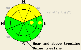
On slopes steeper than 34 degrees, MODERATE avalanche danger will persist on NW-N-NE aspects in both above and below treeline terrain due to a persistent weak layer near the base of the recent snow. Some isolated pockets of MODERATE danger may also exist on the shaded and sheltered E aspects. Human-triggered avalanches remain possible in these areas. |
|
|
|
Cloud cover started increasing late yesterday afternoon and became widespread during the night due to a cold front approaching from the north. This front should keep temperatures much cooler over the forecast area through tomorrow. The winds shifted back to the southwest ahead of this system and should increase some today. This system does have some moisture associated with it and could produce some snow showers over the forecast area. The best chances for more widespread and consistent snowfall will occur later in the day and into this evening. Currently, the forecast calls for up to one inch of accumulation by this evening. After this front moves through the area, temperatures should remain cool as another high pressure ridge builds over the forecast area tomorrow bringing clearer skies, northerly winds, and dry conditions.
Yesterday observations from around the forecast area (Red Lake Peak, Stevens Peak, Waterhouse Peak - videos, photos, more info, Becker Peak, Mt. Tallac, Silver Peak, Deep Creek - videos, photos, more info, and Incline Lake Peak photos, pit profile, more info) all showed the Jan 26th rain crust with weak sugary faceted snow below it and recent snow above it. The new snow exhibited various amounts of slab formation depending on location. In the areas that it had coalesced into more of a slab signs of instability including whumphing, collapsing, and snowpit tests showing that fractures can both initiate and then propagate along the weak layer existed. These indicators of snowpack instability existed on northerly aspects in areas on Stevens Peak, on Mt. Tallac, in Deep Creek, on Silver Peak, and in the Mt. Rose backcountry. Observers on Red Lake Peak reported seeing one avalanche while looking back on a NE facing slope near Frog Lake across Carson Pass. This slide occurred yesterday morning. It likely failed on the the facets below the rain crust, and an intentional cornice dropped onto the slope likely provided the trigger. In the most sheltered and shaded areas like the lower elevations in Deep Creek, Incline Lake Peak, on Becker Peak, and on Waterhouse Peak observers reported less slab formation and few signs of instability. A mix of wet snow and breakable crusts existed on the sun-exposed southerly and easterly aspects by yesterday afternoon.These slopes should remain frozen today.
Today's Primary Avalanche Concern: Persistent Slabs
The persistent weak layer of facets underneath the Jan 26th rain crust remains widespread and continues to lose strength. Meanwhile the recent snow above the crust continues gain strength. As the new snow gains strength, it acts more and more like a slab layer. This combination of slab formation and a persistent weak layer will allow human triggered avalanches to remain possible today. NW-N-NE facing terrain where the strong east winds have not scoured much of the new snow away represent the most worrisome places for this kind of instability. Avalanches resulting from this type of instability would entrain all of the new snow and could easily bury a person. This kind of instability does not go away quickly and often grows more unstable days after the last storm as more of the recent snow consolidates. In areas where less consolidation has occurred in the new snow, less of a slab layer exists and the risk of avalanche activity remains less. Careful snowpack observation and evaluation including fracture propagation tests like the extended column test (here's a video explaining the test and how to perform it) can help determine where slabs may exist on top of the persistent weak layer. Combining this data with safe travel techniques and cautious terrain choices can help keep backcountry travel fun and safe.
On slopes steeper than 34 degrees, MODERATE avalanche danger will persist on NW-N-NE aspects in both above and below treeline terrain due to a persistent weak layer near the base of the recent snow. Some isolated pockets of MODERATE danger may also exist on the shaded and sheltered E aspects. Human-triggered avalanches remain possible in these areas.
| 0600 temperature: | 25-28 deg. F. |
| Max. temperature in the last 24 hours: | 35-44 deg. F. |
| Average wind direction during the last 24 hours: | Southwest |
| Average wind speed during the last 24 hours: | 10-15 mph |
| Maximum wind gust in the last 24 hours: | 36-46 mph |
| New snowfall in the last 24 hours: | O inches |
| Total snow depth: | 26-36 inches |
For 7000-8000 ft: |
|||
| Saturday: | Saturday Night: | Sunday: | |
| Weather: | Mostly cloudy with isolated snow showers in the morning. Snow showers becoming scattered in the afternoon. | Mostly cloudy with scattered snow showers | Mostly cloudy |
| Temperatures: | 24-31 deg. F. | 11-18 deg. F. | 22-29 deg. F. |
| Wind direction: | Southwest | West | Northwest |
| Wind speed: | 15-20 mph with gusts to 35 mph | 10-15 mph with gusts to 30 mph | 10-15 mph becoming light in the afternoon |
| Expected snowfall: | up to 1 in. | O in. | O in. |
For 8000-9000 ft: |
|||
| Saturday: | Saturday Night: | Sunday: | |
| Weather: | Mostly cloudy with isolated snow showers in the morning. Snow showers becoming scattered in the afternoon. | Mostly cloudy with scattered snow showers | Mostly cloudy |
| Temperatures: | 21-28 deg. F. | 9-16 deg. F. | 21-27 deg. F. |
| Wind direction: | Southwest | West | Northwest |
| Wind speed: | 25-35 mph with gusts to 55 mph | 20-30 mph with gusts to 45 mph | 10-15 mph with gusts to 25 mph |
| Expected snowfall: | up to 1 in. | O in. | O in. |


This website is owned and maintained by the non-profit arm of the Sierra Avalanche Center. Some of the content is updated by the USDA avalanche forecasters including the forecasts and some observational data. The USDA is not responsible for any advertising, fund-raising events/information, or sponsorship information, or other content not related to the forecasts and the data pertaining to the forecasts.

