In partnership with: 
|
February 19, 2012 at 8:01 am |
|
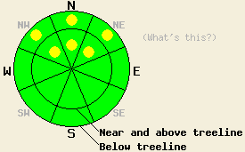
On slopes steeper than 35 degrees, pockets of MODERATE avalanche danger will persist on NW-N-NE aspects in both above and below treeline terrain due to a persistent weak layer near the base of the recent snow. Human-triggered avalanches remain possible in these areas today. |
|
|
|
Cold, mostly clear, and calmer weather should prevail over the forecast area today due to a high pressure ridge. Cold air that moved into the region behind yesterday's cold front should keep today's highs in the 20's. The southwest winds that decreased significantly overnight should remain light to moderate in speed today. Cloud cover should begin to rebuild over the forecast area as another low pressure system moves through the region tonight and tomorrow. This system could bring some additional snow showers to the area, but the forecast calls for little to no accumulation as a result of these showers. Areas north of Highway 50 will hold the best chances for snow showers tomorrow.
Observations continue to show a persistent weak layer at the base of the new snow. On Andesite Ridge yesterday (photos, more info), two skier triggered whumpfs occurred on sheltered NW and NE aspects near treeline. Nearby hand pits revealed that the whumpfing resulted due to a collapse of the weak layer of facets underneath the Jan 26th rain crust. Ski cuts on nearby test slopes where the recent snow had consolidated enough to form a soft slab did not produce failures or cracking. Extended column tests on similar slopes in the area also did not indicate that fractures could easily travel through the weak layer even though other tests showed that it does not take much force to initiate those fractures. This seemingly conflicting data shows how variable the snowpack can be even in a small area. Skiers on Echo Peak noted a some slab conditions on the upper elevation slopes which gave way to softer less consolidated snow below treeline on more sheltered northerly aspects. Surface conditions in both of these areas ranged from frozen sometimes breakable sometimes supportable crusts on the E-SE-S-SW-W aspects to scoured surfaces on the exposed N-NE aspects to areas of softer snow on the sheltered NW-N-NE aspects.
Today's Primary Avalanche Concern: Persistent Slabs
Even though observations have shown some indications that the persistent weak has started to adjust to its recent load, adding the weight of person to the snowpack in the right place could still cause a fracture in this layer. The recent snow above this persistent weak layer still represents a slab layer in many places. This combination of slab formation in the recent snow and a persistent weak layer will allow human triggered avalanches to remain possible today. Open NW-N-NE facing terrain that the strong east winds did not scour on Feb 15-16 represent the most worrisome places for this kind of instability. In more sheltered areas where less consolidation has occurred in the new snow, less of a slab layer exists and the risk of avalanche activity remains less. Avalanches resulting from this type of instability would entrain all of the new snow and could easily bury a person. This kind of instability can take a long time to completely heal. Careful snowpack observation and evaluation including fracture propagation tests like the extended column test (here's a video explaining the test and how to perform it), lots of hand pits, slope cuts on small test slopes, and a keen observant attitude can help determine where slabs may exist on top of the persistent weak layer. Combining this data with safe travel techniques and cautious terrain choices can help keep backcountry travel fun and safe.
On slopes steeper than 35 degrees, pockets of MODERATE avalanche danger will persist on NW-N-NE aspects in both above and below treeline terrain due to a persistent weak layer near the base of the recent snow. Human-triggered avalanches remain possible in these areas today.
| 0600 temperature: | 10-16 deg. F. |
| Max. temperature in the last 24 hours: | 26-32 deg. F. |
| Average wind direction during the last 24 hours: | Southwest yesterday becoming variable after midnight |
| Average wind speed during the last 24 hours: | 20-30 mph decreasing after midnight to 5-10 mph |
| Maximum wind gust in the last 24 hours: | 47-57 mph |
| New snowfall in the last 24 hours: | O inches |
| Total snow depth: | 26-36 inches |
For 7000-8000 ft: |
|||
| Sunday: | Sunday Night: | Monday: | |
| Weather: | Some lingering clouds this morning with skies becoming mostly sunny during the day | Partly cloudy becoming mostly cloudy overnight | Cloudy with a slight chance of snow in the morning. Chance of snow increasing in the afternoon. |
| Temperatures: | 23-30 deg. F. | 19-25 deg. F. | 27-34 deg. F. |
| Wind direction: | West | South | Southwest |
| Wind speed: | 10-15 mph in the morning decreasing in the afternoon | 10-15 mph with gusts to 25 mph after midnight | 10-15 mph in the afternoon |
| Expected snowfall: | O in. | O in. | Trace to 0 in. |
For 8000-9000 ft: |
|||
| Sunday: | Sunday Night: | Monday: | |
| Weather: | Some lingering clouds this morning with skies becoming mostly sunny during the day | Partly cloudy becoming mostly cloudy overnight | Cloudy with a slight chance of snow in the morning. Chance of snow increasing in the afternoon. |
| Temperatures: | 22-28 deg. F. | 15-22 deg. F. | 23-30 deg. F. |
| Wind direction: | West | West shifting to the south after midnight | West |
| Wind speed: | 15-25 mph with gusts to 40 mph decreasing to gusts to 30 mph in the afternoon | 20-25 mph with gusts to 35 mph | 15-20 mph with gusts to 30 mph |
| Expected snowfall: | O in. | O in. | Trace to 0 in. |


This website is owned and maintained by the non-profit arm of the Sierra Avalanche Center. Some of the content is updated by the USDA avalanche forecasters including the forecasts and some observational data. The USDA is not responsible for any advertising, fund-raising events/information, or sponsorship information, or other content not related to the forecasts and the data pertaining to the forecasts.

