In partnership with: 
|
February 21, 2012 at 7:49 am |
|
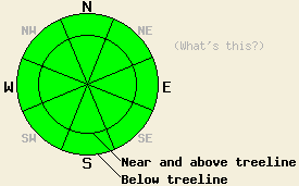
Avalanche danger is LOW for all elevations and aspects. Human triggered avalanches are unlikely but not impossible due to a persistent weak layer near treeline and below treeline on NW-N-NE aspects. |
|
|
|
Snow showers associated with the weather disturbance yesterday morning brought a trace of new snow to some parts of the forecast area over the past 24 hours. A second weather disturbance that brought some clouds to parts of the forecast area last night is moving out of the region this morning. High pressure will build over the area today. Decreasing cloud cover leading to plenty of sunshine by the afternoon is expected. Remote sensors are reporting air temperatures in the mid to upper 20s this morning for nearly all elevations. Maximum daytime air temperatures are forecast to reach into the 40s today for areas above 7,000'. Ridgetop winds shifted to the northeast yesterday evening and are moderate in speed this morning. Moderate speed northeast winds are forecast to continue through tomorrow. An additional 5 degrees of daytime warming is expected for tomorrow with high temperatures above 7,000' pushing 50 degrees.
Recent observations from around the forecast area continue to show the presence of a persistent weak layer of faceted snow and crust at the base of the recent new snow. This combination of weak layer and overlying slab exists in near treeline and below treeline areas on NW-N-NE aspects that were protected from scouring by strong NE winds on Feb 15. Most above treeline areas were heavily wind scoured during this event, removing the surface slab and exposing the crust at the snow surface. Observations made yesterday on Tamarack Peak (Mount Rose area), Mt. Tallac (Desolation Wilderness area), and on Mt. Judah (Donner Summit area) all showed the presence of this snowpack structure, but with a decrease in evidence of instability. Yesterday was the first day in the last 6 days where no whumphing was reported and all snowpit tests indicated that propagation of initiated fractures was unlikely.
Today's Primary Avalanche Concern: Persistent Slabs
It appears that the persistent weak layer of faceted snow and crust at the base of the recent new snow is taking a break for a while and going to sleep. That said, it is not impossible that one could find the right isolated pocket of lingering instability and trigger a slab avalanche today near or below treeline on a NW-N-NE aspect. It has just become unlikely at this time. Continue to use caution and exercise good travel habits in order to minimize risk. For the most part, this weak layer will now warrant close monitoring leading up to the next snowpack loading event when it may once again reactivate and become unstable with the possibility of contributing to deep slab avalanches.
Today's Secondary Avalanche Concern: Wet snow
With air temperatures climbing well above freezing and solar radiation getting closer to spring strength each day, areas of wet snow will form on E-SE-S-SW-W aspects today. High density wind affected snow surfaces on these aspects are expected to remain supportable. Areas of very shallow snowpack with exposed rocks and bushes may become unsupportable by afternoon. Wet snow instability is expected to remain fairly limited and not present a significant threat to backcountry travelers. In areas where wet snow becomes boot top deep, avoiding slopes above terrain traps such as cliffs and creek beds is a good idea as these terrain features greatly magnify the consequences of an otherwise small and inconsequential wet loose snow avalanche.
Avalanche danger is LOW for all elevations and aspects. Human triggered avalanches are unlikely but not impossible due to a persistent weak layer near treeline and below treeline on NW-N-NE aspects.
| 0600 temperature: | 25 to 27 deg. F. |
| Max. temperature in the last 24 hours: | 32 to 37 deg. F. |
| Average wind direction during the last 24 hours: | Southwest shifting to northeast |
| Average wind speed during the last 24 hours: | Sierra Crest 8 mph | Mount Rose 15 mph |
| Maximum wind gust in the last 24 hours: | Sierra Crest 29 mph | Mount Rose 41 mph |
| New snowfall in the last 24 hours: | 0 to trace inches |
| Total snow depth: | 26 to 36 inches |
For 7000-8000 ft: |
|||
| Tuesday: | Tuesday Night: | Wednesday: | |
| Weather: | Mostly cloudy skies in the morning, becoming partly cloudy. | Partly cloudy skies. | Sunny skies. |
| Temperatures: | 39 to 46 deg. F. | 28 to 34 deg. F. | 41 to 51 deg. F. |
| Wind direction: | NE | NE | NW |
| Wind speed: | 15 to 25 mph with gusts to 40 mph. | 15 to 20 mph with gusts to 30 mph. | 15 to 20 mph with gusts to 30 mph. |
| Expected snowfall: | O in. | O in. | O in. |
For 8000-9000 ft: |
|||
| Tuesday: | Tuesday Night: | Wednesday: | |
| Weather: | Mostly cloudy skies in the morning, becoming partly cloudy. | Partly cloudy skies. | Sunny skies. |
| Temperatures: | 39 to 45 deg. F. | 25 to 32 deg. F. | 44 to 50 deg. F. |
| Wind direction: | NE | NE | NW |
| Wind speed: | 30 to 40 mph with gusts to 60 mph. Gusts decreasing to 50 mph in the aftenoon. | 20 to 30 mph with gusts to 45 mph. | 20 to 30 mph with gusts to 45 mph. |
| Expected snowfall: | O in. | O in. | O in. |


This website is owned and maintained by the non-profit arm of the Sierra Avalanche Center. Some of the content is updated by the USDA avalanche forecasters including the forecasts and some observational data. The USDA is not responsible for any advertising, fund-raising events/information, or sponsorship information, or other content not related to the forecasts and the data pertaining to the forecasts.

