In partnership with: 
|
February 28, 2012 at 7:59 am |
|
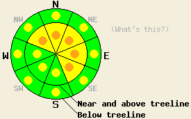
Near and above treeline avalanche danger is MODERATE with pockets of CONSIDERABLE danger forming by this afternoon in wind loaded areas on NW-N-NE-E-SE aspects, on slopes 35 degrees and steeper. On S-SW-W aspects, isolated areas of MODERATE danger will exist in cross loaded terrain. Below treeline, pockets of MODERATE danger are expected to form in open wind loaded areas on all aspects on slopes 35 degrees and steeper. A trend of increasing avalanche danger is expected to occur this afternoon through tomorrow. |
|
|
|
New snowfall amounts from the past 24 hours are running 6 to 12 inches along the Sierra Crest and 8 to 16 inches along the Carson Range. The greatest snowfall accumulations occurred north of Hwy 88. New snow density ranged from 3% to 4% water content. A break in the weather will occur this morning, before increasing cloud cover and increasing winds build over the forecast area ahead of an approaching storm system. Remote sensors are reporting air temperatures above 7,000' in the low to mid teens this morning. A significant spread in air temperatures between the middle and upper elevations is forecast for today with temperatures in the 7,000' to 8.000' range in the mid 20s to low 30s while air temperature above 8,000' are forecast in the mid teens to low 20s. Ridgetop winds have remained light for the past 24 hours. Increasing southwest winds becoming strong this afternoon are forecast to become gale force overnight with ridgetop guts over 100mph. The next round of snowfall will begin tonight with high intensity snowfall expected through mid day Wednesday.
Observations made yesterday in the Deep Creek drainage revealed very soft storm slabs with ongoing instability during the mid day and afternoon hours. A widespread natural avalanche cycle had occurred around 10 or 11am leaving behind 8 inch crowns on many NW-N-NE aspects both below treeline and near treeline on slopes steeper than 35 degrees. Lower angle slopes in the 30 to 35 degree range displayed widespread cracking but no avalanche activity. The storm slabs were noted to fail within the new snow on a layer of lightly rimed new snow crystals about 1.5 inches above the old/new snow interface. In the early afternoon hours, snowpit data and widespread skier triggered cracking indicated ongoing instability on this same layer (photos, pit profile, more info). As of yesterday afternoon, the new snow load was insufficient to reactivate the persistent weak layer of crusts and facets that exists in the top half to third of the old snow layers, mainly along the Sierra Crest. Observers in the Mount Rose area reported storm slab instability on N-NE aspects near and below treeline with small natural and skier triggered avalanches occurring within the top half of the storm snow creating 4 inch crowns.
Today's Primary Avalanche Concern: Wind Slabs
With very little wind over the past 24 hours, all of the accumulated storm snow sits on windward aspects and is available for wind transport today. Increasing southwest winds from light in speed this morning to strong this afternoon are expected to cause significant amounts of wind loading on NW-N-NE-E-SE aspects. This will place higher density wind slabs on top of lower density storm snow from yesterday, likely creating unstable conditions. Once the wind picks up today and these new wind slabs form, natural avalanche activity will become possible with human triggered avalanches likely.
Today's Secondary Avalanche Concern: Persistent Deep Slabs
As wind transported snow this afternoon and more new snow tonight accumulates and adds additional load to the snowpack, at some point the persistent weak layer of crusts and facets that exists within the upper half of snowpack is likely to reactivate and become unstable. Observations made around the forecast area over the past week have shown that this weak layer is most well developed on NW-N-NE aspects both near and below treeline along the Sierra Crest. Failure of the snowpack along this weak layer could allow for destructive slab avalanche activity involving slabs 2 to 4 feet thick that are composed of both new and old snow.
Near and above treeline avalanche danger is MODERATE with pockets of CONSIDERABLE danger forming by this afternoon in wind loaded areas on NW-N-NE-E-SE aspects, on slopes 35 degrees and steeper. On S-SW-W aspects, isolated areas of MODERATE danger will exist in cross loaded terrain. Below treeline, pockets of MODERATE danger are expected to form in open wind loaded areas on all aspects on slopes 35 degrees and steeper. A trend of increasing avalanche danger is expected to occur this afternoon through tomorrow.
| 0600 temperature: | 12 to 14 deg. F. |
| Max. temperature in the last 24 hours: | 19 to 25 deg. F. |
| Average wind direction during the last 24 hours: | Southwest |
| Average wind speed during the last 24 hours: | 5 mph |
| Maximum wind gust in the last 24 hours: | 30 mph |
| New snowfall in the last 24 hours: | 6 to 16 inches |
| Total snow depth: | 30 to 40 inches |
For 7000-8000 ft: |
|||
| Tuesday: | Tuesday Night: | Wednesday: | |
| Weather: | Partly cloudy skies, becoming mostly cloudy. | Cloudy skies with a chance of snow in the evening. Snow after midnight. | Cloudy skies with high intensity snowfall. |
| Temperatures: | 25 to 31 deg. F. | 12 to 19 deg. F. | 19 to 26 deg. F. |
| Wind direction: | W shifting to SW | SW | SW |
| Wind speed: | 10 to 15 mph with gusts to 25 mph, increasing to 25 to 35 mph with gusts to 45 mph in the afternoon. | 30 to 40 mph with gusts to 60 mph, increasing to 35 to 50 mph with gusts to 85 mph after midnight. | 45 to 55 mph with gusts to 90 mph. Gusts decreasing to 80 mph in the afternoon. |
| Expected snowfall: | O in. | 2 to 6 in. | 10 to 16 in. |
For 8000-9000 ft: |
|||
| Tuesday: | Tuesday Night: | Wednesday: | |
| Weather: | Partly cloudy skies, becoming mostly cloudy. | Cloudy skies with a chance of snow in the evening. Snow after midnight. | Cloudy skies with high intensity snowfall. |
| Temperatures: | 15 to 22 deg. F. | 8 to 15 deg. F. | 15 to 22 deg. F. |
| Wind direction: | W shifting to SW | SW | SW |
| Wind speed: | 10 to 20 mph with gusts to 30 mph, increasing to 30 to 40 mph with gusts to 60 mph. | 35 to 45 mph with gusts to 65 mph, increasing to 40 to 50 mph with gusts to 90 mph after midnight. | 60 to 70 mph with gusts 100 to 110 mph. |
| Expected snowfall: | O in. | 3 to 6 in. | 10 to 20 in. |


This website is owned and maintained by the non-profit arm of the Sierra Avalanche Center. Some of the content is updated by the USDA avalanche forecasters including the forecasts and some observational data. The USDA is not responsible for any advertising, fund-raising events/information, or sponsorship information, or other content not related to the forecasts and the data pertaining to the forecasts.

