In partnership with: 
|
March 12, 2012 at 7:00 am |
|
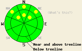
Pockets of MODERATE avalanche danger exist on NW-N-NE aspects on slopes 35 degrees and steeper in both above and below treeline terrain due to ongoing deep slab instability. The possibility of large destructive human triggered avalanches remains in these areas. For all other areas, avalanche danger is LOW. |
|
|
|
Yesterday's small storm left up to two inches of new snow on the mountains across the region. Precipitation ended yesterday as this system moved out of the area. Today should remain cool, windy, and dry before another stronger storm arrives over the region tonight. The winds should increase tonight and remain strong through tomorrow with average speeds of 70-100 mph along the ridge tops. This storm should also bring more snow to the mountains starting after midnight tonight and continuing into tomorrow. The forecast calls for 5-13 inches of new snow above 7000 ft by tomorrow afternoon. Moderate to heavy snowfall and strong winds should continue through Wednesday due to this system. Snow levels should rise above 7000 ft during this storm. Another colder stronger storm should arrive later this week bringing more wind and snow. Click here for a weather briefing from the Reno NWS.
Yesterday in the Mt Rose backcountry hard refrozen melt-freeze snow and frozen wind scoured surfaces existed on the southerly aspects. On the NW-N-NE-E aspects, a mix of small wind slabs, firm wind packed surfaces, breakable crusts, and some patches of softer snow existed. Observations on the Fireplug showed that prolonged melt-freeze conditions earlier this have produced a strong, stable, and sometimes shallow snowpack on the E-SE-S-SW aspects. On the NW-N-NE aspects in this area the persistent weak layer of crusts and weak sugary snow (facets) still exists a few feet down in the snowpack. As in other places around the forecast area, tests on this weak layer continue to indicate that once it breaks the resulting fracture can easily travel through this layer. On these aspects, the snow above this weak layer has consolidated into a strong slab layer.
Today's Avalanche Concern: Persistent Deep Slabs
As the slab above the persistent weak layer has become stronger, transmitting enough force through that slab to break that persistent weak layer has become more difficult. However, almost all of the recent observations indicate that if this layer breaks it would produce large deep slab avalanches. The right trigger applied to the slope in the right spot on the NW-N-NE aspects where this weak layer exists could cause this layer to fracture; thus human-triggered avalanches will remain possible on these aspects today in both above and below treeline terrain. Areas near exposed rock outcrops and cliffs, steep unsupported slopes, and slopes with trigger points represent locations where triggering a deep slab avalanche would be easier. Due to the way that these kind of layers behave, areas of stability and areas of instability could exist within a few feet of each other on the same slope. Several people could safely recreate on a slope before someone found the right trigger point and caused the slope to slide with everyone's tracks still on it. As more snow and wind add new slabs and weight to the snowpack tomorrow, avalanches resulting from the failure of this persistent weak layer should become more widespread and easier to trigger. Caution and conservative decision making remain prudent due to the variability of this layer and the consequences of its failure.
Pockets of MODERATE avalanche danger exist on NW-N-NE aspects on slopes 35 degrees and steeper in both above and below treeline terrain due to ongoing deep slab instability. The possibility of large destructive human triggered avalanches remains in these areas. For all other areas, avalanche danger is LOW.
| 0600 temperature: | 20-27 deg. F. |
| Max. temperature in the last 24 hours: | 25-33 deg. F. |
| Average wind direction during the last 24 hours: | Southwest |
| Average wind speed during the last 24 hours: | 50 mph |
| Maximum wind gust in the last 24 hours: | 91 mph |
| New snowfall in the last 24 hours: | 0-2 inches |
| Total snow depth: | 28-47 inches |
For 7000-8000 ft: |
|||
| Monday: | Monday Night: | Tuesday: | |
| Weather: | Mostly cloudy | Chance of snow in the evening. Snow becoming more widespread after midnight | Snow |
| Temperatures: | 30-38 deg. F. | 23-30 deg. F. | 35-41 deg. F. |
| Wind direction: | Southwest | Southwest | Southwest |
| Wind speed: | 25-40 mph with gusts to 60 mph | 25-40 mph with gusts to 60 mph | 40-60 mph with gusts to 80 mph |
| Expected snowfall: | O in. | up to 3 in. | 5-10 in. |
For 8000-9000 ft: |
|||
| Monday: | Monday Night: | Tuesday: | |
| Weather: | Mostly cloudy | Chance of snow in the evening. Snow becoming more widespread after midnight | Snow |
| Temperatures: | 23-30 deg. F. | 19-25 deg. F. | 28-35 deg. F. |
| Wind direction: | Southwest | Southwest | Southwest |
| Wind speed: | 45-60 mph with gusts to 90 mph | 70-90 mph with gusts to 110 mph increasing to 125 mph after midnight | 80-100 mph with gusts to 135 mph |
| Expected snowfall: | O in. | up to 3 in. | 5-10 in. |


This website is owned and maintained by the non-profit arm of the Sierra Avalanche Center. Some of the content is updated by the USDA avalanche forecasters including the forecasts and some observational data. The USDA is not responsible for any advertising, fund-raising events/information, or sponsorship information, or other content not related to the forecasts and the data pertaining to the forecasts.

