In partnership with: 
|
March 14, 2012 at 7:49 am |
|
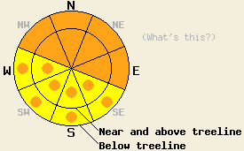
CONSIDERABLE avalanche danger exists at all elevations on NW-N-NE-E aspects on slopes 35 degrees and steeper due to ongoing deep slab instability, new snow, wind loading, and rain on snow. Large destructive human triggered avalanches are likely in these areas. Pockets of CONSIDERABLE danger may also form on all other aspects aspects below 8000 ft due to rain on snow. South of Hwy 50 and east of Lake Tahoe where less snow has fallen less avalanche danger exists. |
|
|
|
North of Echo Summit 10-15 inches of heavy wet snow has fallen since early Tuesday morning. Some sensors near Donner Summit have even reported up to 20 inches of new snow. Areas south of Echo Summit and east of Lake Tahoe have seen much less snow with accumulations in those areas between 2 and 7 inches. Currently snow levels remain around 6500 ft; however, the forecast calls for snow levels rising as high as 8000 ft today, tonight, and tomorrow. Above 8000 ft another 7-15 inches of snow could fall in the next 24 hours. Below 8000 ft this precipitation should arrive as a mix of rain and snow. As with the snow that fell last night, the north end of the forecast area along the Sierra Crest should see the most precipitation while areas east of the Lake and south of Echo Summit should see less. The southwest winds should decrease some today but still average between 50 and 70 mph with gusts to 90 mph along the ridge tops. Another colder stronger storm should arrive later this week bringing more wind and much more snow. Click here for a weather briefing from the Reno NWS.
Yesterday observations on Carson Pass (video, more info) and on Andesite Ridge (videos, more info) both showed the new heavy snow and old snow surface had not bonded well. On Andesite Ridge where significantly more snow fell, this interface failed during snowpit tests (video), and skiers could trigger shooting cracks resulting from the failure of this interface. In the Carson Pass area where much less new snow accumulated, snowpit tests (video) only showed failures at this interface on the most heavily wind loaded slopes. Ski cuts on steep test slopes in these areas only produced loose snow sluffs that entrained the new snow. Other recent observations around the forecast area have shown that a persistent weak layer of crusts and weak sugary snow (facets) still exists a few feet down in the snowpack. Tests on this layer still indicate that even though it may be difficult to start a fracture in these facets, once one starts it can travel along this weak layer.

Today's Primary Avalanche Concern: Persistent Deep Slabs
New wind slabs, new heavy wet snow, and rain on snow have and will continue to add weight to the snowpack. This added weight could re-awaken the deep persistent weak layer making large human-triggered deep slab avalanches likely in some areas on the NW-N-NE aspects today. Areas near exposed rock outcrops and cliffs, steep unsupported slopes, and slopes with trigger points represent locations where triggering a deep slab avalanche would be easiest. Areas north of Hwy 50 have more potential for these kinds of avalanches due to the fact that they have received significantly more snow. Even though the best window for natural avalanches likely occurred during the night some natural deep slab avalanche may remain possible today especially on slopes with larger new snow loads that receive rain today. Caution and conservative decision making remain prudent due to the variability of this layer and the consequences of its failure.

 Today's Secondary Avalanche Concerns: Wind Slabs and Storm Slabs
This storm has deposited new storm slabs and new wind slabs on top of the snowpack. In many areas these new slabs have not bonded very well to the old snow surfaces below them. Adding a person on top of these new slabs could break these bonds and cause avalanche activity. These avalanches could step down into the lower weak layers mentioned above resulting in deeper and more dangerous deep slab avalanches. Some natural avalanche activity involving these wind slabs as well as new storm slabs that form as more snowfall accumulates may remain possible today especially on slopes that receive rain. The largest and most fragile of these slabs will exist on wind loaded N-NE-E aspects and cross loaded NW and SE aspects north of Hwy 50 where more snow has fallen.
 Today's Third Avalanche Concern: Rain on Snow
With snow levels expected to rise as high as 8000 ft today, rain could affect many slopes that have a significant amount of new snow on them. Rain adds weight to the snowpack while at the same time weakening the snowpack by melting the bonds holding it together. Human triggered avalanches will become likely and natural avalanches will become possible on any slopes that receive rain today. The areas north of Hwy 50 where the most snow has fallen will hold the greatest potential for these kinds of avalanches. These avalanches could also trigger the persistent weak layer mentioned above resulting in deeper and more dangerous deep slab avalanches.
CONSIDERABLE avalanche danger exists at all elevations on NW-N-NE-E aspects on slopes 35 degrees and steeper due to ongoing deep slab instability, new snow, wind loading, and rain on snow. Large destructive human triggered avalanches are likely in these areas. Pockets of CONSIDERABLE danger may also form on all other aspects aspects below 8000 ft due to rain on snow. South of Hwy 50 and east of Lake Tahoe where less snow has fallen less avalanche danger exists.
| 0600 temperature: | deg. F. |
| Max. temperature in the last 24 hours: | deg. F. |
| Average wind direction during the last 24 hours: | |
| Average wind speed during the last 24 hours: | mph |
| Maximum wind gust in the last 24 hours: | mph |
| New snowfall in the last 24 hours: | O inches |
| Total snow depth: | inches |
For 7000-8000 ft: |
|||
| Wednesday: | Wednesday Night: | Thursday: | |
| Weather: | |||
| Temperatures: | deg. F. | deg. F. | deg. F. |
| Wind direction: | |||
| Wind speed: | |||
| Expected snowfall: | O in. | O in. | O in. |
For 8000-9000 ft: |
|||
| Wednesday: | Wednesday Night: | Thursday: | |
| Weather: | |||
| Temperatures: | deg. F. | deg. F. | deg. F. |
| Wind direction: | |||
| Wind speed: | |||
| Expected snowfall: | O in. | O in. | O in. |


This website is owned and maintained by the non-profit arm of the Sierra Avalanche Center. Some of the content is updated by the USDA avalanche forecasters including the forecasts and some observational data. The USDA is not responsible for any advertising, fund-raising events/information, or sponsorship information, or other content not related to the forecasts and the data pertaining to the forecasts.

